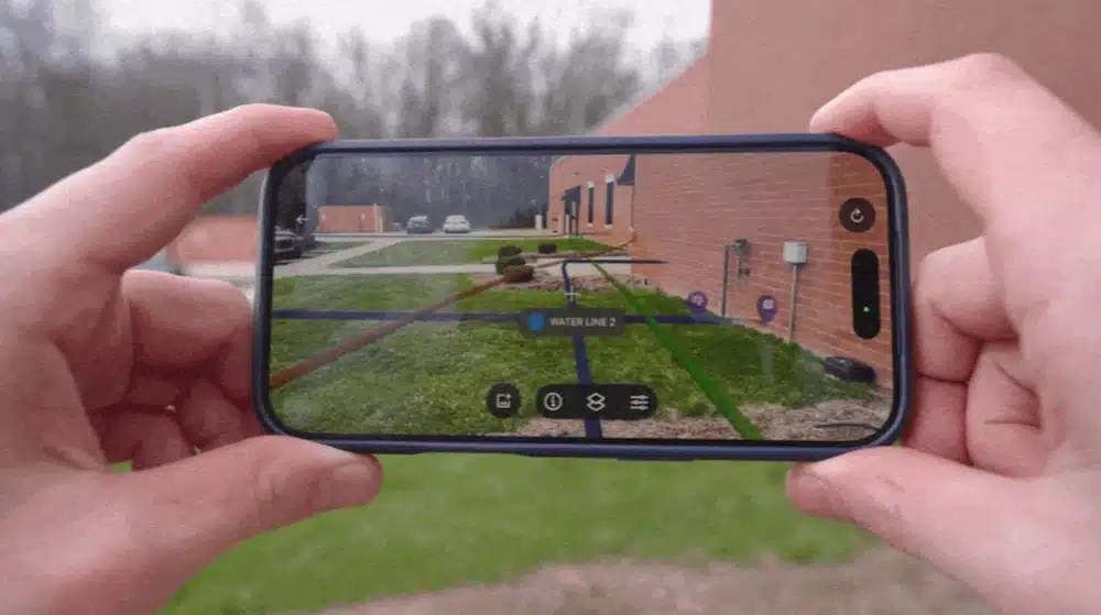
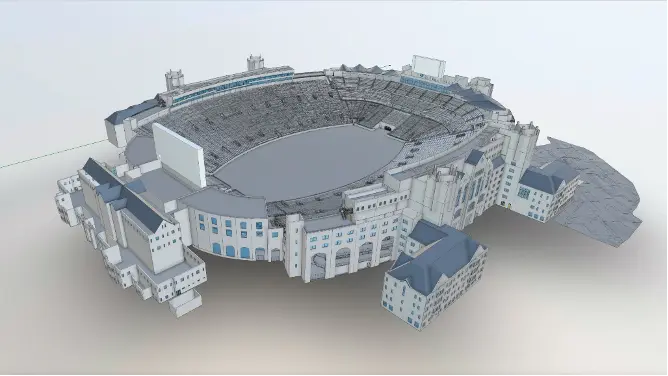
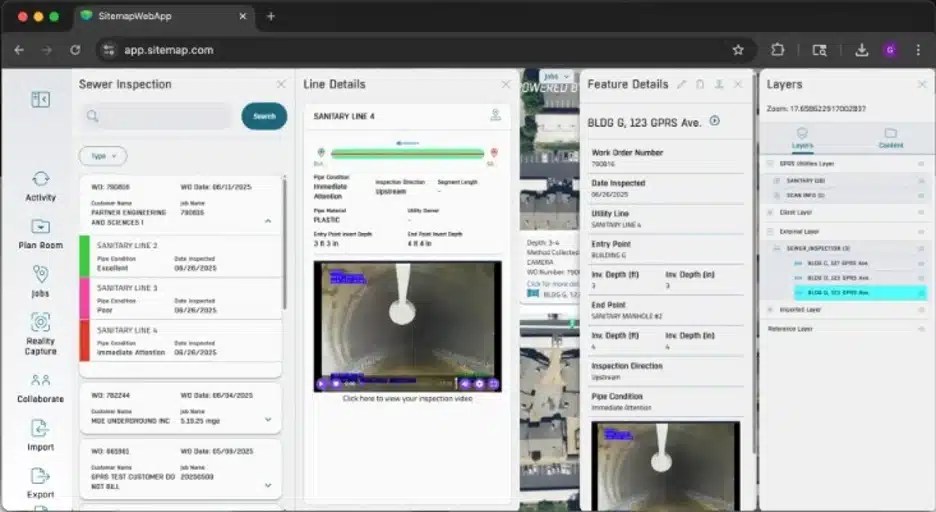
Articles

Environmental Services and Consultants: Safeguarding the Environment & Infrastructure

Environmental Services and Consultants: Safeguarding the Environment & Infrastructure

The role of environmental services and consultants in managing underground utilities when addressing environmental concerns at LUST sites (leaking underground storage tank sites) is of utmost importance. The world beneath our feet is vast and unforgiving, and the smallest error has the potential to endanger communities and the environment for decades. 

Environmental professionals employ advanced techniques and technologies to identify potential hazards, mitigate risk, and remediate contaminated areas. These processes are also crucial to achieving regulatory closure of LUST sites, which are a national concern that many states have begun to place more focus on.

read more
Unveiling the Power of Subsurface As-Builts: Enhancing Construction Efficiency with GPRS

Unveiling the Power of Subsurface As-Builts: Enhancing Construction Efficiency with GPRS

Traditionally, as-built drawings provided a visual representation of the final state of a project above the ground. With subsurface as-builts, construction professionals and even government agencies can gain access to a comprehensive and accurate picture of their infrastructure, both above and below ground. The creation of subsurface as builts requires more technology than your standard drawings. This technology includes things like ground penetrating radar, concrete scanning, 3D laser scanning, and more. All the technologies work together to create one clear, easy to understand image: the subsurface as built. The use of this technology is powering a revolution in construction and utility management, with the benefit of this method being in constant expansion. 

read more
Spotlight on National Safe Digging Month

Spotlight on National Safe Digging Month

One of GPRS’ favorite construction industry initiatives is National Safe Digging Month. Celebrated each April, NDSM boosts awareness and activities that promote safe digging practices. Recognized by the United States Congress and most state governors, this month of...

read more
Why Simplify Your Underground Utility Mapping?

Why Simplify Your Underground Utility Mapping?

Subsurface utilities demand respect during digging and construction. Incomplete utility mapping often fails to represent the multidimensional nature of utility infrastructure, which can cause problems down the line. This information may also exist in physical form...

read more
Keeping Municipal Workers Safe with SiteMap®

Keeping Municipal Workers Safe with SiteMap®

Municipal workers are the backbone of a community. The duties of municipal workers vary greatly, from accounting and permit processing, to law enforcement and emergency response. Municipal workers visit all corners of their communities to service residents and...

read more
How To Get A Free Personal SiteMap® Subscription

How To Get A Free Personal SiteMap® Subscription

As a facility manager, engineer, or project manager, making crucial decisions is a daily task. It is important to have accurate information so you can make the best of each project. As a new or existing GPRS customer, you can have access to a complimentary SiteMap®...

read more
How Facility Managers Centralized Their Data Using SiteMap®

How Facility Managers Centralized Their Data Using SiteMap®

Here at SiteMap®, powered by GPRS, we are more than just a standard facility management software; we are Collaboration Redefined™. Our innovative GIS software platform offers customizable data storage, mapping, and modeling solutions that go above and beyond the usual...

read more
Maximizing Construction Project Safety With SiteMap®

Maximizing Construction Project Safety With SiteMap®

GPRS, SiteMap’s founding company, is committed to the safety of every kind of construction project and the dedicated teams working on them. Our entire team prioritizes the safety of you, your team, and you job site so that you can go home at the end of the day, proud...

read more
Three Unique Industries SiteMap® Can Serve

Three Unique Industries SiteMap® Can Serve

The field of GIS technology and cloud-based infrastructure management solutions has been continuously growing to meet the unique needs of facility managers and their construction teams. A stand-out leader among the available solutions is SiteMap®, powered by GPRS....

read more
Addressing Our Customers Top 3 FAQ’s About SiteMap

Addressing Our Customers Top 3 FAQ’s About SiteMap

FINCH Brands, a premier consumer insights firm, recently performed a large-scale survey of qualified facility management respondents within the construction industry. These 110 respondents, who were vetted for their level of experience and management responsibilities,...

read more
Underground Mapping Solutions for Municipalities

Underground Mapping Solutions for Municipalities

Underground Mapping Solutions for Municipalities Whether you are managing a commercial, residential, or industrial construction project, it is crucial to properly maintain all your facility’s required permits, job site evaluation data, and most recent maps and models....

read more
Leak Detection Services, Mapping, and Modeling

Leak Detection Services, Mapping, and Modeling

Leaks and water main breaks can cause major damage by eroding soil and therefore creating underground voids. These voids can then severely compromise the integrity of buildings long before any water can even be seen at the surface. This issue is far more common than...

read more
Artificial Intelligence (AI) in Construction

Artificial Intelligence (AI) in Construction

Artificial Intelligence (AI) in Construction Artificial Intelligence (AI) is proving applicable across a variety of industries and construction is no exception. In fact, Artificial Intelligence use within the Construction market was recently valued at 519.63 million...

read more
The Top Three Utility Locating Errors and How to Avoid Them

The Top Three Utility Locating Errors and How to Avoid Them

The Top Three Utility Locating Errors and How to Avoid Them‍ The Common Ground Alliance (CGA) and their Data Reporting & Evaluation Committee have  issued their latest comprehensive account and analysis “of damages to buried infrastructure in the U.S. and Canada”...

read more
What is Infrastructure Asset Management Software?

What is Infrastructure Asset Management Software?

In Eric Too (of the Queensland University of Technology) and Linday Tay’s (of Bond University) paper, “Infrastructure Asset Management (IAM): Evolution and Evaluation,” infrastructure asset management (IAM) is defined as an emerging discipline which aims “to provide a...

read more
Streamlining Communication with SiteMap®

Streamlining Communication with SiteMap®

Recently FINCH Brands, a premier consumer insights firm, performed a large-scale survey of qualified respondents within the construction industry. All 110 respondents were responsible for making capital expenditure decisions for their facilities and managed one or...

read more
New Trends in Remodeling & Renovation

New Trends in Remodeling & Renovation

In a recent article, Bloomberg, reported that, “for the first time in 20 years, renovations have overtaken new construction in architectural billings in the US.” These new fiscal trends within renovations and remodeling pose new and exciting opportunities within the...

read more
10 Modern Tools for Utility Locating and Their Benefits

10 Modern Tools for Utility Locating and Their Benefits

Here at SiteMap®, powered by GPRS, we can deploy state-of-the-art Utility Locating Services leveraging the most advanced, industry-leading equipment to perform detailed inspections for our customers. Be it for a public or private property project, our unmatched...

read more
Lean Construction Principles & SiteMap

Lean Construction Principles & SiteMap

As defined by the Lean Construction Institute, Lean Construction is a process of project delivery and execution which relies on “methods of maximizing stakeholder value while reducing waste by emphasizing collaboration between teams on a project.” The key goal of this...

read more
Concrete Scanning in SiteMap’s Geographic Mapping Software

Concrete Scanning in SiteMap’s Geographic Mapping Software

As defined by Perry Testing Ltd, concrete scanning is “the process of scanning concrete using one or more forms of non-destructive technology.” This kind of site evaluation can utilize a number of tools such as cover meters, a ferroscan instrument, ultrasonic scanning...

read more
Managing Your Project with Connected Construction

Managing Your Project with Connected Construction

Considering any construction or mapping project through a technical lens can provide numerous benefits, streamlining processes being chief among them. However, in today’s construction industry, there is a typical documented disconnect among the parties involved, and a...

read more
How Much is GIS Software? Comparing Costs and Features

How Much is GIS Software? Comparing Costs and Features

Geographic Information Systems (GIS) are reinventing the way industrial designers are Visualizing the Built World™ by combining data, technology, software, and GPS to model and analyze spatially referenced data. These digital systems of viewing maps provide a more...

read more
Cloud-Native Geospatial: A New Way of Working

Cloud-Native Geospatial: A New Way of Working

Cloud-native geospatial mapping is the modern standard for data storage, offering a way for facilities, construction, and engineering teams to access data at any time, from anywhere. When your maps, permits, and site data are scattered, compiling them into one...

read more
What is Location Intelligence?

What is Location Intelligence?

Five Things You Need to Know About Location Intelligence Location intelligence is achieved via visualization and analysis of geospatial data. It is powered by geographical information systems (GIS) that allow users to store their geospatial data in real time to gain...

read more
3 Ways Digital Construction Tools Support LEAN Construction Projects

Visualize Your Data with Geographic Mapping Software

Modern Geographic Mapping Software is revolutionizing the data visualization capabilities available today. Through the combination of innovative data capturing methodologies and geographic information systems (GIS) technology, geographic sites can be fully scanned...

read more
Infrastructure Mapping Best Practices

Infrastructure Mapping Best Practices

What is infrastructure mapping? Infrastructure mapping can be described as the study of physical connectivity on different networks. It is a process of detailed maps that help to visualize your network and is essential for prevention of damage to facilities. These...

read more
Geospatial Mapping Data Storage and the Cloud

Geospatial Mapping Data Storage and the Cloud

Cloud-based GIS (Geographic Information System) data storage infrastructure comes with numerous benefits over traditional storage on local drives. An understanding of GIS will clarify why cloud data storage is the optimal choice. Geospatial technology “is a term used...

read more
What is Infrastructure Asset Management?

What is Infrastructure Asset Management?

Infrastructure asset management is the process of managing physical assets such as buildings, roads, and bridges. It includes activities such as planning, design, construction, operation, and maintenance. Infrastructure asset management is a critical part of overall...

read more
Three Ways Interactive Maps Benefit Your Facilities

Three Ways Interactive Maps Benefit Your Facilities

Managing the integrity of all aspects of your facilities, both above and below ground, can be an impossible task if your data is decentralized and outdated. Interactive maps bring order to chaos, expertly combining the layers of your geospatial data. In turn, this...

read more
Three Ways to Optimize Your Campus Utility Management

Three Ways to Optimize Your Campus Utility Management

Your campus—whether comprised of offices, university halls, or factory buildings—can sharpen its utility management strategy through the use of 3D utility mapping technology. There are efficiencies to be gained by electronically connecting the utility data across your...

read more
How Geospatial Infrastructure Mapping Companies Use Drones

How Geospatial Infrastructure Mapping Companies Use Drones

How Geospatial Infrastructure Mapping Companies Use Drones The use of drones, or unmanned aerial vehicles (UAVs), is reshaping the way that geospatial infrastructure mapping collects site data. Not only can this technology be used on construction sites, it is easily...

read more
$56,000 & 12 Weeks Of Downtime: How Is That “Easy?”

$56,000 & 12 Weeks Of Downtime: How Is That “Easy?”

Every time someone can’t find an up-to-date plan or communicates existing facility information incorrectly, it could cost you $56,000. Because $56,000 is the average cost to repair the damage caused by a utility strike. In a recent study of facility managers...

read more
Case Study: Culver Academies

Case Study: Culver Academies

Culver Academies aim is to serve their students steadfast and boldly. Their purpose is to provide students with the best whole person education in the country. To fulfill this purpose, Culver must uphold the mission, principles, and values that have made their school,...

read more
GPRS Creates a Novel Geospatial Solution: SiteMap

GPRS Creates a Novel Geospatial Solution: SiteMap

TOLEDO – Ground Penetrating Radar Systems, LLC (GPRS) is releasing a new software and service named SiteMap. GPRS is a private concrete scanning, utility locating, and leak detection company that provides critical subsurface mapping to construction contractors and...

read more