100 years ago, towns were often split up by wards, and what was below was left to antiquated as-builts and exploratory digging, which we now call potholing or daylighting. These methods can be inefficient and often dangerous, especially in coal regions. Times evolve, methods evolve, and so does the field of infrastructure asset management. With the advent of management software solutions like SiteMap® (patent pending), powered by GPRS, organizations are able to navigate the future of infrastructure management with greater efficiency and precision. Let’s dive under the surface, exploring the transformative role that SiteMap® plays in shaping the future of the industry.
Trends in Infrastructure Asset Software Development
Trends are everywhere, from what you drink, to what you wear, to what you listen to, buy, and drive. Whether you partake in them or not is often a matter of personal choice, but for many fields, such as infrastructure management, partaking in trends often means adopting new technologies that can help your organization. There are many top infrastructure asset management trends, such as:
Integration of Artificial Intelligence (AI) and Machine Learning (ML)
AI and ML technologies are revolutionizing infrastructure asset management by enabling predictive analytics and decision support systems. According to one report, the AI market is projected to grow from $28.7 billion in 2022 to $96.6 billion by 2027, at a compound annual growth rate of 27.5% during the forecast period from 2022 to 2027. However, there is little data as yet on AI’s efficacy in facility and infrastructure data capture and management. SiteMap® has yet to embrace these technologies in their full spectrum, opting for the accuracy GPRS’ SIM-certified boots on the ground. There is no denying, however, that such technologies are trending within the infrastructure management field in many ways.
Cloud-Based Solutions
Cloud-based infrastructure asset software offers scalability, flexibility, and accessibility, allowing organizations to access critical data and tools from anywhere, at any time. Worldwide end-user spending on public cloud services is forecast to grow 20.4% to total $678.8 billion in 2024, up from $563.6 billion in 2023, according to the latest forecast from Gartner, Inc. All segments of the cloud market are expected to see growth in 2024. Infrastructure-as-a-service (IaaS) is forecast to experience the highest end-user spending growth in 2024 at 26.6%, followed by platform-as-a-service (PaaS) at 21.5%. SiteMap® offers cloud-based deployment options, enabling seamless collaboration, data sharing, and integration with external systems, while ensuring data security and compliance.
Internet of Things (IoT) Integration
IoT devices such as sensors, meters, and drones are increasingly being deployed to collect real-time data on infrastructure assets. As of 2023, $805 billion was spent on the Internet of Things (IoT) technology worldwide. Despite being an increase from the year before, the 2023 spending grew less than originally forecast, due to the global Coronavirus pandemic. The prognosis for worldwide spending on IoT by 2023 was $1.1 trillion, as estimated in 2019. SiteMap® may not employ this technology in the traditional sense, but we do employ technology collection processes that use this sub-type of methodology to accurately identify utility locations and more.
Digital Twin Technology
Digital twin technology creates virtual replicas of physical assets, allowing organizations to simulate and optimize asset performance in real-time. The global digital twin market size was estimated at $16.75 billion in 2023 and is projected to grow at a CAGR of 35.7% from 2024 to 2030. Digital twin technology is gaining traction owing to its potential to bridge the gap between the physical and virtual worlds. SiteMap® enables the creation of digital twins for infrastructure assets, providing a holistic view of asset lifecycle, performance, and maintenance requirements, facilitating informed decision-making and risk management.
Enhanced Data Visualization and Analytics:
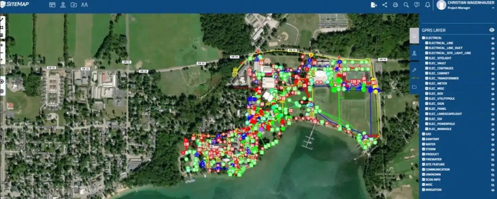
Advanced data visualization and analytics tools enable organizations to gain actionable insights from vast amounts of data. According to studies, 80% of organizations find that more accurate decisions are made when using visualization tools. Beyond that, 86% of companies report faster decision making through data visualization. SiteMap® offers comprehensive reporting and visualization features, allowing organizations to analyze, interpret, and communicate complex data effectively, supporting informed decision-making and stakeholder communication. The Digital Map Room is just one example of how we use visualization to help properly and easily navigate and represent your subsurface data.
The Role of SiteMap® in Shaping the Future of Infrastructure Asset Management
SiteMap® is in the thick of innovation in infrastructure asset software development, incorporating cloud-based deployment, digital twin technology, and advanced data visualization and analytics capabilities, and more. By embracing some emerging trends, SiteMap® empowers organizations to unlock new opportunities, optimize asset performance, minimize risks, and drive sustainable growth in a rapidly evolving business landscape. With SiteMap®, organizations can navigate the future of infrastructure asset management with confidence, harnessing the power of technology to map tomorrow and beyond
SiteMap® not only utilizes modern trends, but we also create them. We lead the way to innovation, while also carefully keeping check of our accuracy and overall ease of use. Sitemap works as a multifunctional application, offering unique capabilities. Some of those capabilities include:
- Infrastructure management
- Infrastructure mapping
- Utility cloud mapping
- Utility management
- Mapping software
- Geospatial solution
- GIS mapping
- Digital map viewer
- GPS software
- Geospatial mapping
This study is one of many examples supporting the fact that as subsurface management software and technology, requires a stance of a multifunctional resource requiring careful planning and sensitive management in accordance with its potential and value to society. Utilization of the different subsurface technology requires careful planning and a framework to support decision-makers in achieving a balance between utilization and preservation, and between the subsurface functions themselves in the case of outright utilization. SiteMap® manages to do this, and more.
The GPRS Difference
SiteMap® isn’t your typical infrastructure management software, it’s backed by GPRS, which is the nationwide leader in subsurface locating and mapping, offering a 99.8% accuracy rating across 500,000 jobs nationwide.
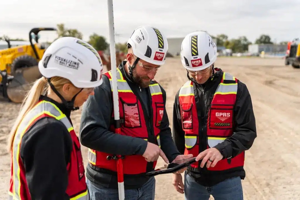
GPRS is in pursuit of 100% subsurface damage prevention. Our 99.8% accuracy rate demonstrates that our equipment, training, and methodology consistently deliver high-quality results nationwide. All 500+ GPRS Project Managers utilize the industry-leading specification called Subsurface Investigation Methodology (SIM) when conducting utility mapping, concrete scanning, sewer camera inspection, or 3D laser scanning.
GPRS’ field-to-finish process is underpinned by our 99.8% accuracy rate. Our skilled Project Managers employ various collection devices such as ground penetrating radar, electromagnetic induction, CCTV crawler cameras, LiDAR, and acoustic leak detectors to gather built world data. This data is then compiled into deliverables by our in-house Mapping and Modeling Team.
These maps and models can be stored within the digital plan room of SiteMap®. Upon completion of a private utility locate service, our field data automatically creates a map of your site and is delivered in various file formats such as .pdf, .kmz, and .shp. This field-to-finish solution is also delivered through a free subscription to SiteMap®.
This comprehensive collection and management service is unlike any other on the market, and is only available through GPRS and through SiteMap®. So, SiteMap® isn’t just watching and following certain trends, SiteMap® is creating a new way to see and manage the subsurface, right down to creating new proprietary technologies that shape the way utility data collection is managed.
SiteMap® offers organizations a complete and comprehensive solution for navigating the complexities of infrastructure management with precision and efficiency. By embracing certain trends and leveraging the capabilities of SiteMap® and GPRS, organizations can map tomorrow with confidence, while seeing the subsurface in a way that they’ve never seen before. SiteMap® is more than just a management tool, we act as a window into the world of the subsurface. With SiteMap®, you can see the subsurface clearly and simply.
Contact us today to learn more about how we can help you map the future of your city.