Japan stands as a global leader, renowned for its cutting-edge technologies and innovative approaches to optimizing urban environments. With Japan’s government pumping over $2.3 billion per year into their universities and science programs, it’s no wonder that they stand strong as an innovative nation. One such groundbreaking initiative is the ROADIC System (Road Information Management System), a sophisticated platform developed by Japanese authorities to enhance the efficiency, safety, and sustainability of transportation infrastructure across the country. ROADIC isn’t new to Japan, but it is to most of the world because the technologies it studies and utilizes are constantly changing and improving, much like Japan itself.
SiteMap® (patent pending) powered by GPRS, is a premier infrastructure mapping solution, which operates similarly to the ROADIC System for private customers. Both technologies represent an evolution in infrastructure management, leveraging advanced 3D mapping and underground facility management capabilities to drive unprecedented levels of efficiency, effectiveness, and reduce reworks across in our world’s infrastructure network.

Japan’s underground infrastructure, particularly in urban areas like Tokyo, is extensive and innovative, featuring complex networks of subways, tunnels, and underground shopping districts that efficiently serve the needs of millions while mitigating congestion above ground.
The ROADIC System: Redefining Infrastructure Management in Japan
The ROADIC System serves as a comprehensive platform for managing Japan’s extensive network of roads, bridges, tunnels, and underground utilities. Developed by the Japanese Ministry of Land, Infrastructure, Transport and Tourism (MLIT), the system provides centralized access to a wealth of infrastructure data, including road conditions, maintenance schedules, traffic flow, and underground utilities. By consolidating disparate datasets into a unified platform, the ROADIC System empowers government agencies, infrastructure operators, and urban planners with actionable insights and analytics to optimize infrastructure planning, maintenance, and development initiatives.
The History of ROADIC
The Road Administration Information Center (ROADIC) was created in 1986 as a result of several large-scale gas explosions that killed and injured hundreds of Japanese people, while causing tremendous damage. The gas line explosions and the need to coordinate road construction, coupled with available funding at the ministry level, lent significant impetus to the formation of ROADIC. The Japanese national government saw the need to develop an approach to preserve public safety and to improve response to accidents involving this significantly expanding public energy source. It took the lead to organize ROADIC through its Ministry of Construction, Bureau of Roads, which proactively enabled the foundation of the program in 1986.
As a collection of public and private members, ROADIC was set up as a national project in order to manage and protect the public utilities within the right-of-way. Following a successful initial implementation in metropolitan Tokyo in the mid-1980s, additional branches have been integrated within 12 major urban centers throughout Japan. Some of these cities include: Tokyo (23 separate Wards), Sapporo, Chiba, Kawasaki, Yokohama, Nagoya, Kyoto, Osaka, Kobe, Hiroshima, Kitakyushu and Fukuoka. These 12 branches coordinate with local government agencies and public utility companies including electric, gas, water, sewer, trains, subways and communications.
The original cost of establishing the ROADIC program was in the range of ¥ 9.5 billion, or $8.7 million U.S. 60% of this cost was funded by the national government. The remainder was contributed by interested local governments and utility companies. In 2003, the annual operating budget was ¥ 3.4 billion, or approximately $3.1 million U.S. The Japanese national government provides 50% of the annual operating funds. Both taxpayers and ratepayers are supporting ROADIC operations.
ROADIC Study Missions
In early 1990, the Geospatial Information & Technology Association, then known as AM/FM International, established an affiliate of the association in Japan. At the outset of this relationship, ROADIC became interested and involved in the activities of the Japanese affiliate. Several of the original founders of ROADIC were also instrumental in the creation and development of GITA-Japan. In addition, many geospatial professionals from Japanese utilities, government agencies and private sector companies began to take part in GITA’s annual conference in the United States.
As things evolved, ROADIC began to capitalize on the conference, using the technical educational program as a forum for identifying specific implementations of geospatial technology that were of interest to the organization at the time. ROADIC began to organize “study missions” to North American utilities, cities, other government agencies, and private sector companies. As GITA was also active in Europe, visits to European utility and government organizations were also included, and a pattern of alternating trips to North America and Europe every other year emerged. This allowed for host nations to have a free exchange of geospatial infrastructure management solutions with the Japanese professionals, ensuring continued improvements and refinements worldwide.
The missions are typically held in October, and they have occurred every year since 1990, with the exception of 2001 due to complications from the 9/11 terrorist attacks. The ROADIC delegation typically consists of 12-18 individuals representing Japanese utility organizations, government agencies and private sector service providers. A list of questions about each site is prepared. During the on site tours, a Japanese translator ensures that all important points about a project or implementation are understood and assists the group. Individual opinions and impressions are analyzed and a summary report is made of each site visit. After returning to Japan, the information is further processed and studied and the ROADIC system adjusted to include any particularly worthwhile ideas obtained from the host sites.
Due to this unique system of on-site learning, continuous system improvement has been implemented and celebrated. These ventures have made the ROADIC system of Japan a world-class example of multi-organizational cooperation and information sharing.
Similarly SiteMap®: Unlocking the Power of 3D Mapping and Underground Facility Management
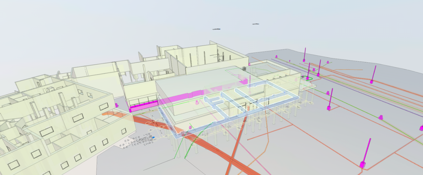
An example of a GPRS 3D map with a detailed visualization of underground utilities and infrastructure, providing accurate spatial data for navigation and construction planning in urban environments.
At the heart of the ROADIC System’s capabilities lies technology that is also used by GPRS, and therefore, SiteMap®, a state-of-the-art infrastructure mapping solution renowned for its advanced 3D mapping and underground facility management functionalities. Similarly, should they wish to, by incorporating SiteMap® into the ROADIC System, Japanese authorities could gain access to a suite of powerful tools and features that may enhance the system’s effectiveness and efficiency.
Comprehensive Infrastructure Mapping
SiteMap® enables the creation and delivery of detailed existing conditions and 3D maps of an infrastructure network, providing stakeholders with a comprehensive view of roadways, bridges, tunnels, and underground utilities. This detailed mapping data serves as a foundation for informed decision-making, allowing authorities to identify potential bottlenecks, optimize traffic flow, and prioritize infrastructure investments.
Advanced Visualization Capabilities
SiteMap®’s advanced visualization capabilities empower users to interactively explore and analyze infrastructure data in a virtual environment. By visualizing complex infrastructure networks in 3D, stakeholders can gain insights into spatial relationships, identify potential conflicts, and assess the impact of proposed projects on existing infrastructure assets.
Efficient Underground Facility Management
Managing underground utilities is a critical aspect of infrastructure maintenance and development, particularly in densely populated urban areas. SiteMap®’s underground facility management capabilities enable municipal managers and authorities to accurately map, monitor, and maintain underground utilities, minimizing the risk of damage during construction activities and improving overall infrastructure resilience.
Data Integration and Collaboration
SiteMap’s data portability allows it to work well with existing infrastructure methods and systems, enabling interoperability and data sharing across different government agencies and stakeholders. This supportive approach streamlines workflows, enhances collaboration, and fosters data-driven decision-making, leading to more efficient and effective infrastructure management practices. While SiteMap® offers its own GIS platform, it’s easy to utilize with other platforms as well.
SiteMap® allows customers to visualize their underground infrastructure in much the same way as Japan’s data system, with accurate as-built data.
When you hire GPRS, your subsurface utilities are located, mapped, and layered in our interactive geospatial platform that allows you to deconstruct your utility map, as well. And because it’s cloud-based, SiteMap® is secure, accessible 24/7, and shareable with those you designate for as long as they need the information.
Extra Savings

Because GPRS services support SUE QL-B, you could achieve significant savings by greatly reducing potholing, utility strikes, and the cost overruns usually associated with construction, expansion, or infrastructure installation by having 24/7 access to GPRS 99.8%+ accurate subsurface information via SiteMap®.
The continued cost savings of digitizing and aggregating your underground utility maps has not been studied in significant numbers, but a recent case study cited in the Common Ground Alliance’s 2022 DIRT Report showed that the city of Chicago reduced its underground utility strikes by 50% over a five-year period by creating accessible aggregated utility maps in a GIS platform.
So, by utilizing SUE Standard A or B to locate and accurately map subsurface utility and infrastructure data, general contractors, facility managers, stakeholders, and municipalities could slash project costs by 9% – 40%.
Similar Cases
SiteMap® creates an accurate single source of truth for your entire team. Backed by the amazing 99.8% accurate data provided by GPRS, SiteMap® functions as a one stop shop for everything subsurface. Much like ROADIC, SiteMap® utilizes the finest technology to accurately and simply map the world below your feet. Other nation’s have accomplished similar efforts:
Sarajevo, Bosnia
Over 40 years ago, Sarajevo mandated the recording of the location of all utility and telecommunications infrastructure data in the city. This was originally done manually on paper maps, much like in other countries. However, several years ago Sarajevo began converting these maps to digital format which run on Oracle Spatial.
Calgary, Alberta
Many years ago the city passed a by-law which mandated that all utilities and telecoms working within city limits must provide data showing the geolocation of their infrastructure. This data would have to be reported to the city’s Joint Utility Mapping Project (JUMP). JUMP provides a single-source database which shows the geolocation of all underground utilities.
São Paulo, Brazil
The City of Sao Paulo’s GeoCONVIAS project integrates data from 20 to 30 utilities which operate in the city of Sao Paulo.
Rio de Janeiro, Brazil
The City of Rio de Janeiro has a similar project GeoVias funded by the government of the City of Rio de Janeiro and four utilities, as well as a project to monitor offshore seismic activity.
The ROADIC System represents a landmark achievement in Japan’s ongoing efforts to enhance the efficiency, safety, and sustainability of its infrastructure network. Despite the integration of 811 in the USA, SiteMap® stands as a leader in subsurface mapping, similar to the ROADIC System. By leveraging advanced 3D mapping and underground facility management capabilities, the ROADIC System empowers authorities with unprecedented insights and analytics to optimize infrastructure planning, maintenance, and development initiatives. SiteMap® offers the same innovative process and technology that ROADIC is celebrated for, changing the way we view the subsurface one city at a time.
Are you looking to see the subsurface? Contact SiteMap® today.