Imagine a forest so dense that ferns grow up and tickle your calves, and the light only filters through to sections of land that the trees allow it to grace. You’re in a capsule of green, lonesome birds, trees, and water, where the world is silently buzzing below and around you. Such a place is The Hoh River Valley. It exists deep in Washington’s Olympic National Park, and it just may be one of the last “Silent Places” left in the U.S.
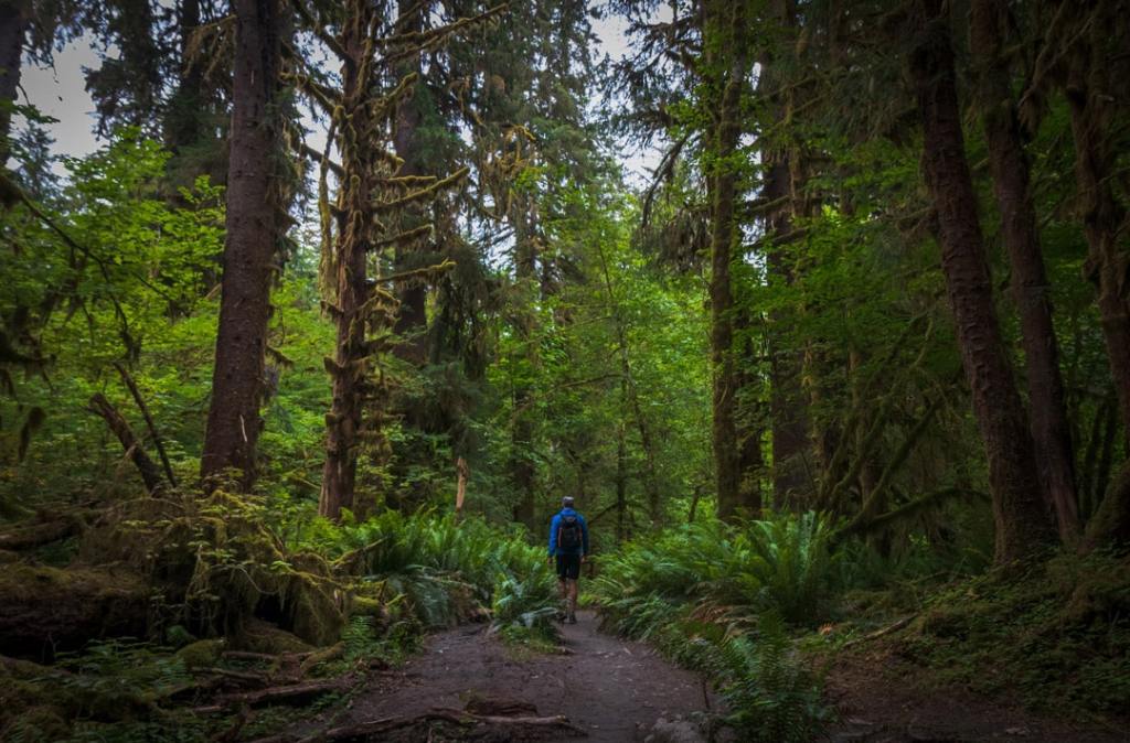
There are only 12-15 “Silent Spaces” left in the U.S
A silent place is somewhere where you can experience complete silence for at least 12-15 minutes uninterrupted. These places are important because there are only 10-12 left in the U.S., and understanding our subsurface infrastructure helps us keep them.
When we’re able to correctly map the facilities below our ground, we’re able to properly plan our telecommunication fiber lines, our generators, substations, and transmission lines, our roads, highways, by ways, and everything else that exists opposite of these “Silent Spaces.” To help preserve the yin, you must also take care of the yang. SiteMap® makes understanding the less quiet spaces of our world much easier to do, but how?
SiteMap® Keeps It Simple
SiteMap® offers a convenient way to experience facility and location data. This geospatial solution functions as a digital storage platform for your, your as-builts, maintenance records, permits, and your tagged, cached, and layered maps. GPRS has hundreds of thousands of data points, celebrating an accuracy rating of 99.8% across more than 500,000 utility locating and concrete scanning jobs, and provides millimeter-accurate 3D laser scan data. Thousands of new data points are added daily.
SiteMap® grants each user a unified view of their information, whether the job is large or small. SiteMap® helps keep your infrastructure data management simple, with aggregated site data available easily and simply, geolocated, layered, and securely shareable all within an intuitive user interface. Some tiers are even able to view historical information, as well as add their own data to help create a fuller picture of the site at hand.
Why use SiteMap®?
SiteMap® is one the one-stop subsurface GIS solution, offering numerous benefits to users of all tiers, including:
- Access to your Digital Plan Room, making information access easy
- Store all your data in one source of truth, making it easy to review and keep
- Utilize the user-friendly interface and GIS system
- Tap the power of GPRS technology & services: a 99.8% accuracy rating
- See all your data: whether historical or current, layered and tagged for easy view and interaction
- Receive a permanent record of site assets
- Secure cloud-based storage, give access only to those who need it.
- Upload and store as-builts drawings and site records.
- Attach supporting files, such as videos, photos, GPR data, and documents.
- Access to GPRS data, often within five minutes after project completion
Perhaps the best benefit of SiteMap® is the connection to GPRS, which is the largest private utility locator in the United States. GPRS holds on of the most comprehensive collections of utility information, giving users access to the most accurate and current maps and facility information.
SiteMap® offers multiple capabilities, some of these include:
- Infrastructure management
- Infrastructure mapping
- Utility cloud mapping
- Utility management
- Mapping software
- GIS mapping
- GPS software
- Geospatial mapping
And more.
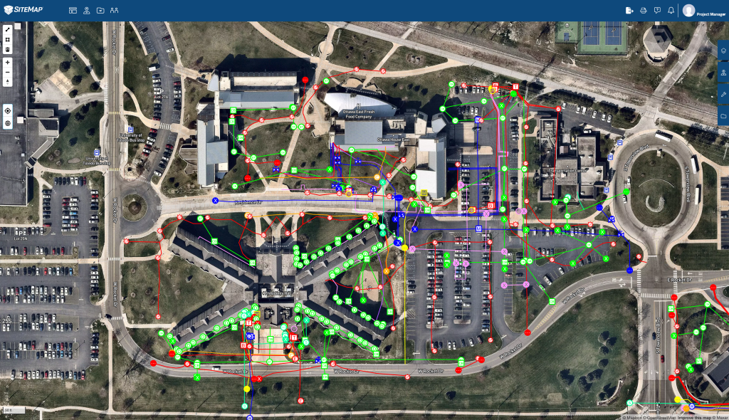
A plan view showing a layered SiteMap utility map over a drone image
Starting With SiteMap®
When a user orders a utility locate job from GPRS, they are automatically granted access to a complimentary SIteMap® account, they are also given the option to upgrade to unlock more comprehensive features. Whether the job is for a university or a transportation project, or something in between, they can expect the same great level of data and accuracy that is always delivered with GPRS.
After the GPRS job is completed, the data will then be uploaded to SIteMap®, often within five minutes of job completion. Users have access to all their GPRS data, making it easy to stay informed in real-time about the world below their feet. This level of quality saves time and money, ensuring a better project outcome for the user.
In fact, according to a study by Stevens, R.E. in 1993, titled Society of American Value Engineers, General Percentages of Cost Savings, the total savings on a typical project using quality level B and A data may range from 10% to 15% compared to a project using a lower quality level of data. GPRS offers A level quality data, which is both comprehensive and accurate. According to this paper, the approximate cost of savings as a percentage of project are:
- Administrative (1/10 of 20%) 2.00%
- Engineering (1/20 of 10%) 0.50%
- Utility relocation (1/2 of 10%) 5.00%
- Construction (1/20 of 45%) 2.25%
- Cost Overruns (1/3 of 15%) 5.00%
While that study was 30 years ago, the data quality needs are more relevant than ever, offering a higher cost savings than before. Other studies have also shown that costs were higher for urban projects versus rural projects. When you choose SiteMap®, you choose quality, you choose accuracy, and you choose savings.
The Next Step of SiteMap®
Once you register for your complimentary SiteMap® account, you’re able to view all the data GPRS has provided you to complete your project, no matter how complex it is. SiteMap® gives you accurate data in a customizable, budget-friendly, and intuitive way that updates in just minutes. With your account, depending on your subscription level, you’ll enjoy great benefits like:
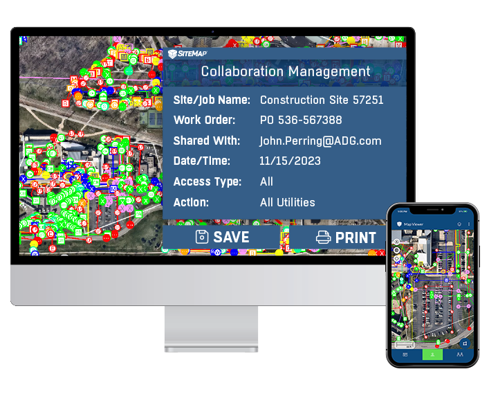
SiteMap is a cloud-based application that houses your GPRS data and is accessible from a computer or mobile device
Digitally Organized and Secured Files
The Digital Plan Room acts as your data hub. From here, facility managers, general contractors, and stakeholders can see every file and map on any GPRS locating job. This means you’ll have access to a digital vault of all the data you could ever want, and all of it is hyper-accurate, more accurate than any other utility locating company can provide.
Easily Searchable and Shareable
The Map Viewer allows you to eliminate most of the confusion in communications by stripping away all the layers that your contractors don’t need to see. This allows you to show them exactly what they need to see, and when they need to see it. This data is searchable, securely shareable, and accessible with no extra knowledge or training. SiteMap® is designed with the user in mind, while understanding that not everyone has an engineering degree.
Informational Layers & Aggregation
All your subsurface infrastructure data can be easily aggregated, located, and cross-referenced. This provides a single source of truth for your team, reducing risk of damages and miscommunications. Further, depending on your subscription, you may also be able to add historical data, or additional data of your own. This data is then layered and made easily viewable, just like the data provided by GPRS. With your data offered in such an easy-to-read manner that can be updated as needed, it ensures that your subsurface as-builts are accurate, ready to see you through planning, prefabrication, construction, and even operations & maintenance.
When You Get Started
Signing up for SiteMap® is just as easy as using it. Once you order your GPRS utility location & mapping job, you’ll be sent information on how to register for your account. Once you’ve signed up, your data will appear as soon as it’s ready.
Unsure of where to go or what to do? When you log in, you’ll find that you have access to tutorials and other useful guides that will help guide you around your SiteMap® subscription with total ease. If you still need extra help, you’ll find that SiteMap® offers a responsive, helpful, and friendly Customer Service Team that is there to answer any of your questions. However, we’re confident that after just a few moments looking around, you’ll understand how to use SiteMap® as the ultimate facility infrastructure management source that it’s meant to be.
Your data is safe with SiteMap®, and is stored forever, meaning that you’ll never have to worry about lost papers or files again. Depending on the tier of subscription chosen, the data you access and how you access it may change. However, your data is safe, easily searchable, and easily shareable. Get the data you need, when you need it, without the hassle that a huge filing cabinet offers. Your filing cabinet may be an eyesore, but SiteMap® is an eye-opener instead.
Getting started with SiteMap® is easy, and the data powered by GPRS is the most accurate on the market. If you’re looking for an easy solution for facility asset visualization, streamlining your project and lowering the risk of a detrimental accident, then SiteMap® is for you. In the world, there are parallels, there’s the hard way, and then there’s the SiteMap® way. View the world in a new and exciting scope, view it with SiteMap®. Contact us today to hear more about how we can help you manage your facilities, and beyond.