The electric power industry is preparing for up to a tripling of US electricity demand within the next few decades. This means that there will be more facility managers in need of accurate data to help manage and lead this growth. SiteMap® (patent pending) stands as a leader in the geospatial arena, helping power and telecom facility managers throughout the nation. Created with the user in mind, SiteMap® offers a powerful tool for revolutionizing facility management for various fields, taking a complex, yet important task and simplifying it. When you can present your data in bite-sized pieces, anyone can understand it, even those who may not have extensive experience or training. SiteMap® simplifies facility management, workflows, and communications. Here’s how.
Enhanced Facility Tracking and Management
One of the key advantages of SiteMap® Geospatial Solution is its ability to track and manage facility infrastructure effectively. Depending on your subscription level, your team can easily access both current and historical data, aggregated, tagged, and secure. By utilizing layered, comprehensive geospatial data, businesses can monitor the location, condition, and maintenance history of utilities and structures in real time. This enables proactive maintenance, reduces downtime, and improves overall asset utilization.
SiteMap® offers more than just utility mapping services and proves to be one of the most comprehensive, easy-to-use, and accurate platforms for utility tracking, management, and safety. This helps keep your facility managers on the same page with their workers, leading to less risk and greater success.
Streamlined Maintenance and Repairs
Facility maintenance is a critical aspect of facility management. SiteMap® simplifies this process by providing a visual representation of the facility’s layout, above and below ground. This allows facility managers to figure out where changes have occurred, track installation dates, identify maintenance needs quickly, schedule repairs efficiently, and minimize disruptions to operations.
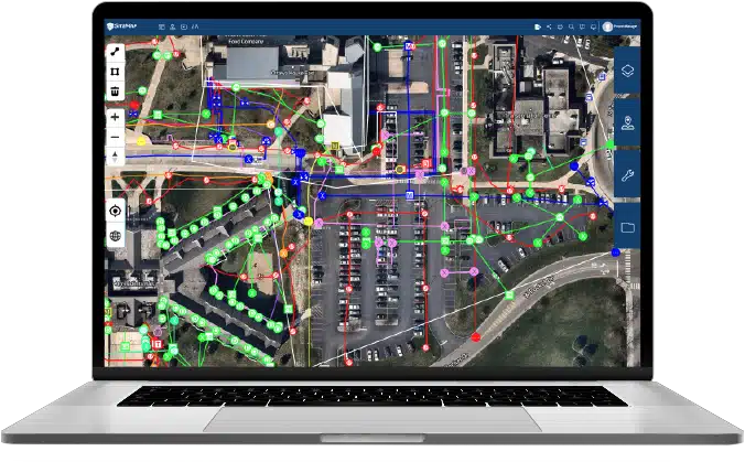
This data is represented in SiteMap® Map Viewer, which shows your data in an easily digestible format. In your Map Viewer, your site will appear in a satellite image that looks like Google Maps, but better. From there, your data will be represented on different layers, using different lines and colors, links to interactive video reports, 3D photogrammetry, and even 3D BIM models, if applicable. To learn more about any utility facility feature on your map, just click. Additional data will appear for all the work GPRS has done to visualize your facility. This means that anyone of any knowledge level can utilize the data, streamlining repairs and maintenance at all levels.
Optimal Space Utilization
Efficient space utilization is essential for maximizing productivity and reducing costs. SiteMap® offers insights into space usage, accurate measurements, and other important aspects regarding the location around your data points. You can even measure within the application itself, even if you are not on site. By analyzing GPRS’ accurate spatial data, facility managers can optimize space allocation, improve workflow, and enhance overall operational efficiency. SiteMap® gives you a clear view of your project’s space, facility managers can better plan, prepare, and understand the spatial needs of their projects. This helps to create a streamlined and fluid project management experience.
Enhanced Safety and Security
Maintaining a safe and secure environment is paramount in facility management. SiteMap’s utility & infrastructure mapping app enables real-time monitoring of critical areas and utilities. This ensures compliance with safety regulations, facilitates emergency response should there be one, and mitigates potential risks. When facility managers can accurately see the utilities that they need to be aware of, it’s much less likely that a strike or other incident will occur. Considering that there were 213,792 unique reported damages for 2022, according to the 2022 DIRT report, this safety is more important than ever. Incidents are on a three-year rise, with telecommunications and natural gas being the facilities most frequently damaged in 2022. Telecommunications work led to the most damage. Water, natural gas, sewer, and electric work followed.
The better grasp facility managers have on the data that they should be monitoring, the better things turn out and the less risk there is to everyone involved. By utilizing SiteMap®, facility managers can increase their safety and security, which also lowers their chances of receiving costly OSHA violations.
Seamless Integration and Scalability
While SiteMap® has its own GIS component, it also works with your existing GIS software, making it easy to implement without disrupting ongoing operations. Additionally, it offers scalability, allowing businesses to expand their facility management capabilities as their needs evolve.
Critical data can be lost far too easily across outdated platforms. SiteMap® creates an aggregated, historical, single source of truth – with above and below ground as-builts, updated as often as you need for as many sites as you need – to eliminate data loss and the costly mistakes that come with it.
SiteMap’s greatest strength is its flexibility. Examples of information a user can view and store include:
- Utility layouts
- As-built drawings
- 3D models
- Floor plans
- Structural drawings
- Subsurface void information
- Drone Imagery
- Sewer and manhole video inspection data
- Underground storage tank information
- Aboveground storage tank informatio
The SiteMap® tool allows users to manage and customize their data according to their needs. The scalability of the SiteMap® system is one way we accomplish this. As more information becomes available, the system can grow with the user. Additionally, SiteMap® can export data to other systems and is built for integration.
SiteMap® offers a geospatial solution for facility managers that is unparalleled by any other on the market. From easy-to-understand maps to scalability to the 99.8% accuracy rating backed by GPRS, there’s a lot that can be monitored with SiteMap®. SiteMap® is revolutionizing facility management by leveraging geospatial data to optimize processes, streamline maintenance and communication, improve space utilization, and ensure safety and security. By adopting this innovative technology, businesses can achieve greater operational efficiency, reduce costs, and provide a seamless project experience. Embracing such advancements in facility management is crucial for staying competitive and safe in a world where incidents are on the rise and project security is crucial.
To learn more about how SiteMap® can help elevate your facility management experience, contact us today.