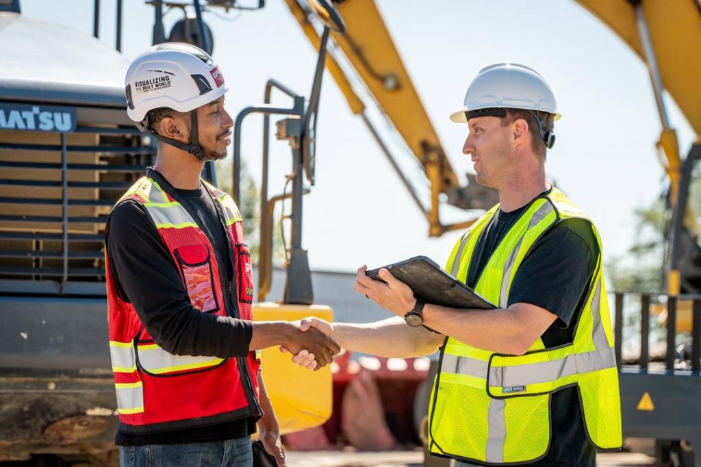
The management of our cities and towns, interwoven with IT advancements, is becoming more complex than ever before. From buried lines to a complex web of fragile utility assets, both above and below ground, the delicate dance to manage these infrastructure assets plays a crucial role in ensuring the efficiency, reliability, and sustainability of organizations and our growing subsurface infrastructure. With the growing complexity of infrastructure systems and the increasing reliance on technology, organizations are turning to advanced solutions like SiteMap® (patent pending), powered by GPRS, to streamline their asset management processes. Let’s focus on how SiteMap® utilizes advanced mapping and visualization techniques to map the subsurface
Understanding Infrastructure Asset Management
Infrastructure asset management involves the planning, acquisition, operation, and maintenance of physical assets such as buildings, utilities, transportation networks, and IT systems. Effective facility asset management ensures that these assets are utilized optimally, maintained efficiently, and aligned with organizational goals and objectives.
Infrastructure asset management (IAM) is a system for sustaining public infrastructure systems through their entire life cycles, of critical infrastructure and physical assets. Important systems such as wastewater treatment plants, telecommunications, sewers, roads, utility grids, transportation systems, and more, are all managed through infrastructure asset management. In 2022, the United States spent more than $36 billion on infrastructure projects, transferring another $94.5 billion to state governments.
The infrastructure asset management process is a complex system of components and practices, including:
- Asset inventory
- Condition assessment
- Level of service (LOS)
- Life cycle costing
- Risk management
- Long-term financial planning
Use Cases
A range of industries in the public and private sectors rely on IAM to get the most out of infrastructure assets. Some use cases for IAM include:
- Municipalities and cities
- Utilities
- Transportation
- Energy
- Healthcare
- Educational Centers
- Data Centers
- Waste Management
The Future
There are many advanced and complex technologies which can help automate and enhance various aspects of IAM. For example, a geographic information system (GIS) captures, stores, analyzes, and visualizes geospatial data. This data includes things like maps, satellite imagery, aerial photographs, survey data, and so on. Integrating GIS with IAM systems adds an element that was previously unattainable, this element being spatial context. This helps managers better understand the relationship between assets, the location, and the surrounding environment.
It is important to note, however, that most GIS platforms are limited to only the as-built and existing conditions data uploaded by the user as their “capture” method, and most of that documentation is inaccurate and outdated. Only SiteMap® provides professionally captured above and below-ground infrastructure data, courtesy of GPRS and our 500 pairs of “boots on the ground” Project Managers deployed in every major U.S. market and trained to provide the most accurate and accessible facility and infrastructure data possible.
IAM is important to ensuring sustainable, efficient infrastructure asset usage. The field is set to become even more sophisticated as it paves the way for smarter, more resilient infrastructure systems that serve us well into the future. GPRS is a fine example of how new technologies can be used to help manage our infrastructure. With SiteMap® being the missing puzzle piece that was needed to accurately view the big picture.
Challenges in Subsurface Mapping
Mapping the subsurface presents unique challenges due to the concealed nature of underground utilities and infrastructure. Traditional methods, such as manual surveys and excavation (potholing), are time-consuming, costly, and often inaccurate. Moreover, the subsurface environment is dynamic, with utilities constantly being installed, repaired, and replaced, making it difficult to maintain up-to-date records of underground infrastructure.
The Role of SiteMap® in Subsurface Mapping
SiteMap® offers a comprehensive solution for subsurface mapping, leveraging advanced mapping and visualization techniques to accurately map underground utilities and infrastructure. SiteMap® offers a wide variety of methods and benefits to help aid proper subsurface mapping and asset management.
High-Resolution Mapping:
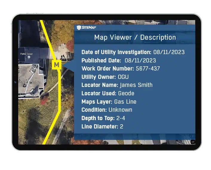
SiteMap® provides high-resolution mapping capabilities, enabling organizations to create detailed maps of underground utilities with unprecedented accuracy. By accurately depicting the data you need, such as location, depth, and type of underground utilities, SiteMap® helps organizations minimize the risk of utility strikes, damage, and service disruptions during construction activities. The Digital Map Viewer is the central hub of SiteMap®, allowing users to interact with carefully visualized and aggregated data sourced by GPRS.
Advanced Visualization Techniques
SiteMap® utilizes advanced visualization techniques, such as 3D modeling and reality capture, to create immersive and interactive representations of underground infrastructure.
By visualizing underground utilities in 3D, SiteMap® allows users to explore the subsurface environment from different perspectives, enabling better spatial understanding and decision-making. Using GPRS, you can document construction progress with ProCap Progressive Capture, which utilizes 3D photogrammetry to track the evolution of the site and document key project milestones. Virtual tours like WalkThru 3D allow you to virtually walk-through a site or facility in minutes, take basic measurements, estimate clearances and distances, and add digital notes.
GIS Data Portability
While offering its own, SiteMap® also offers seamless data portability with many other GIS platforms, allowing organizations to overlay underground utility maps with other spatial datasets, such as land use, topography, and environmental existing conditions.
By combining GIS data with subsurface mapping, SiteMap® enables organizations to analyze spatial relationships, identify potential conflicts, and make informed decisions about infrastructure planning and development.
Best Practices for Subsurface Mapping with SiteMap®
Data Collection and Validation:
GPRS is in pursuit of a world with 100% subsurface damage prevention. Our 99.8% accuracy rate for ground penetrating radar services (GPR), utility locating services, utility mapping services, and concrete scanning services will locate critical targets like underground utilities, post tension cables, rebar, conduits, underground storage tanks (USTs), and more to help keep your project on time, on budget, and safe. Our NASSCO-certified CCTV video pipe inspection & leak detection services find pipe defects, blockages, and leaks with pinpoint accuracy.
Utilize Advanced Mapping Features:
Take advantage of SiteMap’s advanced mapping features, such as high-resolution mapping and 3D visualization, to interact with detailed and immersive representations of underground infrastructure.
GPRS provides complimentary KMZ and PDF maps and a SiteMap® Personal Subscription with every utility locate performed. Our Mapping & Modeling Team can create anything from a simple GPS-enabled locating map of your utility locate, to highly-detailed 2D CAD drawings and 3D BIM models, depending on your needs.
GPRS customizes every job quote to meet your needs and provides complete GPS-enabled documentation of your maps and models via SiteMap®. All data, maps, and models are quickly delivered via file sharing platforms and SiteMap®.
Integrate Your GIS Data
SiteMap® provides instant data portability with other GIS data sources to overlay subsurface maps with other spatial datasets, enabling deeper analysis and insight into infrastructure assets.
IT is in charge of the next wave of infrastructure asset management. Keeping up with the technology and methods to accurately and smartly manage this complex, growing web isn’t easy. Yet, this practice is essential for organizations looking to optimize their infrastructure management. With SiteMap®, organizations can overcome the challenges of subsurface mapping by leveraging advanced mapping and visualization techniques to accurately map underground utilities and infrastructure. Access 99.8% accurate data, in the best way possible, with Intelligent Visualization and digital portability offered by GPRS. By following best practices for subsurface mapping with SiteMap®, organizations can streamline their asset management processes, seeing the subsurface in a new, simpler, better way.
Contact us today for more information on how to advance your asset management practices with SiteMap®.