What if you held data in your smartphone, your computer, or your tablet that could carefully map where one of the first sewage systems in your town once existed? Depending on the data, and what remains, mapping our history like this is a very real application of GPR.
GPRS’ new technology, SiteMap® (patent pending) makes finding long-forgotten and abandoned utility lines, water pipes, and sanitary sewer lines possible. Because GPRS customers hold a powerhouse of possibility with their SiteMap® personal subscriptions; you can see the precise location of any utility line, meaning that even digging for anything from a new high-rise foundation to grandma’s new flower garden won’t interrupt electrical service for an entire neighborhood block. Your possibilities for control and safety are nearly endless. For instance, in the realm of ground penetrating radar (GPR) and other effective technologies and systems, you can harness the full visualization power you need for project success. That’s what SiteMap® does best. With a SiteMap® Personal subscription, users gain access to an innovative offering that empowers construction, architectural, and engineering professionals, and facility managers alike.
What is SiteMap® Personal?
SiteMap® Personal is a comprehensive facility and infrastructure visualization and data management software platform that offers a plethora of features and tools tailored to meet the needs of users who require GPR and other subsurface technologies for utility locating and subsurface visualization: be it in the construction industry, facility or municipal management, or any other field that relies on subsurface investigation. Even the archaeology field can benefit from GPR and a SiteMap® subscription, as GPR has been shown effective at locating where the earliest remnants of your town began and where modern and historical infrastructure intersect.
Every client who hires GPRS is given a complimentary SiteMap® Personal account.
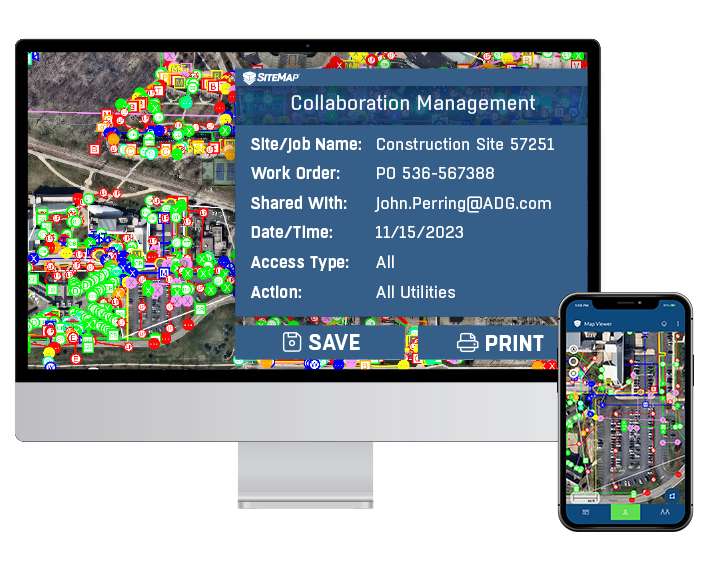
With your Personal subscription, you’re given access to a portal where all your GPRS data is housed. This portal can be securely shared with your team and accessed via your favorite computer or mobile device. In SiteMap®, you’ll have the option to view your data in layers, customize your experience, and more. We provide complimentary KMZ files and PDF maps with every utility locate we perform, and you will also find these in the platform. Your SiteMap® Personal account is a one-stop shop for infrastructure asset management.
With a SiteMap® subscription, users have a convenient way to experience facility and location data. As a geospatial solution, it can also function as a digital storage platform for blueprints, as-builts, maintenance records, permits, and much more. Depending on your tier, you may be able to upload your own documents, but all will allow you to view data GPRS provides. SiteMap® can become the assistant, the archivist, and the researcher you always wanted.
Key Benefits
There are innumerable benefits to having a Personal SiteMap® subscription> Some of these benefits include:
Efficient Data Management
SiteMap® Personal simplifies the organization and management of your project and site data. Users can easily see, interact with, store, and share their project data from any device, streamlining their workflows, saving valuable time and space. The intuitive and easy to use user interface can operate as a permanent record of site assets, depending on your subscription level. Poor data management reduced operational efficiency by 21%, This is why having an efficient data management solution & GIS platform is important in our modern world.
Advanced Data Analysis
Foster collaboration and communication within your team, creating a habit of connected construction. The importance of data in building the world around us is greater than you may believe. This is especially true when it comes to our utilities. A study conducted by AWWA found that when it comes to assessing pipe conditions, 63% of utilities are at least somewhat engaged in the practices of using GIS management software; while about half of those are using historic break data as their basis, only 13% are using advanced conditions or techniques. AWWA also discovered that utilities using GIS management tools experienced a 30% reduction in the usual duration of water service interruptions.
The more advanced your data analysis is, the better you’ll understand the subsurface, and the better you’ll be able to plan, solve, and build the world above and below. Better data analysis leads to efficiency, progress, and even increased safety. We strive to provide a comprehensive data platform to fuel advanced data analysis among your teams.
Sometimes, breaking down your data into sections provides the best view. GPRS helps with this by using Video Pipe (CCTV) Inspection, among other valuable data gathering methods. Our NASSCO certified Project Managers can locate clogs, investigate cross bores, find structural faults and damages, and conduct lateral sewer line inspections. All GPRS VPI Project Managers are NASSCO trained and certified and provide interactive WinCan reports for our pipe inspections. These reports, including video files and photos, can be housed and accessed in SiteMap®.
Easy Collaboration
When you order GPRS services, you’re given access to a SiteMap® account that holds all the data that was collected regarding your project. This may include things like interactive 3D utility mapping, real-time subsurface data, as-builts, and more, depending on your needs. This data is easily accessible, but it’s also easily shared with anyone on your team. You’re able to share access quickly and efficiently to this platform. No extra training or knowledge is needed to understand the data – meaning that anyone on your team will be able to utilize it – especially in the field.
Collaboration is important, so important, in fact, that even the thought of collaboration has an impact on our psyche. A study by Stanford found that even the mere cue of working together increases intrinsic motivation, increases task persistence, and makes the persistence less depleting. The easier teams can collaborate, the better the outcome.
Completely Customizable
66% of consumers state that they prefer it when their experience is customizable, with 52% stating that personalization improves their satisfaction, and we listened.
As a valued GPRS customer, we want to make your experience an enjoyable, all-inclusive one. This means making your SiteMap® work for you. Your 99.8% accurate utility locates and other data visualization services that you order from GPRS are layered, tagged, and cross-referenced, so you can curate your team’s shared experience to fit your needs.
This data is also customizable, allowing users to turn off map layers, arrange how they see and use their data, and more. This reduces confusion, delays, and miscommunication. GPRS is in pursuit of 100% subsurface damage prevention, which means making your data work how you need it to, when you need it.
Who Can Benefit from SiteMap® Personal?
SiteMap® Personal subscriptions cater to a wide array of professionals seeking to leverage the power of infrastructure data technology and control, including:
- Facility Managers
- Construction Executives
- Engineers
- Architects
- Virtual Design Consultants (VDCs)
- General Contractors
- Utility Locators & Contractors
- Environmental Consultants
- Surveyors
- Construction Project Managers
And more
From statewide actions to implement GIS and GPR data, to fueling the safety behind your standard utility locate before breaking ground, the data that GPRS produces and delivers via SiteMap® is helping to change the world of design, construction, and facility management. There are numerous sectors that can benefit from using SiteMap® and GPRS to advance their development and data storage infrastructure. The possibilities are endless.
How to Get Started:
Unlocking the potential of SiteMap® Personal is a simple process:
- Contact GPRS to learn how our services can help you Intelligently Visualize The Built World®.
- Schedule service with one of our elite team of 500 nationwide Project Managers
- When your job is completed, you can immediately create your complimentary SiteMap® Personal account to receive access to your 99.8% accurate subsurface data – in most cases within five minutes.
Users will always have access to their data, depending on your subscription type, as it’s safely stored within the cloud, accessible by you and anyone you designate on your team at any time Unlike your filing cabinet or briefcase from years ago, there’s no losing your data, and it’s easy to share, read, and analyze.
At GPRS, we understand the significance of technology in driving success and efficiency in construction and facility infrastructure projects. SiteMap® Personal subscriptions are not just about accessing a platform; they’re about unlocking a world of possibilities, enabling professionals to maximize the potential of their data. Your project is important, and your data is important. With SiteMap®, it’s easier than ever to access your data, whether it be from EM imaging, GPR, leak detection services, 3D laser scanning, or any other of our services. We’re here to help Visualize the Built World®, one project at a time.
Contact us today to hear more about how a SiteMap® Personal subscription can invigorate your project.