In the realm of urban development, construction, and infrastructure maintenance, there lies a hidden world beneath our feet. This world offers a complex city of its own – a labyrinth of underground utilities that power our cities and communities. Navigating this subterranean network is no easy feat, fraught with risks and challenges. However, with the advent of advanced technologies and services like SiteMap® (patent pending), powered by GPRS, the process of mapping and managing these underground utilities has been revolutionized. SiteMap® offers invaluable insights into the intricate web of underground infrastructure, changing the way we interact with utility mapping services.
Understanding the Importance of Digital Utility Mapping
Before we delve into the specifics of SiteMap®, let’s underscore the significance of digital utility mapping in modern infrastructure management. Traditional methods of underground utility mapping, which relied on outdated paper maps and manual surveys, were riddled with inaccuracies and inefficiencies. This often led to costly errors, project delays, and even safety hazards. However, with the advent of digital utility mapping solutions, such as SiteMap®, stakeholders can now access comprehensive and up-to-date information about the location, type, and sometimes the condition of underground utilities with unprecedented precision.
Digital utility mapping helps to guarantee greater locational accuracy, helping to prevent “blind” excavation, among other issues. Digital utility mapping has become more prominent over the last 20-30 years, and has made it easier to not only understand and interact with the world below our feet, but also keep track of the growing jungle of lines, pipes, and more. Before the digital world bled into the field, project managers were sometimes left with a map in one hand and an OSHA violation in the other.
SiteMap®: A Game-Changer in Underground Utility Mapping
SiteMap® sits in the director’s chair of digital utility mapping, offering state-of-the-art software solutions tailored to the needs of engineers, contractors, and more. At its core, SiteMap® leverages advanced technologies such as Ground Penetrating Radar (GPR), Global Positioning Systems (GPS), and 3D technologies to create dynamic maps of underground utilities. This allows stakeholders to visualize, analyze, and manage underground infrastructure with unparalleled accuracy and efficiency.
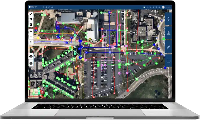
SiteMap® is a project & facility management software application that provides accurate existing condition documentation to protect your assets & people. The application lets you visualize your world as it’s being built with SiteMap®. You can quickly access, view, and share your infrastructure data securely with subcontractors, engineers, and your team.
All of your utility, structural, water & sewer, and facility information is uploaded into the SiteMap® Map Viewer and Digital Plan Room. You can document construction progress with our Progressive Capture (ProCap) service which utilizes 3D photogrammetry or 3D laser scanning to track the evolution of the site and document key project milestones. Virtual Tours like WalkThru 3D allow you to virtually walk-through a site or facility in minutes, take basic measurements, estimate clearances and distances, and add digital notes.
Key Features of SiteMap®:
High-Resolution Mapping: Through the use of advanced assessment techniques and imaging technologies, GPRS provides SiteMap® with accurate data, which then allows us to
generate layered, high-resolution maps of underground utilities, surpassing the limitations of traditional methods. This level of detail enables stakeholders to pinpoint the exact location of pipes, cables, and other infrastructure components with precision.
High Accuracy: One of the standout features of SiteMap® is its ties to GPRS, meaning that each client receives the same world-class service and technology as they do with GPRS. This includes GPRS’ 99.8% accuracy, earned across over 500,000 jobs nationwide. No other platform can claim this relationship or this level of verifiable accuracy.
Customizable Visualization: SiteMap® offers customizable visualization tools that allow users to overlay utility maps with additional contextual information. This multidimensional approach enhances decision-making processes and facilitates collaboration among project stakeholders.
Risk Assessment and Mitigation: SiteMap® enables users to better perform risk assessments and identify potential hazards associated with underground utilities, such as corrosion, leakage, or proximity to excavation sites. By proactively addressing these risks, stakeholders can minimize disruptions and ensure the safety of infrastructure projects.
Not SUE, But SiteMap®
![]()
When thinking of digital mapping, you may instantly think of SUE, subsurface utility engineering. While SiteMap® and GPRS don’t offer SUE, we do employ a lot of the same technologies and support QL-B SUE. SiteMap® is used to map private utilities, of which aren’t legally required to be reported to 811. Digging without locating and mapping private utilities means that many project managers have to guess, using outdated data to identify where public and private utilities meet. This is a dangerous game, and SiteMap® helps take the danger out of the subsurface.
Private Utility Locating
Private utility locating helps to identify underground utilities in private, municipal, and commercial properties. All utilities that are found will be visually marked with paint, letting all field personnel know that they need to avoid that area. Some of the utilities that are typically discovered and marked include:
- gas pipes
- backup generator lines
- sewer laterals
- septic tank pipes
- irrigation systems
- storm drains
- site lighting lines
- telecommunication lines
Private utility locating services are also useful in facilities like schools, hospitals, apartments, and military installations that are not considered publicly owned. Remember that these utilities are below the ground and may not be visible, so calling for private utility locating services is the best thing to do.
Subsurface Utility Engineering (SUE)
Subsurface utility engineering is comprehensive subsurface utility locating to find underground utilities like cable lines and gas lines. The results help project managers make informed decisions about whether to re-design the projects or relocate the utilities ahead of the beginning of the project.
SUE reduces project delays caused by waiting for utility owners to relocate utilities before the project can begin. Besides, project designers don’t have to start re-designing the project in case of a utility conflict.
Some of the activities involved in the SUE process include:
- Utility mapping
- Utility coordination and design
- Utility relocation and accommodation cost estimates
- Condition assessment
Together with site surveys, geophysical and civil engineering techniques, SUE services will provide quality information to the concerned parties.
Both SUE and SiteMap® can play an important role in keeping our world safe and moving forward. While we don’t offer SUE, we share similarities, especially in the common goal of mapping the world around us.
Utility Locating with GPRS
With over 500 Project Managers stationed in every major market across the United States, GPRS has an unmatched nationwide utility mapping & utility locating service network. States provide a public utility locating service (811) free to anyone excavating to prevent public utility strikes. The contractor on the project is required by law to call 811 to avoid subsurface damage.
811 services go by different names depending on what state in which you reside. Some common names for this service are Call Before You Dig, Dig Alert, Digline, and One Call.
The most important thing to note is that 811 services are limited to public utilities; they do not account for private utilities that may also run through your job site. Further, 811 marks the location of the line, but does not provide a depth measurement.
At the point where a line connects into the infrastructure of a private facility, it is no longer considered a public utility. This is where it is vital to employ a private utility locating service such as GPRS. We can determine line depth, the location of abandoned lines, and more, and we provide you with high-quality digital maps, markings and a complimentary PDF and .KMZ file to complement the services of 811 and give you a comprehensive picture of the built world on your site.
GPRS’ Project Managers primarily utilize ground penetrating radar (GPR) and electromagnetic (EM) locators to find buried utilities.
GPR is the most efficient and accurate tool for modern utility locating. This non-destructive detection and imaging method involves sending a radio signal into a structure and then reading the “bounce” of those radio waves off any material they encounter.
EM locating is a complementary technology to GPR. An electromagnetic signal is either sent through an underground utility line by a transmitter, or the receiver searches for an existing electromagnetic signal in an active line.
The data from these various technologies is compiled by your Project Manager to create an accurate map of the underground infrastructure on your property. When you use GPRS, you use a service that is changing the way we build and preserve the future.
SiteMap® represents a welcome change in the field of digital utility mapping, offering unparalleled insights into the complex world of underground infrastructure. From mapping water and sewer lines to electrical utilities, SiteMap® empowers stakeholders with the tools and knowledge needed to navigate the subterranean landscape safely and efficiently. As we continue to embrace technological innovation in urban development and infrastructure management, solutions like SiteMap® will play a pivotal role in shaping the cities of tomorrow\
See the subsurface with SiteMap®, contact us today.