As we stride forward in the 21st century, our reliance on buried infrastructure has never been more profound. From telecommunications to water and sewer systems, these underground networks pump life through our modern society. However, with the privilege of access comes the responsibility of maintenance and protection. The 2022 Damage Information Reporting Tool (DIRT) report sheds light on the challenges and initiatives in reducing utility strikes, offering valuable insights into improving infrastructure asset management. This report helps professionals throughout the nation identify key issues and form solutions to match. But what are the key findings and how does SiteMap® (patent pending), powered by GPRS, address these issues?
Understanding the Landscape
The 2022 DIRT report highlights consistent challenges and a concerning uptick in damages across various sectors. For the first time, excavation and construction activities topped the list of reporting sources, signaling a shift in the landscape. Telecommunications and natural gas facilities remain the most commonly damaged, with telecommunications work accounting for the highest number of damages, closely followed by water and sewer projects.
Analyzing The Data
A regression analysis spanning 2020-2022 reveals damages and the costs associated have increased for the third year in a row. Predictive metrics such as damages per unit of construction spending and per thousand 811 transmissions have seen notable increases, underscoring the urgency to reverse these trends. The proof of an ever-occurring problem is in the data:
- Damages per million dollars of construction spending and damages per one thousand 811 center transmissions increased 12.35% and 9.34% respectively from 2021 to 2022.
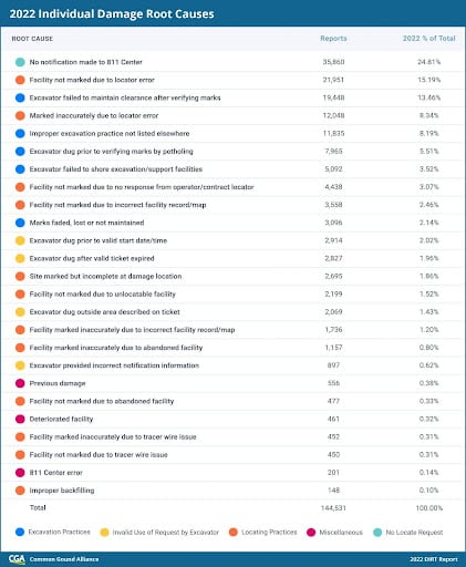
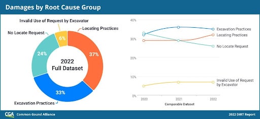
- In 2022, the top six root causes make up nearly 76% of damages, with each major root cause group represented. The top six root causes also ranked highest in 2021, indicating a consistent set of prevalent issues.
- The excavation practices root cause group made up 33% of damages with a known root cause in the 2022 full dataset. The majority (59%) of damages in this group point specifically to failure to maintain clearance and/or failure to pothole.
- Data from seven states shows that as many as 56% of tickets receive late or no positive response, meaning work cannot legally start.
- Telecommunications and water/sewer operators have higher late response rates.
To meet the industry challenge of reducing damages by 50% in five years, such as reported in Chicago, concerted efforts are required.
Chicago has cut underground utility damages in half since 2017 through its robust prevention program run by 811 Chicago. This service of the Chicago Department of Transportation (and located within the Division of Infrastructure Management) achieves damage reduction through:
- Project design reviews ensure new utilities avoid existing infrastructure. Facility maps aid planning.
- Permitting requires approved designs. Permit documents provide excavators with utility details.
- Enforcement of damage prevention laws via investigations and sanctions.
- Mapping tools like dot Maps showing project and ticket data. This enables coordination.
Chicago’s success highlights several adoptable practices:
- Sharing facility maps for planning purposes provides the data necessary to prevent damages without revealing sensitive details.
- Open communication on designs gives owners a voice and excavators foresight on potential conflicts.
- Collaboration from the start fosters stakeholder relationships and buy-in.
- Empowered excavators have the resources they need to identify buried infrastructure.
- Chicago demonstrates that the damage prevention process works best when all parties commit to transparent planning, cooperation and accountability from project outset through excavation.
Addressing Late Locates
The timeliness and accuracy of locating emerge as critical concerns, with excavators often unable to legally commence work as scheduled. Telecommunications and water/sewer operators contribute significantly to instances of delayed locates. With impending infrastructure projects on the horizon, rectifying these issues becomes paramount to prevent costly delays and accidents.
The Future of Damage Prevention
To enhance insights and accountability, initiatives such as monthly reporting and near-miss data submission are being introduced. These measures aim to provide timely analysis and foster collaboration among stakeholders. Additionally, the development of a national damage prevention index will offer a comprehensive assessment of damage rates over time, aiding in benchmarking and progress tracking.
Leveraging SiteMap® for Effective Infrastructure Management
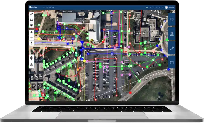
In this landscape of increasing challenges, SiteMap® emerges as a robust solution for infrastructure asset management. With its advanced GIS mapping software capabilities, SiteMap® offers utilities a complete view of their assets, facilitating proactive maintenance and risk mitigation. By integrating accurate data and an easy to use interface , SiteMap® empowers organizations to identify potential hazards and streamline operations.
This innovative infrastructure asset management software excels in providing a comprehensive and accurate digital twin of underground utilities. By leveraging its advanced GIS mapping software, SiteMap® enables utilities to utilize accurate, dynamic representations of their infrastructure, including pipelines, cables, and other vital components. Excavators and construction professionals can access these detailed virtual models, gaining insights into the precise locations and depths of utilities, thus mitigating the risk of accidental strikes during excavation projects.
Collaborative Efforts for Change
As we navigate the complexities of damage prevention, collaboration and shared accountability are paramount. By standardizing data collection processes, incentivizing comprehensive reporting, and targeting root causes, stakeholders can collectively drive meaningful change. Through commitments to innovation and best practices, we can safeguard our buried infrastructure for generations to come.
SiteMap® offers a single source of truth for project management and alike, enabling collaboration on all levels, and safeguarding the infrastructure both above and below ground. With SiteMap®, you get access to GPRS accurate data, often just within minutes of locate completion.
Better manage your job site or facility with SiteMap®. SiteMap® allows you to quickly access, view, and share your infrastructure data securely with subcontractors, engineers, and your team. All of your utility, structural, water & sewer, and facility information is uploaded into the SiteMap® Map Viewer and Digital Plan Room. You can document construction progress with our Progressive Capture (ProCap) service which utilizes 3D photogrammetry or 3D laser scanning to track the evolution of the site and document key project milestones. Virtual Tours like WalkThru 3D allow you to virtually walk-through a site or facility in minutes, take basic measurements, estimate clearances and distances, and add digital notes.
Identifying Root Causes: A Path to Solutions
Dominant Damage Drivers
Unpacking the root causes behind damages reveals that the top six contributors account for nearly 76% of all incidents. Failure to notify consistently tops the list, representing 77% of no-call damages. Interestingly, professional excavators are often responsible for these no-notification damages, with landscaping/fencing, water/sewer, and construction being the prevalent types of work associated.
The report identifies six primary drivers accounting for the majority of damages, offering a focal point for mitigation efforts. Failure to notify remains a persistent issue, particularly among professional excavators, with landscaping, fencing, and construction activities being common culprits. Additionally, failures in potholing and maintaining clearance pose significant risks, highlighting the need for improved processes and procedures.
Locating Challenges and Late Locates
A particularly alarming revelation is the crisis surrounding late locates. An analysis across seven states indicates that, as high as 56% of the time, an excavator faces legal restrictions on their planned start date. Telecommunications and water/sewer operations are the major contributors to these instances.
Proactive Strategies with SiteMap®: Best Infrastructure Asset Management Software
Monthly Reporting and Damage Indices
The future of damage prevention lies in monthly reporting and the submission of near-miss data through the Damage Information Reporting Tool. Initiatives like SiteMap® are crucial in providing unprecedented insights, enabling timely analysis, and fostering shared accountability across stakeholder groups.
To enhance future DIRT reports, the CGA is working on creating a U.S. damage prevention index. This index will offer a more accurate gauge of the rate of damages over time, aligning with the industry’s 50-in-5 challenge.
Collaboration, Reporting, and Analysis: Key Strategies
Commitment to Coordination
Coordination and flexibility within organizations and across stakeholder groups are pivotal for generating innovative solutions to systemic issues. Participating in the Damage Prevention Institute’s accreditation and peer review processes, coupled with monthly data submissions to DIRT, enhances the value of insights.
Standardized Data Collection
Standardizing data collection fields and processes across relevant stakeholder groups fosters greater portability of data for benchmarking. Incentivizing comprehensive damage and near-miss reporting across organizational departments, integrating reporting into operating workflows, and socializing tools to identify root causes contribute to a holistic approach.
Development of Damage Prevention Index
The development of a damage prevention index aims to measure fluctuations in the rate of damage to buried facilities over time, aligning with the industry’s ambitious 50-in-5 progress.
Targeted Initiatives for Reduction of Utility Strikes
Addressing No-Notification Root Cause
To combat the persistent issue of failure to notify, a targeted 811 outreach is crucial. This includes focusing on behavior change, particularly emphasizing consistent and effective use of the 811 system. Restoring confidence in the 811 system involves considering innovative ideas to meet locating demand while reducing unnecessary locate requests. Alternatively, using a platform like SiteMap® removes any issues with the 811 system. Remember, many private utilities are not reported, since they legally don’t have to be. SiteMap® identifies both public and private utilities, creating a comprehensive, unified view.
Tackling Excavation Root Causes
Prioritizing tolerance zone safety on the jobsite, investing in technology like vacuum excavators, and addressing contract structures are key strategies for reducing damages caused by failure to pothole/maintain clearance.
Facility owners/operators play a critical role in addressing these issues through stringent adherence to contract requirements and providing adequate compensation for potholing. Providing excavators with access to additional information, such as map visualizations through processes like Enhanced Positive Response, further enhances damage prevention efforts.
Mitigating Locator Error Root Causes
Allocating sufficient resources to meet marking timelines, enhancing facility maps to GIS-grade accuracy, and updating maps with field-captured facility location information are immediate steps to mitigate locator error root causes. Additionally, addressing contract structures and encouraging effective use of the 811 system through electronic white-lining and accurate ticket renewal practices contribute to overall reduction in locator workloads.
The 2022 DIRT report underscores the pressing need for proactive measures to address upward damage trends in utility strikes. By harnessing the capabilities of SiteMap® and embracing collaborative initiatives, utilities can enhance their infrastructure asset management practices and safeguard critical underground networks. As we forge ahead, let us remain steadfast in our commitment to protecting the lifelines of modern society. Together, we can build a safer and more resilient future.
Are you looking for a new way to see the subsurface? Contact us today.