The telecommunications industry has changed over the last 30 years, from several regulated natural monopolies to an industry that is economically capable of supporting multiple service providers in diverse markets. As a result, Congress, in the Telecommunications Act of 1996, opened the telecommunications market to as many entrants as possible in an effort to reduce the price of the communications systems and services to their lowest, most efficient level. This created a landscape of competitiveness and progress, boosted by the onslaught of the internet and other technologies, that has rapidly changed and evolved, continuing to do so today.
Because the landscape of telecommunications is rapidly changing, the necessity for robust infrastructure management cannot be overstated. Telecom companies worldwide face the ongoing challenge of safeguarding their extensive network of cables, fiber optics, and other essential components that lay beneath the earth’s surface. The need for innovative solutions to protect and manage telecom line infrastructure is more pressing than ever. SiteMap® (patent pending), powered by GPRS, offers a cutting-edge solution that leverages location intelligence, facility management software, and GIS technology to redefine the way telecom infrastructure is safeguarded and managed.

Telecommunications is the transmission of information over long distances using electronic signals, encompassing voice, data, and multimedia communication through technologies like telephony, data communications, broadcasting, and networking
The Role of Location Intelligence in Telecom Management
Location intelligence refers to the ability to utilize geospatial data and analytics to derive meaningful insights. In the context of telecom infrastructure, this translates into a powerful tool for precisely mapping the location of cables, fiber optics, and other assets. SiteMap® employs advanced GIS software to aid the creation of detailed, real-time existing subsurface conditions of the entire telecom network. This digital representation of GPRS’ 99.8%+ accurate field investigation and location results allows for accurate visualization of the network’s layout, enabling telecom companies to make informed decisions about asset maintenance, expansion, and overall infrastructure planning.
Facility Management Software for Telecom Excellence
Effective facility management is crucial for ensuring the longevity and optimal performance of telecom line infrastructure. SiteMap® excels in this aspect by serving as a comprehensive facility management software tailored specifically for the telecom industry. Through the platform’s intuitive interface, operators can track the condition of assets, monitor ongoing maintenance activities, and identify the need for proactive inspections. This proactive approach not only minimizes downtime but also extends the lifespan of telecom assets, ultimately contributing to improved operational efficiency and cost-effectiveness.
GIS Software: The Backbone of SiteMap® Technology
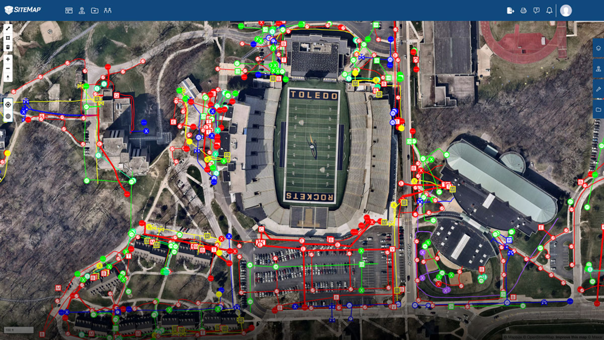
Real life example of how GIS helps SiteMap produce solutions that leverage location intelligence
Geographic Information System (GIS) software is at the heart of SiteMap®, providing the backbone for its robust functionality. With GIS, telecom companies gain the ability to spatially analyze and interpret data related to their infrastructure. SiteMap® utilizes GIS technology to create dynamic, multi-dimensional models that go beyond simple mapping. These models incorporate various layers of information, such as environmental factors, and demographic data, providing a holistic view of the telecom network. This comprehensive understanding enables telecom operators to anticipate challenges, optimize routes, and strategically plan network expansions with unparalleled precision.
Key Features of SiteMap® Technology for Telecom Safeguarding
1. Real-Time Digital Twins
SiteMap® data can aid in the creation of real-time existing conditions documentation and even complete digital twins of telecom line infrastructure, offering a dynamic, up-to-date representation of the network. This functionality is invaluable for telecom operators, allowing them to monitor changes, identify potential issues, and respond swiftly to emerging challenges.
2. Enhanced Asset Visibility
The platform enhances asset visibility by providing detailed information about the location, depth, and condition of telecom assets. This level of granularity empowers operators to implement targeted maintenance strategies, reducing the risk of unexpected failures and ensuring continuous service availability. All of the information you could need is just a few clicks away.
3. Proactive Maintenance Planning
SiteMap® facilitates proactive maintenance planning by accurately mapping and displaying the full picture. Telecom companies can schedule routine inspections, monitor asset health, and address potential issues before they escalate. This approach not only prevents service disruptions but also optimizes maintenance costs over the long term.
The Future of Telecom Infrastructure Management
As the telecom industry continues to evolve, the role of advanced technologies like SiteMap® becomes increasingly pivotal. The amalgamation of location intelligence, facility management software, and GIS technology not only safeguards telecom line infrastructure but also propels the industry towards unprecedented levels of efficiency and sustainability. With SiteMap® Technology at the forefront, telecom companies can navigate the complexities of modern connectivity with confidence, ensuring a seamless and reliable communication network for the future.
The landscape of telecom infrastructure is always changing, from the importance of data centers, to preserving older lines and routes, there’s a lot going on. SiteMap® helps break this tangled mass of lines down into digestible, understandable pieces. Simply click on an infrastructure asset in your map and you’ll be shown extra data (where applicable) fostering a complete understanding of your site, and where it’s heading.
The GPRS Difference
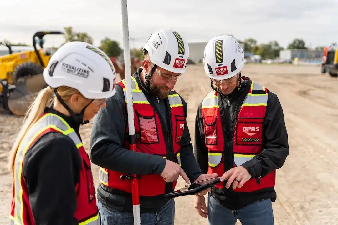
With over 500 Project Managers stationed in every major market across the United States, GPRS has an unmatched nationwide utility mapping & utility locating service network. It is quick and easy to find an expert Project Manager near you. GPRS ensures we can reach your location within 24 to 48 hours of contact to solve any and all of your utility locating & mapping needs.
Accurate, up to date as-built drawings and facility maps are a key to success for any construction project. The planning phase of a project relies heavily on the accuracy of the information obtained in the existing facility maps, which details the site’s underground infrastructure. With our facility mapping and modeling services, the GPRS Mapping & Modeling Team can update existing or create new as-built drawings that portray actual site conditions – including any variations, renovations, or unknown pipes.
The Mapping & Modeling Team can also export your GPR utility locates & concrete scans, 3D laser & photogrammetry data, and video pipe inspection reports to create accurate existing condition as-builts – above and below ground – to give you the accurate information you need in a format you can easily work with and share to keep your project on time, on budget, and safe.
SiteMap® is powered by GPRS, meaning you get the same level of quality and accuracy. In the realm of telecommunications, this is crucial, especially as our thirst for an electric existence continues to saturate the market, creating a demand for larger, better, faster, and well-maintained telecommunications infrastructure. SiteMap® is here to help safeguard that infrastructure, keeping the lights on and Netflix playing.
Are you looking for a simple subsurface data solution? Contact SiteMap® today.