In today’s rapidly evolving and expanding world, the need for efficient and reliable infrastructure (and its data) has become more crucial than ever. This is especially true in the United States, where the infrastructure is deteriorating so badly that it’s considered a national security threat. To help rebuild this infrastructure, many things are required, and one of those is accurate subsurface data representation and collection. From urban development to utility management, accurate information about underground assets is essential for planning, construction, and maintenance. Traditional utility locating methods have left us crumbling, with utility strike incidents on a three-year rise, With the advent of advanced technologies from GPRS and SiteMap® (patent pending), a new era of infrastructure intelligence is dawning, one that goes beyond utility locating and has the potential to revolutionize the future of infrastructure.
Clear documentation enhances public awareness of underground utility locations, promoting safety and minimizing disruptions during construction or excavation projects.
Understanding SiteMap®
SiteMap® is a cutting-edge technology that goes far beyond traditional utility locating methods. It combines advanced data collection techniques with 99.8% accuracy, a user-friendly interface, and advanced GIS solutions to provide a comprehensive and accurate representation of infrastructure assets, above and below ground.. By utilizing a combination of ground penetrating radar, electromagnetic induction, video[CCTV] pipe inspection, 3D laser scanning, and other non-destructive testing methods, SiteMap®, powered by GPRS, can create a detailed map of your subsurface and aboveground infrastructure.
SiteMap® offers many different benefits that can help you manage your project better than ever. Some of these features include:
- Secure cloud-based storage
- Upload and store as-built drawings and site records
- Ability to import existing infrastructure data
- Attach videos, photos, GPR data, and other documents
- Access to GPRS data (with a 99.8% accuracy rate)
- Search and share your data with your team easily
- View historical data (dependent on subscription)
- Interact with your aggregated data in the Map Viewer
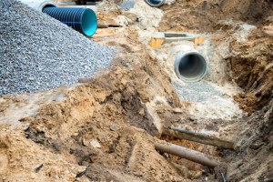
SiteMap® is full of features that help teams of all types complete their projects with ease and accuracy. The world we live in is becoming more congested, and with underground residential lines often buried within only 18-24 inches underground. This means that you’re closer to utility lines at all times than you’d think. Imagine what happens when one or even two of those lines are hit. A simple mistake could lead to thousands of dollars in damages, and worse, lives lost.
SiteMap® takes subsurface data and makes it easy to view, easy to interact with, and easy to learn from. This is crucial in a world that is constantly changing, growing, and developing over millions of subsurface utility lines, many of which are mis-mapped, or misrepresented.
The Power of Infrastructure Intelligence
SiteMap® offers a range of benefits and features that can be customized to meet your needs. With its ability to represent vast amounts of data, it provides valuable insights into the location, condition, lifespan, and performance of assets. This information enables infrastructure managers and other professionals to make informed decisions regarding maintenance, upgrades, and future planning. By leveraging infrastructure intelligence, organizations can optimize resource allocation, reduce costs, and enhance overall operational efficiency.
SiteMap® harnesses the power of information and visualization, combining them to create one powerhouse of a GIS mapping software that not only provides accurate data but allows users to control their data and better inform their processes. When infrastructure intelligence is utilized correctly it can:
- Reduce utility strikes
- Foster innovation and progression
- Secure the subsurface
- Foster education and understanding of subsurface changes/planning
- Help inform planning and maintenance
- Save money and time
- Help track changes
- Help create a record of our nation’s infrastructure
And more
GPRS has maintained a 99.8% accuracy rate on over 500,000 utility locating and concrete scanning jobs throughout the U.S. We require every GPRS Project Manager to be trained in and utilize Subsurface Investigation Methodology (SIM), an industry-leading program that ensures every GPRS field team member performs at an elite, expert level. Whenever possible, we include line depths in our locates, and can help you visualize your data in several ways, depending on your needs.
The applications are endless when it comes to SiteMap®, GPRS, and advanced infrastructure intelligence. This data can be used however it’s most useful to you and your team, making it an excellent tool for nearly any industry.
Enhancing Safety and Risk Mitigation
Perhaps one of the most significant advantages of SiteMap® is its potential to enhance safety and mitigate risks associated with underground infrastructure. According to Common Ground Alliance (CGA)—there are between 400,000 and 500,000 utility strikes reported in the U.S. each year. By accurately mapping the location of utilities, teams of all types can avoid accidental damage during their work, reducing the risk of service disruptions, injuries, and costly repairs. Even digging a new garden comes with a risk of hitting a utility line. Further, SiteMap® can identify potential conflicts between existing utilities and proposed construction projects, allowing for proactive planning and risk mitigation for many industries.
While it’s required by law to call 811 before you dig, nearly 25 percent of the reported utility strikes follow a failure to notify 811. Beyond that, even if 811 is called, the information given may not be accurate, as many of our nation’s utilities are mismarked, improperly mapped, or completely lost. Utility strikes cost more than $100 billion in damages globally yearly. GPRS is on a mission to map 100% of the nation’s utilities, creating a safer, more progressive country with far better infrastructure. SiteMap® helps take the accurate data provided by GPRS and makes it readable, understandable, interactive, and shareable. With SiteMap®, you need no extra training to understand the data at hand, opening important infrastructure data to anyone who needs it, regardless of experience.
The Future of Subsurface Intelligence
SiteMap® is at the forefront of subsurface mapping & facility visualization services, and we understand just how important it is. As the population grows, the need for living spaces and utilities to power them will continue to grow. As it currently stands, our infrastructure system cannot support an increased need, nor is it properly mapped to support extra digging or construction efforts.
SiteMap® and GPRS have the technology to help tie together subsurface data with action, helping everything from exploring undiscovered carbons to urban planning efforts. Many sources state that going digital will be what subsurface infrastructure intelligence needs to advance, and SiteMap® is already there, powering a shift from physical data to digital while doing so accurately and simply.
As things evolve, SiteMap® will likely improve connection to the Internet of IoT) and other smart systems and concepts, furthering connectivity and understanding, and bridging the gap between the underground and the aboveground. The better we can bridge communications, making subsurface data accessible and easy to understand, the better our communities can use this data for their planning and progression. With the use of AI, systems will likely continue to become more intuitive, smarter, accessible, and interactive, allowing a heightened level of education and connection between the two worlds. Seeing the subsurface is easy with SiteMap®, and as the technology evolves, SiteMap® will too.
SiteMap® represents a significant leap forward in infrastructure intelligence, going beyond traditional utility locating methods to provide a comprehensive understanding of underground assets and underground utility mapping practices. By harnessing the power of advanced data representation techniques and advanced mapping practices powered by GPRS, SiteMap® enables organizations to make informed decisions, enhance safety, and optimize resource allocation. As we embrace the future of infrastructure management, SiteMap® will play a pivotal role in shaping a more efficient, resilient, and sustainable built environment. SiteMap® helps make the subsurface simply accessible.
Learn more about how SiteMap® can help your project today, contact us.