The year is 1979, and you just heard something big explode somewhere outside. You rush to your door, searching for its source. The sound was so startling and heavy that it rattled your walls, your sunburst clock fell to the avocado shag rug below it. When you open the door and step out into the sun, smoke, and haze cast a sheet over it, like a fine nylon mask. Just down the road, your neighbor was trying to dig a new garden, and while they certainly have a hole in the ground, you’re fortunate to be there. Your neighbor hit a utility line, and without a way to know what’s under the surface, it’ll happen again.
The year is 1982, and the word SUE is starting to become more than just a woman’s name in some circles. In 1985, the first statewide SUE contract with the Virginia Department of Transportation was created. By 1991, FHWA began promoting Subsurface Utility Engineering (SUE), but it would take until 2018 for over 38 State DOTs to start using Statewide\DistrictWide\Region-Wide UES Services. While GPRS and SiteMap® (patent pending) don’t offer SUE, they do use the same technology types that support SUE. It also wouldn’t be until 2005 for 811 to be created, which meant a lot of neighbors blowing up their gardens. Unfortunately, many people still do, even with 811 nearing its 20th year, as a good portion of people fail to utilize 811 before digging, despite it being the law in most places.
Subsurface utility information and mapping have evolved and have advanced throughout the last forty years. GPRS is at the forefront of this evolution, offering an amazing 99.8% accuracy rating for engineers, project managers, and other professionals alike. SiteMap® complements GPRS in a way that no other utility mapping service could, but how? How does SiteMap® stand out?
Visualizing The Unseen
Subsurface utility management is crucial to the success of urban development and upkeep, even when the urban area is more rural. Being able to see utilities below the surface is crucial to the livelihood of utility systems and other important processes of society.
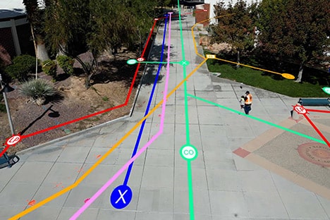
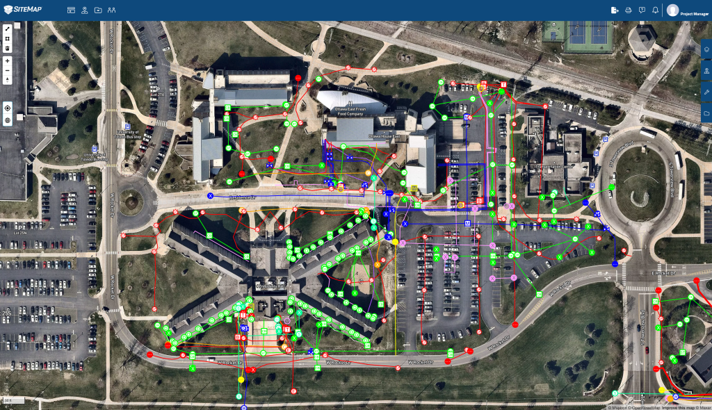
SiteMap® works as a unique solution for utility data visualization, interpretation, and interaction. Backed by the high accuracy of GPRS, SiteMap® offers what no other source can.
When you hire GPRS to locate your outdoor utilities, you’re provided with a free PDF and .KMZ file of your utility map. Our Video Pipe Inspection [CCTV] service provides NASSCO-certified photo and video reporting including every pipe defect and its severity.
Our Mapping & Modeling team can utilize your data and information to create anything from a simple GPS-enabled map of your utility locate to, in conjunction with 3D laser scanning, complete CAD drawings, or a full 3D point cloud or BIM model of your facility, depending on your needs. Your data is also completely aggregated, tagged, and locatable in your SiteMap® account. Depending on your subscription level, you could keep every part of your record drawings, as built data, and specifications in this one single source of truth, secured and shareable with your team from anywhere, 24/7. GPRS turns your built world into easily accessible and accurate data with SiteMap®
Simply Map with SiteMap®
When you hire GPRS to intelligently visualize your project or facility, you receive a complimentary SiteMap® Personal subscription that allows you to see, secure, and share the data you need with the people who need it. Depending on your needs and wants, you may opt for a different level of SiteMap® subscription, which may open more features and ways to interact with your data. All of your utility data is uploaded within minutes of your GPRS job completion. Your structural, water & sewer, and facility information is uploaded as soon as its complete. This data is then geolocated, layered, and secured for your immediate use to eliminate miscommunication, and inaccurate, out-of-date information. With SiteMap®, utility mapping is easier than ever before. Subsurface utility management is made easier when you’re able to see the world below you.
The use of subsurface mapping software isn’t just smart, it saves money too. The use of SUE services has become a routine requirement on highway and bridge design projects and is strongly advocated by the Federal Highway Administration (FHWA) and state departments of transportation. A savings of $4.62 for every $1.00 spent on SUE was quantified by the FHWA from a total of 71 projects.
With SiteMap®, you can quickly access all your as-builts and location data via our industry-leading facility infrastructure data platform. SiteMap® stores, layers, and geolocates everything from drone photogrammetry to 3D BIM walkthroughs to conceptual site models, abandoned pipes, and USTs.
SiteMap® is here to help make seeing the subsurface simple.
Manage Risks Properly
Throughout the years, solving the issue of utility strikes has been a recurring task. GPRS has taken this gigantic task and has made huge bounds to Intelligently Visualize The Built World, so you can see your subsurface data, and mitigate risk. GPRS is committed to helping you manage and mitigate risk on your job and for your team. GPRS provides complete facility infrastructure visualization through utility locating, concrete scanning & imaging, 3D laser scanning, video pipe inspection, leak detection, drone photogrammetry, and state-of-the-art mapping & modeling services so that you and your team can see potential hazards and design obstacles and mitigate risk to keep your project on time, on budget, and most importantly, safe.
GPRS’ goal and SiteMap®’s too, is 100% subsurface damage prevention, and we’re getting closer, having achieved and maintained a 99.8% accuracy rate in concrete scanning & imaging and underground utility locating on more than 500,000 jobs and counting.
When you call GPRS, we use the latest in locating and scanning technology to make sure that we help keep your people, and ours, safe. When GPRS places a green box within a layout before cutting or coring concrete, they guarantee that the area is free of obstructions.
Throughout The Years
In April 1995, the Board of Direction approved the revision to the American Society of Civil Engineers (ASCE) Rules for Standards Committees to govern the writing and maintenance of standards developed by ASCE. Since its implementation, there have been many, including:
- ASCE 15-98 Standard Practice for Direct Design of Buried Precast Concrete Pipe Using Standard Installations (SIDD)
- ASCE 20-96 Standard Guidelines for the Design and Installation of Pile Foundations
- EWRI/ASCE 33-01 Comprehensive Transboundary International Water Quality Management Agreement
- CI/ASCE 38-02 Standard Guideline for the Collection and Depiction of Existing Subsurface Utility Data
To meet the requirements and changes throughout the years, GPRS and SiteMap® have elevated their services to new lengths. With over 500 Project Managers stationed in every major market across the United States, GPRS has an unmatched nationwide utility mapping & utility locating service network. It is quick and easy to find an expert Project Manager near you. GPRS ensures that someone can reach your location within 24 to 48 hours of contact to solve any of your utility locating & mapping needs.
There are plenty of subsurface utilities to keep track of, with the U.S. claiming over 800,000 miles of public sewers and 500,000 miles of private lateral sewers connecting private property to public sewer lines. Each of these conveyance systems is susceptible to structural failure, blockages, and overflows.
With updated requirements, and updated utilities, comes the need for updated technologies, which is where GPRS and SiteMap® excel. GPRS offers state-of-the-art technology, with over 500,000 successful jobs under their belt, while SiteMap® takes this data and turns it into easy-to-share, easy-to-access, and easy-to-understand maps and visualizations. The data in SiteMap® is easy to understand by anyone, no matter if they have previous experience. SiteMap® has helped streamline communications, making sites safer and simpler. 50% of site damages are due to lack of communication. It’s not 1979, and you don’t have to communicate like it is either, especially not when SiteMap® can help.
The science of subsurface utility infrastructure and its management has evolved greatly throughout the years. While there’s still a lot of work to do, GPRS and SiteMap® are on the front lines, mapping things and making the subsurface available to communities and teams like yours. In a world of great technology, there’s no excuse for utility strikes to be on the rise. Technology like what GPRS and SiteMap® use daily is what the 2022 DIRT report recommends everyone use to accurately locate and map utilities for their 50-in-5 initiative, which is slated to help reduce incidents by 50% over the next five years. The 70s were great, but utility strikes aren’t. Before you dig, contact SiteMap® for out-of-this-world technology and subsurface mapping practices, ya dig?
You better not, not unless you’re looking at SiteMap®.