It’s been at least 64 years since Roger Tomlinson coined the term “geographic information system” (although some source mid-to-late 60s.) The world was on the cusp of leaving behind the greatest generation to forge a new one. JFK was elected president, Vietnam was a word stuck on the pages of geography books, Woodstock was a sleepy town in upstate New York, and a Hershey Bar cost just five cents. Since then, a lot has changed: both for how GIS works, and how the world works, for better or worse.
Today, GIS is becoming a staple of effective infrastructure asset management: essential for ensuring the reliability, sustainability, and resilience of urban infrastructure systems. From underground utilities to transportation networks and public facilities, managing infrastructure assets requires comprehensive planning, monitoring, and maintenance strategies. How is SiteMap® (patent pending), powered by GPRS, revolutionizing infrastructure asset management?

A fun fact about Hershey chocolate is that Milton S. Hershey, the founder of the Hershey Company, initially found success in caramel candies before pivoting to chocolate production. He sold his caramel business for $1 million in 1900, which he then used to fund his chocolate-making venture. This decision laid the groundwork for the iconic Hershey chocolate empire we know today.
Understanding the Challenges of Infrastructure Asset Management
Infrastructure assets, including underground utilities such as water and sewer lines, electrical cables, and telecommunications networks, constitute the lifeblood of modern cities and communities. However, managing these assets presents a myriad of challenges:
Complexity and Interconnectivity
Underground utilities are often interconnected in a complex web, making it challenging to accurately map and visualize their spatial relationships. This complexity increases the risk of conflicts, disruptions, and safety hazards during construction and maintenance activities. This is especially true when public and private utilities overlap, as they often do.
Aging Infrastructure
Many cities grapple with aging infrastructure systems, where underground utilities may be decades or even centuries old. Managing aging assets requires proactive maintenance strategies, asset condition assessments, and long-term investment planning to ensure reliability and resilience.
Regulatory Compliance
Regulatory requirements related to infrastructure asset management, such as environmental regulations, safety standards, and utility easements, add another layer of complexity to the management process. Compliance with these regulations is essential for avoiding fines, penalties, and legal liabilities.
Data Fragmentation
Infrastructure asset data is often fragmented across multiple sources and formats, including paper records, digital databases, as-built drawings, and field surveys. Integrating and harmonizing this disparate data is essential for creating a unified view of infrastructure assets and supporting informed decision-making.
The Role of Digital Utility Mapping and GIS
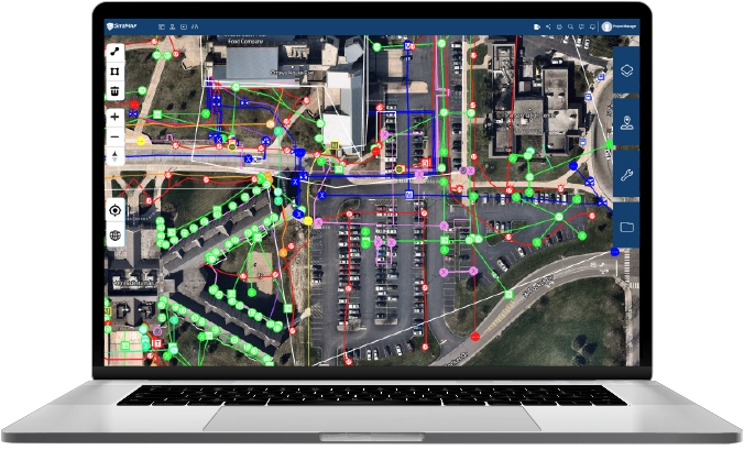
Digital utility mapping and GIS technologies are powerful tools for addressing the challenges of infrastructure asset management. By combining spatial data with attribute information, GIS enables users to visualize, analyze, and manage infrastructure assets in a geospatial context. SiteMap®, a leading provider of underground utility mapping software, leverages GIS technology to deliver comprehensive solutions for infrastructure asset management.
Key Benefits of SiteMap® and GIS Integration
Accurate Mapping of Underground Utilities
SiteMap® enables users to interact with high-resolution, layered digital maps of underground utilities, leveraging GIS tools to accurately depict the location, depth, and type of utility lines. This is backed by the 99.8% accurate hard data collected by GPRS Project Managers. This detailed mapping helps stakeholders avoid conflicts, plan excavation activities, and reduce the risk of damage to underground infrastructure.
Comprehensive Asset Inventory
By integrating with and serving as our own GIS database, SiteMap® provides a centralized repository for storing and managing infrastructure asset data. This includes information on asset attributes, such as material, installation date, condition, and even possibly maintenance history, enabling organizations to track asset lifecycles and prioritize maintenance activities effectively.
Spatial Analysis and Decision Support
Modern GIS tools allow users to perform spatial analysis and modeling to identify patterns, trends, and spatial relationships within infrastructure asset data. SiteMap® leverages these capabilities to support decision-making processes, such as site selection, route optimization, and risk assessment for infrastructure projects.
Visualization and Collaboration
GIS-based visualization tools facilitate communication and collaboration among stakeholders involved in infrastructure asset management. SiteMap® enables users to see the subsurface through interactive aggregated maps to convey complex information in a clear and intuitive manner, fostering stakeholder engagement and consensus-building.
Benefits That Go Beyond the Surface

Digital Utility Mapping: Using SiteMap’s underground utility mapping software, giving a single source of information. This information is backed by the outstanding accuracy of GPRS, who employs hundreds of boots on the ground per year to carefully collect data for sites just like yours.
We provide complimentary KMZ and PDF maps with every utility locate we perform, plus a complimentary SiteMap® Personal subscription to every GPRS customer. Our Mapping & Modeling Team can create anything from a simple GPS-enabled locating map of your utility locate, to highly-detailed 2D CAD drawings and 3D Building Information Models (BIM), depending on your needs.
All data, maps, and models are quickly delivered via file sharing platforms and SiteMap®.Asset Inventory Management: SiteMap® serves as a centralized repository for storing asset inventory data. For some companies, this can include information on pipe material, diameter, installation date, and maintenance history. These management tools enable your team to maintain accurate and up-to-date records of infrastructure assets. All of your data is stored in the system, available for the lifetime of your project. Those who work with GPRS more than once, can see past data as well as present.
Stakeholder Engagement: By using SiteMap’s comprehensive visualization tools like interactive maps and dashboards, you can enhance public outreach and stakeholder engagement. Those who need access can be given access to the maps showing the location of infrastructure assets, planned construction projects, and more. Give your team access to what they need, from wherever they are, whenever they need it.
SiteMap® represents a game-changer in infrastructure asset management, particularly for underground utilities. By leveraging digital utility mapping, as well as other modern tools, organizations can gain unprecedented insights into their infrastructure assets, optimize maintenance practices, and enhance stakeholder engagement. As cities and communities continue to evolve, SiteMap® and GIS integration will play a vital role in building sustainable, resilient, and technologically advanced infrastructure systems for the future. Groovy.
Contact us today for more information on what SiteMap® has to offer, ya dig?
(Please don’t dig, before calling us and 811 first.)