Managing utilities has always been a task for society to solve. Consider how we light the world, for instance. Early societies used natural gas which was led through bamboo pipes from volcano gas leaks to the streets of Peking. This gas served as a fuel for street lamps. As early as 500 B.C. Ancient Romans used oil lamps filled with vegetable oil in front of their houses. The need to organize lighting evolved, and in 1417, Sir Henry Barton ordained the law that houses must hang lanterns outside at nightfall. In 1524, Paris streets were illuminated by order, arranging that all houses had light in the windows. From there came “link-boys”, servants of wealthy children of London who were paid to carry torches while accompanying them. This early need for lighting then evolved to gas streetlights, which were lit by lamplighters, and glowed throughout the night of our early societies.
And all of that history is just in service of streetlights. If just one use case for one type of municipal infrastructure requires all that innovation and evolution, it’s no wonder that most communities and facilities have a massive web of underground utilities and no accurate map to untangle them all.
Today’s urban landscapes create a need for efficient infrastructure management. However, managing underground utilities presents unique challenges due to their concealed nature and intricate networks. SiteMap® (patent pending), powered by GPRS, is revolutionizing underground utility mapping and management, changing the way you see the subsurface.
The Importance of Underground Utility Mapping
Understanding the significance of underground utility mapping is crucial for grasping the impact of solutions like SiteMap®. Here are just a few key reasons why underground utility mapping is vital:
Cost Savings
According to the American Public Works Association (APWA), damage to underground utilities during excavation activities costs the U.S. economy an estimated $30 billion annually. Other estimates put that number at closer to $60 billion. Accurate mapping can help minimize these costs by avoiding utility strikes and associated repair expenses.
Safety Enhancement
According to the Common Ground Alliance (CGA) and the Occupational Safety & Health Administration (OSHA), utility strikes are a leading cause of workplace fatalities in the construction industry. Specifically, electrocution is cited as part of OSHA’s Fatal 4 risks on a job site. Accurate underground utility mapping can significantly reduce the risk of accidents and injuries, enhancing workplace safety.
Environmental Protection
Damage to underground utilities can lead to environmental contamination, water pollution, and habitat destruction. By preventing utility strikes, accurate mapping contributes to environmental preservation and sustainability efforts.
Urban Advancement
Properly monitoring your infrastructure is important when it comes to advancing our cities, towns, and populations. Our utility grid has to be one that can properly maintain our current population, as well as support growth, change, and new technologies. For instance, efficient telecommunication services rely on network mapping. This aids in the planning and deployment of communication services. Other systems include (but are not limited to):
- Sewer Systems: The underground mapping of sewer systems allows people to enjoy the proper functioning of sewage networks.
- Stormwater Drainage: Proper underground utility mapping helps manage water run-off during heavy rainfall. This process reduces the risk of flooding, property damage, and even fatality.
- Fiber Optic Cables: Due to the increasing reliance on high-speed internet and data transmission, accurate mapping of fiber optic cables is vital for efficient network management and expansion. This also helps prevent networks from doing down or experiencing damage during inclement weather.
How we manage our utilities dictates our speed of municipal progression. The better we understand the subsurface, the better adapted we’ll be to build an outstanding future of well-connected cities and towns.
The Role of SiteMap® in Underground Utility Mapping
SiteMap® plays a pivotal role in transforming underground utility mapping with its advanced technology and comprehensive features. Here’s how SiteMap® helps unlock the benefits of underground utility mapping:
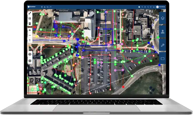
High-Precision Mapping: SiteMap® offers high-precision mapping capabilities, allowing users to accurately visualize the location, depth, and type of underground utilities. This precision minimizes the risk of utility strikes and ensures the safety and integrity of infrastructure assets.
High Accuracy: With SiteMap®, users gain access to GPRS 99.8% accurate locate data. Once you order a locating service with GPRS, you’re given free access to a SiteMap® Personal account, which you can upgrade and customize to meet your needs. In your Personal SiteMap® account, you’ll be able to interact with your subsurface data like you never have before. Because GPRS carefully collects this data using some of the most advanced technologies, the data provided is some of the most, if not the most accurate on the market.
Comprehensive Reporting: SiteMap® generates comprehensive, layered visualizations, providing stakeholders with actionable insights into underground utility assets. This reporting supports informed decision-making, regulatory compliance, and stakeholder communication. The Digital Plan Room acts as your data control center. It’s like a vault containing every file and map on any GPRS locating job.
Share Easily: The Map Viewer allows you to eliminate confusing communications by stripping away all the layers your contractors don’t need to show them exactly what they need to see, when they need to see it. Put everyone on the same page with a single source of truth that is accessible to everyone who needs it for the life of your project, 24/7 from any computer or mobile device.
Unlocking the Benefits of SiteMap®
SiteMap® represents a needed shift in underground utility mapping, offering unparalleled precision, ease of use, and mobility. By leveraging SiteMap®, organizations can unlock a host of benefits, including cost savings, safety enhancement, and environmental protection. As cities and communities continue to grow and evolve, the importance of accurate underground utility mapping will only increase, making solutions like SiteMap® indispensable for navigating the subsurface and ensuring the reliability and sustainability of infrastructure networks. Gone are the days of lamplighters, but natural gas resources remain, and they need to be monitored properly. SiteMap® helps unlock the subsurface, making monitoring utilities and other assets and features easier than ever before.
Are you ready to interact with the subsurface on a new level? Contact SiteMap® today.