Imagine being told to draw an apple with great detail. Your visualization has to reflect exactly what the apple looks like, or your entire neighborhood may blow up. Suddenly, every pencil stroke you take is an additional risk to your community.
While it may seem silly, the scenario described above is a perfect metaphor for the risks inherent in construction and excavation on jobsites and at facilities across the country.
So, if someone offered you an exact 3D replica of the apple – accurate within millimeters and designed to avert disaster for your neighbors and reduce or eliminate costly accidents and mistakes – you would likely find that valuable, right?
Welcome to the World of the Digital Twin
Digital twins are excellent tools for understanding the physical in a virtual realm. In an era where sustainable construction practices and digital innovations are reshaping the landscape of infrastructure development, the concept of digital twins has emerged as a powerful tool for optimizing construction processes, streamlining virtual design and planning, and enhancing environmental stewardship.
At SiteMap® (patent pending), powered by GPRS, we are at the forefront of this revolution, leveraging cutting-edge technology to create digital twins that not only streamline construction workflows, but also promote sustainability and safety. How is SiteMap® leading the way towards smarter, greener infrastructure development?

Understanding Digital Twins in Construction
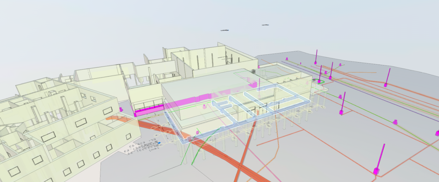
Digital twins are virtual replicas of physical assets, processes, or systems that mirror their real-world counterparts in real-time. In the context of construction, digital twins enable stakeholders, visual design consultants (VDCs), and other AEC professionals to visualize and simulate every aspect of a project, from design and planning to construction and operation.
By integrating data from various sources, including Building Information Modeling (BIM), Internet of Things (IoT) sensors, and geographic information systems (GIS), digital twins provide a comprehensive and dynamic representation of construction sites, allowing for better decision-making and resource optimization. With SiteMap®, digital twins are made possible thanks to the highly accurate data provided by GPRS, and a talented team of designers, data analysts, CAD technicians, and artists.
The Evolving Landscape of Smart Construction: A Digital Twin Perspective
In the realm of construction and architecture, the integration of digital twins is paving the way for a revolutionary shift in how buildings are designed, constructed, and managed. SiteMap®, with its advanced capabilities, acts as the mother of innovation in this landscape, offering a comprehensive platform that harnesses the power of digital twins for smart infrastructure development. The synergy between digital twins and SiteMap® holds immense potential to reshape the industry’s approach to sustainability, efficiency, and decision-making.
The utilization of digital twins in construction, a concept rooted in the NASA space program of the 1960s, has evolved into a common practice across various fields. SiteMap® takes this concept a step further by seamlessly integrating dynamic data sources, easy to understand visuals, and accurate information into its platform. The result is not just a static 3D model but a dynamic, data-driven representation of the job site. With 99.8% accurate data provided by GPRS, the visuals that SiteMap® produces are more than just a digital twin, they are a comprehensive guide to the world below and above.
This transformative approach contributes to enhanced efficiency, reduced costs, and the realization of sustainability goals. Digital twins, when embraced through SiteMap®, become dynamic decision-making tools that align seamlessly with the goals of smart construction.
The platform not only enhances the visualization, communication, and diagnostics aspects of digital twins, it also facilitates informed decision-making in an ever-changing landscape. The advanced capabilities of SiteMap®-powered digital twins make them indispensable tools for architects, construction professionals, and project managers aiming to achieve sustainability goals while optimizing resource utilization. While challenges such as standardization and data consistency persist with other platforms, SiteMap® is poised to play a pivotal role in accelerating the adoption of digitization tools in the industry, paving the way for a more sustainable and insightful approach to construction and infrastructure development.
The Role of Digital Twins in Sustainable Construction
Digital twins play a crucial role in advancing sustainability in construction by facilitating proactive planning, resource optimization, and performance monitoring. Through advanced simulations and analysis, stakeholders can identify opportunities to minimize waste, reduce energy consumption, and mitigate environmental impacts throughout the project lifecycle. Digital twins enable better collaboration between architects, engineers, contractors, and developers, fostering a holistic approach to sustainability that considers factors such as material selection, energy efficiency, and life cycle assessments.
SiteMap®: A Catalyst for Smart and Sustainable Construction
At SiteMap®, we recognize the importance of integrating digital twins into construction processes to drive sustainability and efficiency. Our SiteMap® platform offers a comprehensive suite of tools and features designed to empower stakeholders to create, visualize, and analyze digital twins with ease. From 3D modeling and intelligent visualization to annotated and aggregated data accurate within millimeters, SiteMap® provides a robust framework for optimizing construction projects and maximizing environmental performance.
Key Features of SiteMap® for Sustainable Construction
3D models are crucial as they facilitate better visualization, comprehension, and implementation across various fields
3D Modeling and Visualization
SiteMap® enables users to interact with their world via high-fidelity 3D models of construction sites, buildings, and infrastructure assets, above and below ground. From the dental industry, to the construction industry and beyond, 3D models are proving to be highly effective at conveying important data in greater detail. These digital representations provide a detailed overview of the project, allowing stakeholders to explore different design options, identify potential challenges, and visualize the impact of sustainable design strategies. SiteMap® makes visualizing your data easy, with easy to use visualizations and maps that allow for layer by layer view and information access.
Easily Shared
SiteMap® understands the challenges of those in the field and working via remote interfaces, and has created a platform that is easily accessed and used, no matter where you are or your education level. Project managers and stakeholders can quickly access their SiteMap® from anywhere, allowing your data and maps to be viewed by who needs them most, and only who needs them. SiteMap® makes infrastructure data easy to understand by using the Digital Map Room, which visualizes your GPRS collected data in easy to understand aggregated and annotated maps. This means that even those with little to no training can easily understand your SiteMap® data.
Safety and Sustainability
SiteMap® fosters safety and sustainability by making highly accurate data easily accessible and shareable, breaking down communication barriers and misunderstandings. According to a new report by global tech market advisory firm ABI Research, cities are expected to achieve cost savings of $280 billion by 2030 by using digital twins for more efficient urban planning. With SiteMap®, your entire team can be kept on the same page, fostering greater collaboration and understanding, while improving security and workflow. Further, SiteMap® is secure, meaning only those who are meant to see your SiteMap® will have access to your data. This allows you to safeguard your project site, while still getting the information you need.
Hypothetical Case Study: SiteMap® in Action for Sustainable Construction
To illustrate the transformative potential of SiteMap® in sustainable construction, let us consider a hypothetical case study of a large-scale infrastructure project. Using SiteMap®, stakeholders can have GPRS create a digital twin of the construction site, incorporating data on building materials, energy systems, and environmental conditions. Through the power of accurate data, SiteMap® can help project managers to identify opportunities to optimize energy efficiency, reduce waste, and enhance the resilience of the infrastructure.
Digital twins are revolutionizing the construction industry by providing a powerful platform for sustainable development and innovation. North America is expected to hold the highest share of the digital twin market moving forward. At SiteMap®, we are committed to leveraging this technology to drive smart, green infrastructure projects that enhance the quality of life for communities while preserving the environment for future generations. By harnessing the capabilities of SiteMap®, stakeholders can unlock new opportunities for collaboration, efficiency, and sustainability, paving the way towards a brighter and more resilient future.
Don’t struggle to visualize an apple when there’s an apple tree right in front of you. Contact SiteMap® today to learn more about digital twins and how we can help you see the subsurface.