Cartography, once the art of manhandling hulking maps, has been brought into the digital age. Within the construction industry, this transformation is both radical and vital. Here we delve into the linchpin technology of SiteMap® (patent pending) and its metamorphic interplay with electronic white lining. Unexpectedly subtle in its potency, SiteMap® is the vanguard of the digital cartography that’s changing the way we lay the groundwork for facility management, construction, and municipal projects. For construction managers, site engineers, and urban planners, the following exploration is your A-Z guide to not just embracing the change but leveraging it for the betterment of your projects.
The Essence of SiteMap® Pro
SiteMap® Pro stands as an unexpected beacon in geospatial data management, offering a host of features that elevate data accessibility, which in turn help make white lining and its uses seamless and easy to manage. As a professional, you’re probably aware of white lining, and you’re also probably aware of how much of a hassle it can be to implement. SiteMap® is dedicated to making things simple and seamless, and white lining isn’t an exception. There are many benefits that SiteMap® Pro carries, especially concerning electronic white lining (EWL), such as:
Enhanced Data Accessibility
SiteMap® Pro provides seamless access to geospatial data, ensuring professionals can retrieve critical information instantly, enhancing productivity and decision-making. Your data is searchable, and shareable, and is always mapped, layered, and tagged for easy access and understanding. There is no special knowledge or training needed to use your SiteMap® Pro account. Campus, facility, or distributed assets all receive GPRS’ 99.8% subsurface visualization accuracy, aggregated to provide an instant snapshot – past, present & future – secured in one centralized, accessible database. This database is accessible to whoever needs it, and never to those who don’t. You’re in control of your SiteMap®, and you’re in control of your data.
Customized Data Management
SiteMap® Pro offers customizable data management options, allowing users to organize, filter, and visualize aggregated geospatial data according to their specific project requirements. Your data is layered, mapped, and cross-referenced so that it can be updated as needed, ensuring accurate subsurface as-builts that see you through planning, pre-fabricating, and construction. Your data will even see you through operations and maintenance!
SiteMap® is customizable to match the client, so that each professional can organize and visualize as they see fit. SiteMap® takes accurate GPRS data and turns it into visualizations that transcend language and knowledge barriers, allowing for a customizable experience. Visuals are important, as more than half (65%) of the human population are visual learners, indicating that most of us need to see information to fully comprehend and retain it. When it comes to utility mapping, this becomes even more crucial.
Collaborative Access Control
You decide the number of team members you share with, their level of access, and how your data is used. From historical data through current as-builts, you can put the right information into the right hands exactly when they need it. With SiteMap® Pro, you can give access to whomever needs it, when they need it. Your team members can view their necessary information from the SiteMap® mobile app on any device. The SiteMap® mobile app works seamlessly and was designed with the user in mind, meaning it’s easy to use, frustration-free, and in-depth. The platform provides access controls for collaborative projects, ensuring that team members have the right level of access to geospatial data while maintaining data security.
Miscommunication is a strain on the success of any business. In fact, “The Cost of Poor Communications” states that a survey of 400 companies with 100,000 employees, each company cited an average loss of $62.4 million per year per company, all due to inadequate communication. Further, in the article “Top Ten Email Blunders that Cost Companies Money,” it’s stated that miscommunication often costs smaller companies (averaging 100 employees) around $420,000 per year. Those numbers are unacceptable when the proper software, such as GIS software, can help increase communication and speed up projects, saving companies from money bleeds and rising failure rates.
Simply SiteMap®
Using SiteMap® is easier than ever, as our platform continues to grow, improve, and evolve. If you are an existing GPRS customer, SiteMap® is easy to sign up for too. The process to access your SiteMap® Personal account only takes a few minutes and requires basic information like your email and name. From there, your data will be tied to your SiteMap® account, which you can unusually access within five minutes of completion of your utility locating job.
SiteMap® is a comprehensive subsurface utility data management software that makes it easy to understand the world below and around your feet. With the 99.8% accuracy of GPRS, you’re receive the highest accuracy rate of any subsurface utility locating company. SiteMap® makes it simple to interact with your data, meaning it’s easier than ever to set up EWL parameters and processes.
SiteMap® and Electronic White Lining
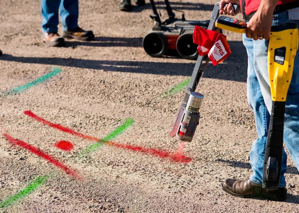
White lining is an age-old practice with a lot of possible flaws. This manual process is rife with inconsistency. Painted lines can easily fade, and be painted over, and temporary chalk lines are at the mercy of the elements. The result is a bygone practice that’s imprecise, temporary, and expensive to maintain. SiteMap® is dedicated to solving old problems with new solutions, without the hassle, the confusion, or the secrets. With SiteMap®, there are no secrets, just concrete data backed by amazing science. Electronic white lining is exactly what it sounds like, and it’s more useful than you’d think.
Utility Warnings
EWL may be used to help project managers and other professionals know where utilities are, and where they need to work. When you take traditional white lining and make it digital, you’re opening up a new world of possibilities, such as the ability for anyone on your team to carefully map and plan appropriate workflows. Instead of sending everyone running around to look at the ground, looking for scribbles and flags left in the dirt, they can simply open SiteMap®, and check where electronic white lines lay.
Streamlining the Process
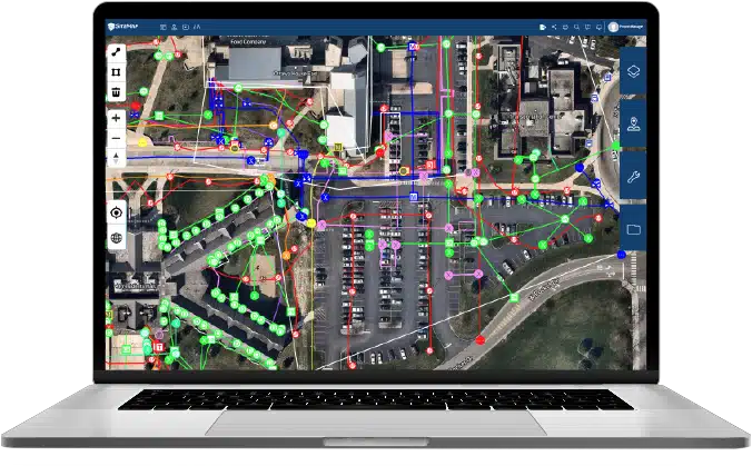
SiteMap® provides a centralized hub where digital plans and EWL data can live side by side, making the creation and editing of white lines inherently easier. SiteMap® makes reading in between the (white) lines easy, whether via your mobile phone or other device, crews can easily mark and read digital white lines from anywhere.
Accuracy and Efficiency
The precision of EWL is staggering. Digital white lines can’t fade, nor, are they easily tampered with inside SiteMap’s secure platform. This makes their accuracy better than ever before. When you combine this with the 99.8% accuracy of GPRS, digital white lines via SiteMap® are amazingly accurate and efficient.
Cost and Time Savings
A direct correlation exists between the implementation of SiteMap® and EWL and both time and cost savings. With instant updates and correction capabilities, reworks, change orders, and downtime are reduced. The cost of materials becomes almost negligible in comparison. SiteMap® also can hold your facility’s infrastructure and project data, from your as-builts to your locates, to your progress photos, and more.
Future Implications: What Lies on the Digital Horizon
The implications of SiteMap® technology and EWL go far beyond the current landscape of construction. As these tools become more sophisticated, they will play an ever more integral role in the construction, urban planning, and utility management industries.
The Connected Construction Site
The convergence of SiteMap® and GPRS with IoT (internet of things) devices, drones, and wearables heralds the creation of a fully connected construction environment where all activities, from white lining to material logistics, are intertwined. The possibilities are endless for a connected future powered by GPRS and SiteMap®.
Digital Workflows and Automation
With the further integration of AI and machine learning, SiteMap® platforms may one day automate the digital white lining process, assessing real-time data to suggest optimal paths and placements, reducing the need for manual intervention. While this is currently not in the works, SiteMap® is constantly looking for new ways to make utility management simple and safer.
Sustainability and Social Fabric
The inclusivity of spatial mapping technology allows for a broader consideration of social and environmental factors in construction planning. SiteMap® can be a powerful tool in fostering sustainable practices and preserving the social fabric of communities engaged in these projects. The world is rapidly changing and expanding, and SiteMap® is dedicated to being a leader in utility management and urban planning, fostering sustainability for generations to come.
SiteMap® and EWL represent the vanguard of a new age in construction. The benefits they offer are not only tangible in terms of efficiency and cost but also in enhancing the quality and precision of our built environments. As we stand at the cusp of wider adoption, the imperative for industry professionals is clear: embrace the change, invest in the right technology, and be ready for a future that’s not just shaped, but smartly mapped out, by digital innovation. Whether you’re a construction or facility manager overseeing a megaproject, a site engineer coordinating the latest build, or an urban planner weaving the fabric of the city, SiteMap® and EWL are the tools that will not just transform, but redefine, your craft.
This journey into the marvels of SiteMap® and the digital evolution of white lining in construction has offered a panoramic view of the digital frontier that lies ahead. The construction industry is standing on the precipice of a paradigm shift, and those who take the step forward with SiteMap® at their side will chart a course for success in the brave new world of construction cartography.
Are you ready to step into the future with SiteMap® Pro? Contact us today.