Infrastructure has changed a lot over the last fifty years alone. From towns with a few light pole, to bulging metropolises, things aren’t slowing down anytime soon. From urban development to transportation networks, the effective utilization of resources and the seamless operation of utilities can often be life or death. SiteMap® (patent pending), powered by GPRS, is a leading provider of utility mapping software, which has been at the forefront of innovation in this field. Leveraging Geographic Information Systems (GIS) technology, SiteMap® enables users to visualize, analyze, and manage subsurface utilities with unprecedented precision and efficiency. But what makes SiteMap® different from the others?

The Role of Site Mapping Software
Site mapping software plays a pivotal role in infrastructure management by providing a digital platform for the visualization and analysis of spatial data. Traditionally, utility mapping involved labor-intensive processes such as manual surveys, paper-based records, and physical inspections. However, the advent of site mapping software has revolutionized this landscape, offering advanced features such as interactive mapping, data integration, and accuracy in updates. SiteMap® stands out as a premier solution in this domain, offering a comprehensive suite of tools tailored to the unique needs of utility mapping and subsurface infrastructure management.
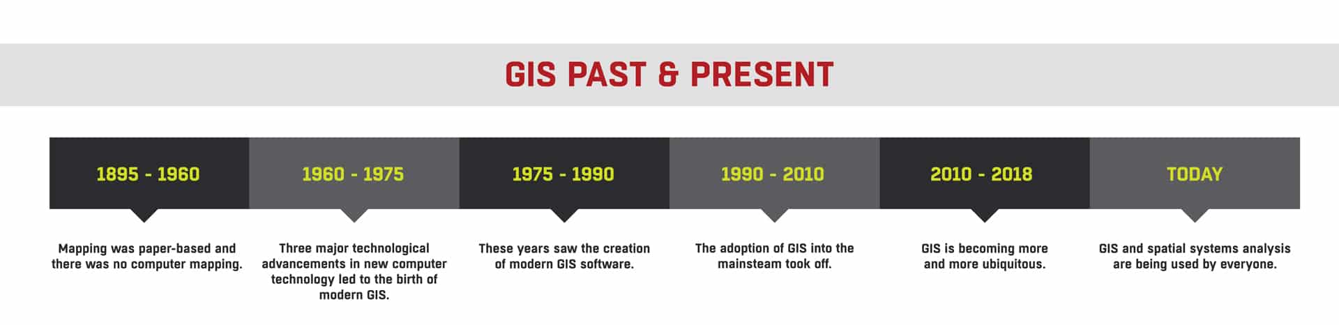
GIS: Past & Present
The first example of linking things in such a way takes us all the way back to 1854 and a cholera outbreak. People believed that the disease was being spread through the air. However, a quick-thinking English Doctor, Dr. Jon Snow, wasn’t so sure. Thus, he decided to map the outbreak locations, the roads, property boundaries, and the water pumps. By doing so, he made a startling discovery. A pattern of outbreak became clear. This pattern proved that the disease was not, in fact, airborne, but was being communicated via water and even more specifically by one infected water pump. John Snow’s cholera map was a major event connecting the what with the where. This wasn’t just the beginning of spatial analysis, but it marked a whole new field of study: Epidemiology. Snow’s work demonstrated that GIS is a problem-solving tool.
1854 – 1960
During the next hundred years or so, there was limited development in GIS. Mapping was paper-based and there was no computer mapping.
By the 1950s, maps were starting to be used in the vehicle industry.
1960 – 1975
In the period between 1960 to 1975 three major technological advancements in new computer technology led to the birth of modern GIS. These discoveries were:
- The ability to output map graphics using line printers
- Advances in data storage
- Advances in processing power of mainframe computers
Roger Tomlinson is widely dubbed as the “Father of GIS.” It was during his time with the Canadian Government in the 1960s that he came up with the concept of the Canadian Geographic Information System (CGIS). CGIS was unique because it implemented a layering approach to map handling.
The U.S. Census Bureau was also an early adopter of the core principles of GIS. The Bureau began to digitize Census boundaries, roads and urban areas.
In 1971, digital mapping was introduced to OS large-scale map production.
Since its birth in the 1960s, modern GIS has played an important role in the living space and social development of our society. The development of GIS is accompanied by the progress of information technology. GIS plays an important role in natural disaster management, which is an important direction of the development of next-generation GIS.
1975 – 1990
These years saw the creation of modern GIS software. In the mid-1970s, there was the first vector GIS called ODYSSEY GIS.
By the late 1970s, progress led to the first modern GIS Software.
1990 – 2010
The adoption of GIS into the mainstream took off between 1990-2010. This was facilitated by a number of IT advancements: computers were getting cheaper, faster and more powerful; there were an increasing number of GIS software options, and digitized mapping data was more readily available.
2010 – 2018
Due to the increased adoption of GIS over the previous twenty years, GIS data has become more and more ubiquitous.
Today
Today, Geographic Information Systems (GIS) and spatial analysis are being used by everyone, whether we realize it or not. GIS is nearly everywhere.
Organizations in nearly every field are using GIS to make maps that communicate, perform analysis, share information, and solve complex problems around the world. This is changing the way the world works.
Features of SiteMap® Utility Mapping Software
Interactive Mapping Interface
SiteMap® boasts an intuitive and user-friendly mapping interface that allows users to visualize underground utilities in real-time. By overlaying different layers of utility data onto a digital map, users can gain valuable insights into the spatial relationships and characteristics of subsurface infrastructure. Whether it’s water lines, sewer pipes, gas mains, or electrical cables, SiteMap® provides a comprehensive view of underground assets, enabling better decision-making and risk assessment.
Data Integration and Analysis
SiteMap® offers its own, but also offers data portability that allows you to utilize your existing GIS platforms as well. Depending on subscription level, users may be able to upload, edit, and analyze utility information in a centralized platform, facilitating collaboration and communication among project stakeholders. SiteMap® also offers advanced mapping and tools for spatial analysis, asset management, and more, empowering users to extract actionable insights from their data and optimize infrastructure planning and operations.
Mobile Accessibility
SiteMap® is available as a mobile application, allowing users to access utility maps and data directly from the field. Backed by GPRS technology, the mobile app enables field personnel to understand their location and navigate underground infrastructure with precision. Users can capture real-time observations, record asset information, and update project status on-the-go, enhancing data accuracy and workflow efficiency.
Subsurface Utility Mapping (SUE)
SiteMap® and GPRS do not offer SUE services, but we utilize technology that supports SUE QL-B, and that is the level of data provided in SiteMap®. By leveraging advanced technologies such as Ground Penetrating Radar (GPR), electromagnetic induction, and LiDAR 3D scanning, SiteMap® enables users to accurately locate, classify, and document underground utilities. This information is essential for avoiding utility conflicts, minimizing construction delays, and ensuring the safety of excavation activities.
The Impact of SiteMap® on Infrastructure Management
![]()
The adoption of SiteMap®-enabled utility mapping GIS software has had a transformative impact on infrastructure management across various sectors. By providing a centralized platform for data visualization, analysis, and collaboration, SiteMap® facilitates informed decision making, optimized resource allocation, and improved project outcomes. Whether it’s urban development, transportation planning, or utility maintenance, SiteMap® empowers users to navigate the complexities of infrastructure management with confidence and precision.
Innovations in infrastructure are essential for meeting the evolving needs of our communities and ensuring the sustainability of our built environment. SiteMap® utility mapping software represents a significant leap forward in this regard, offering a comprehensive solution for visualizing, analyzing, and managing subsurface utilities. With its advanced features, intuitive interface, and commitment to excellence, SiteMap® is poised to drive positive change and shape the future of infrastructure management. As technology continues to advance and urbanization accelerates, SiteMap® remains at the forefront of innovation, empowering users to map the path towards a more efficient, resilient, and sustainable infrastructure ecosystem.
Are you ready to interact with the subsurface? Contact SiteMap® today.