Infrastructure management has changed rapidly and continues to do so. The advent of digital mapping has upgraded the ability to effectively visualize, analyze, and manage assets. As urbanization rates continue to rise and infrastructure networks expand, the demand for innovative solutions to streamline asset management processes has never been greater. SiteMap® (patent pending), powered by GPRS, is a leading provider of GIS infrastructure mapping software. With its advanced features and intuitive interface, SiteMap® enables users to interact with detailed maps of underground utilities, streamline asset management workflows, and optimize infrastructure planning and operations.
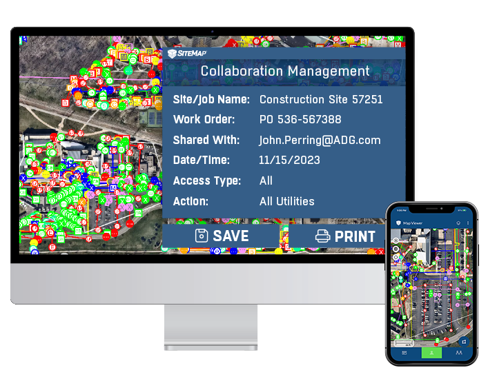
Actual demonstration of SiteMap® presentation across both mobile and desktop screens.
The Significance of GIS Mapping Software
GIS mapping software plays a crucial role in infrastructure asset management by providing a digital platform for storing, analyzing, and visualizing spatial data. Traditionally, asset managers relied on paper-based maps and manual processes to track and manage infrastructure assets. However, the advent of GIS mapping software has transformed this landscape, offering advanced features such as interactive mapping, data integration, and real-time updates. SiteMap® stands out as a premier solution in this domain, empowering users to utilize accurate, up-to-date maps of underground utilities and infrastructure assets.
There are four trends that are expected to forge the way in the world of GIS mapping and capabilities:
- Widespread advancements in location-based technologies: Accelerated progress in geospatial technologies, including location-based services, is expected to add impetus to GIS industry dynamics over the upcoming years. Moreover, the mounting use of cloud-based GIS platform is likely to further boost market growth.
- Penetration of GNSS systems in precision applications: With regards to component, the GIS market from the GNSS (Global Navigation Satellite System) antenna segment is projected to depict a commendable 10% CAGR through 2024. This is attributed largely to the novel frequencies and signals emerging in modern GNSS platforms, which will position the products as crucial components in GNSS receiver functioning.
- Innovative initiatives by prominent GIS industry players: The competitive landscape of the GIS industry is characterized by the emergence of numerous innovations in geospatial technology. Initiatives such as partnerships and product development are also likely to intensify competition in the overall business landscape. Platforms like SiteMap® are in line to take the lead, advancing the technology, and simplifying the methods.
- Development of sat-nav technologies in North America: On the regional front, the North America geographic information system (GIS) market is anticipated to hold more than 35% market share by 2024. This growth is ascribed mainly to the rapid growth of geospatial technology, including the introduction of novel satellite navigation systems.
Features of SiteMap® Underground Utility Mapping Software
Interactive Mapping Interface
SiteMap® boasts an intuitive and user-friendly mapping interface that allows users to visualize underground utilities with ease. By overlaying different layers of utility data onto a digital map, users can gain valuable insights into the spatial relationships and characteristics of subsurface infrastructure. This comprehensive view enables better decision making, risk assessment, and project planning.
As-Built Mapping
SiteMap® facilitates the creation of accurate as-built maps, enabling users to compare planned designs with actual construction data. This integration enhances accuracy and facilitates the identification of discrepancies or deviations from the original plans. By providing a clear understanding of the current state of infrastructure assets, SiteMap® empowers users to make informed decisions and prioritize maintenance and repair activities effectively.
Increase Communication
SiteMap® helps boost communication by creating a single source of truth that can be utilized by all key-players. SiteMap® users need no extra knowledge to properly utilize SiteMap® maps or technology. This helps break barriers, keeping all project managers, stakeholders, and field workers informed and safe.
Backed by GPRS
SiteMap® is the only infrastructure mapping software that has the outstanding power of GPRS behind it. Featuring detailed, aggregated, interactive maps and more, the data you interact with in SiteMap® is provided by the elite team of Project Managers employed by GPRS. This team has earned a 99.8% accuracy rating across over 500,000 jobs nationwide. No other software can currently claim this level of verifiable accuracy. GPRS is in pursuit of a world with 100% subsurface damage prevention. Our 99.8% accuracy rate for ground penetrating radar services (GPR), utility locating services, utility mapping services, and concrete scanning services will locate critical targets like underground utilities, post tension cables, rebar, conduits, underground storage tanks (USTs), and more to help keep your project on time, on budget, and safe.
The Impact of SiteMap® on Asset Management

The adoption of SiteMap® underground utility mapping software has had a transformative impact on infrastructure asset management across various sectors. By providing a centralized platform for data visualization, analysis, and collaboration, SiteMap® facilitates informed decision-making, optimized resource allocation, and improved project outcomes. Whether it’s urban development, transportation planning, or utility maintenance, SiteMap® empowers users to navigate the complexities of asset management with confidence and precision.
Looking Ahead
According to a report by MarketsandMarkets, the global GIS market size is expected to reach $14.5 billion by 2025, growing at a CAGR of 12.4% from 2020 to 2025.
A survey conducted by the American Society of Civil Engineers (ASCE) found that 44% of respondents cited GIS technology as critical to their organization’s infrastructure management efforts.
The Environmental Protection Agency (EPA) estimates that aging and deteriorating infrastructure systems will require an investment of $660 billion over the next 20 years to maintain current levels of service.
These are just a few of the many studies and statistics that support the claim for a very real need for enhanced infrastructure management systems.
As infrastructure systems continue to evolve and expand, the need for effective asset management solutions becomes increasingly apparent. SiteMap® represents a significant leap forward in this regard, offering a comprehensive solution for visualizing, analyzing, and managing infrastructure assets. With its advanced features, intuitive interface, and commitment to excellence, SiteMap® is poised to drive positive change and shape the future of asset management.
With SiteMap®, the subsurface becomes more simple and accessible. Are you looking for a way to revolutionize your asset management? Contact SiteMap® today.