Everything is about efficiency. From predicting traffic light changes to optimizing manufacturing processes, technology has continually aimed to streamline operations and improve outcomes. Since the invention of fire, humanity has been putting two and three together to make five, and then starting over again. One such innovation making waves in the utility sector is the concept of digital twins. According to the definition by IBM, a digital twin is “a virtual representation of an object or system designed to reflect a physical object accurately.” Let’s delve into how Digital Twins, and particularly the combination use of SiteMap® (patent pending), powered by GPRS, is revolutionizing infrastructure management for water utilities.

Understanding Digital Twins
According to IBM, a digital twin is more than just a virtual replica; it’s a dynamic virtual model designed to mirror a physical object or system accurately. Digital twins come in various forms, depending on their use case. They can be known as:
- Component twins
- Asset twins
- System twins
- Process twins
For water utilities, digital twins offer a holistic view of subsurface pipe infrastructure, enabling better decision-making and predictive maintenance. SiteMap® helps you intelligently visualize your underground utilities, including water and sewer, and is backed by the 99.8% accurate subsurface utility data provided by GPRS.
Dispelling Myths
As with any emerging technology, digital twins are surrounded by misconceptions. It’s unsurprising, as new technologies often require time to be accepted. It’s easy to get wrapped up in misconceptions about a new technology. So, let’s address some prevalent myths:
Just Virtual Replicas:
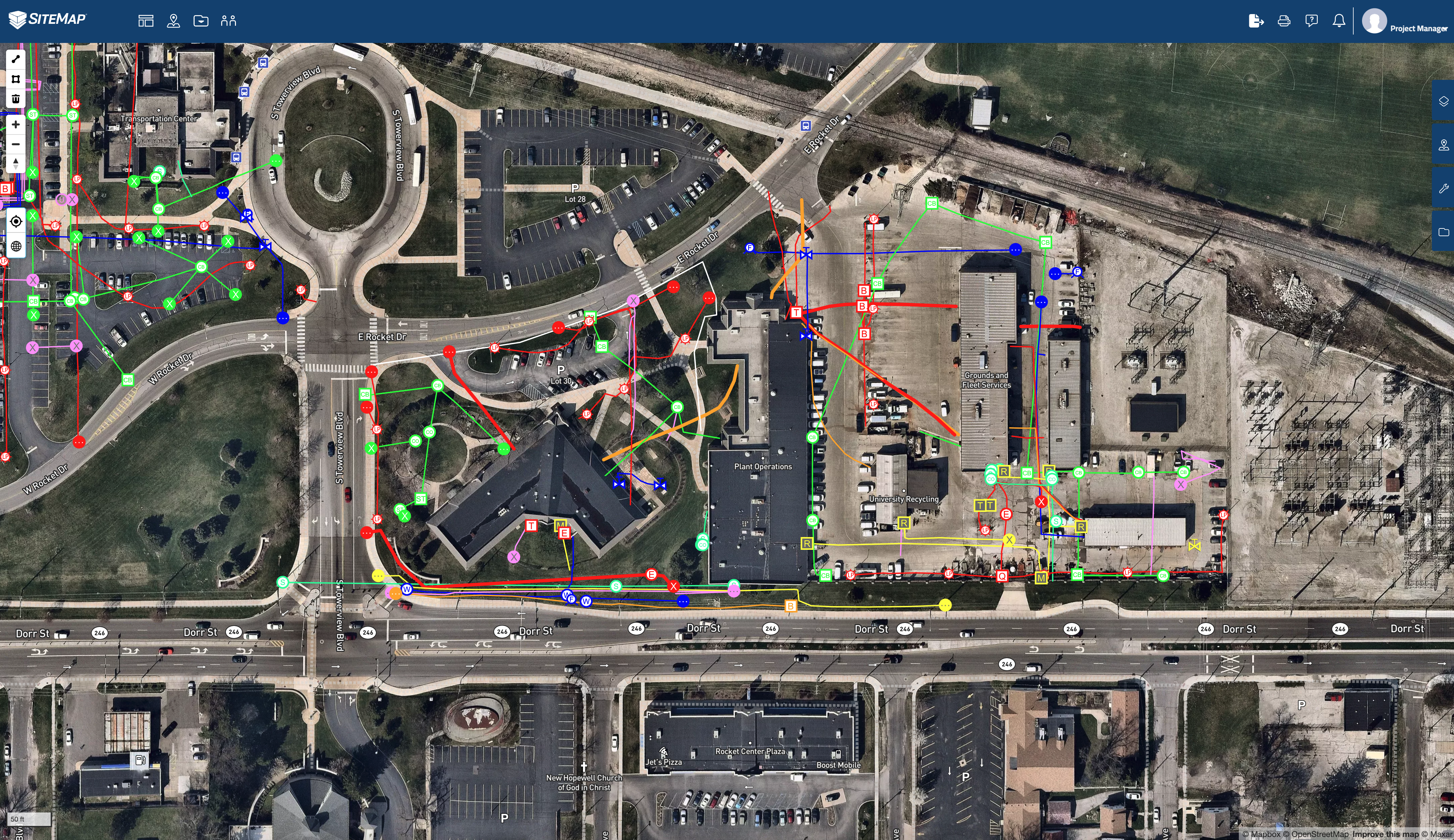
Example of layered subsurface utility data in SiteMap, powered by GPRS
Digital twins often go beyond mere 3D models; they integrate real-time and accurate data from multiple new technologies and can include information updates from the use of sensors and simulations to provide actionable insights. GPRS can provide digital twins and/or 3D BIM models that incorporate both subsurface and aboveground features, and can even integrate your design/plan specifications into your mode, to help you determine the accuracy of your plans before you even break ground.
Exclusive to High-Tech Industries:
While initially prevalent in aerospace and manufacturing, digital twins now find applications across diverse sectors, including water utilities. There are multiple fields that can benefit from digital twins, even artists may find ways to benefit from the use of this unique technology. One of the most helpful innovations provided by GPRS and delivered via SiteMap is the ability to accurately map and measure complex pipe runs and to provide that data in a variety of formats to allow you to plan, maintain, and expand more easily.
Reserved for Large Enterprises:
Despite initial perceptions, small to medium-sized businesses can harness digital twins to optimize operations and reduce costs. Digital twins are more accessible and useful than once believed. SiteMap® also ensures that accurate visualized data is available for anyone who needs it, no matter their experience or skill level. SiteMap® allows the licensed user to secure their sensitive site data, and to share it with only those they choose, only for as long as they need it, which makes communication and collaboration simple.
One-Time Investment:

Maintaining digital twins requires ongoing updates and investment in technology and infrastructure. The world around you is ever-changing, so creating flexible processes to update your digital twin should be part of your long-term planning. Consider digital twins like human twins, you have to invest in them as they grow and change to keep them healthy and happy.
Silver Bullet Solution:
While powerful, digital twins are part of a broader tech ecosystem, requiring integration with AI, machine learning, and data analytics like dashboards and GIS platforms. There are many aspects that you need to take into account when developing the big picture scope of your project, or planning for scale, and digital twins play a part, but are not the only answer.
Require Large Upfront Investment:
Cost-effective solutions exist for implementing digital twins tailored to specific organizational needs. As detailed previously, your digital twin could be customized to serve a number of purposes, keeping your wallet and your end goals in mind.
Synergy with Digital Transformation:
Digital twins complement broader digital transformation initiatives, fostering innovation and resilience within water utilities. The use of digital twins in accurately mapping water treatment plants, distribution hubs, and subsurface lines can streamline processes around the new 10-year “Get The Lead Out” initiative proposed by the federal government. Your model can allow you to label your pipe inventory so that it is easily read, and each pipe is traceable, upstream or down. Mapping an entire water or sewer system gives everyone responsible for managing the safe distribution of clean water a common touchstone and an easily observable object with which to plan.SiteMap® is part of this digital transformation, providing accurate and aggregated visuals that anyone can understand.
Data Versatility:
Digital twins operate efficiently with real-time, near-real-time, or can utilize historical data to enhance accuracy and predictive capabilities. What path you take depends on which platforms and technologies are utilized. SiteMap® provides access to accurate infrastructure data, often within just five minutes after locate completion. However, it is crucial to understand that your system will change and degrade over time, and so, your digital twin will need to be updated at least once every 1-2 years, or when major changes occur. GPRS is comprehensive in their approach, with an elite national Project Management team that gives you 500 pairs of real boots on the ground, completing over 100,000 jobs annually. This gives you access to accurate data, fleshed out in new and exciting ways, accessible through the user-friendly SiteMap®.
SiteMap®: A Game-Changer in Water Infrastructure Management

Pumping and distribution system operations are crucial for ensuring the reliable and efficient supply of water and other essential resources to communities, industries, and agricultural areas
SiteMap® stands out as a leading infrastructure asset management software, specializing in 3D utility mapping. By leveraging digital twin technology, SiteMap® offers water utilities a comprehensive view of their infrastructure, above and below ground, to facilitate proactive maintenance, and optimize resource allocation. Project managers can rest easy knowing that the data they see in SiteMap® is accurate, captured by GPRS using a suite of complementary technologies like GPR, drone use, 3D laser scanning, CCTV pipe inspection, and much more.
SiteMap® allows you to quickly access, view, and share your infrastructure data securely with subcontractors, engineers, and your team. All of your utility, structural, water & sewer, and facility information is uploaded into the SiteMap® Map Viewer and Digital Plan Room. You can document construction progress with ProCap Progressive Capture, which utilizes 3D photogrammetry to track the evolution of the site and document key project milestones. Virtual Tours like WalkThru 3D allow you to virtually walk-through a site or facility in minutes, take basic measurements, estimate clearances and distances, and add digital notes.
Digital twins have the potential to provide a landmark shift in water utility management, from pumping and distribution to planning and building, and more. With SiteMap®, these digital twins and processes become more accurate, easier to communicate, and easier to plan.
Float With SiteMap®
SiteMap® provides an innovative and comprehensive solution for mapping water utilities with unparalleled precision and efficiency. Leveraging advanced GIS mapping software, SiteMap® enables utilities to access detailed and accurate 3D representations of their water infrastructure. This includes mapping individual components, entire assets, system interconnections, pipe runs, and processes, fostering a holistic understanding of the water utility network.
SiteMap’s user-friendly interface streamlines the mapping process, allowing utility professionals to easily navigate and manipulate intricate spatial data. Whether it’s identifying the exact location of critical components or visualizing the entire water distribution system, SiteMap® serves as a powerful tool for utility managers to optimize infrastructure planning, but also to aid in the creation of impressive digital twins, taking the data one step further.
Digital twins represent an impressive shift in infrastructure management for water utilities. By dispelling myths and embracing facts, organizations can harness this technology to enhance efficiency, resilience, and customer satisfaction. SiteMap® exemplifies the potential of digital twins, ushering in a new era of proactive water and sewer infrastructure management. As we continue to navigate the complexities of modern utilities, embracing digital twins will surely be as common as radio waves.
Are you looking for a comprehensive infrastructure solution? See the subsurface simply with SiteMap®. Contact us today.