Every project starts with a solid foundation – and that foundation often lies beneath the surface. A foundation must be tailored to the job, with each one being specific to the location, construction needs, and features of the land. The same could be said in regards to site data and facility management. If your foundation isn’t strong, your build will crumble before your eyes. Without understanding, properly visualizing, and interacting with the very bones of a site, the rest of your project is asking for trouble. The intricate network of underground utilities, pipelines, and structures forms the lifeline of any construction endeavor. However, without proper knowledge and management of these subterranean assets, projects can quickly encounter setbacks, delays, and safety hazards.
This is where Ground Penetrating Radar Systems (GPRS) steps in, offering comprehensive solutions for precision utility mapping and facility management, such as SiteMap® (patent pending). Through the lens of SiteMap®, the subsurface becomes clear.
Understanding the Landscape: Mapping Underground Utilities
Before breaking ground on any construction project, it’s essential to have a clear picture of what lies beneath. Traditional methods of utility mapping often involve outdated blueprints, incomplete records, and costly trial-and-error approaches. GPRS revolutionizes this process by harnessing an advanced suite of technologies and training to penetrate the ground and create detailed, accurate maps of underground utilities.
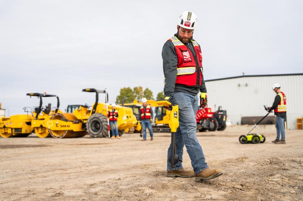
GPRS employs groundbreaking technologies like ground penetrating radar (GPR), electromagnetic locators, CCTV video cameras, acoustic water leak locators and other equipment to scan for subsurface utilities, including depths and GPS mapping, saving time, money, and even lives by avoiding utility strikes to protect all site employees and contractors from potential line strike damages. GPRS provides complimentary .KMZ files for all of our exterior utility locating projects. Our utility mapping services can create an updated as-built drawing for your campus or facility. GPR services can also be used to locate underground storage tanks (USTs), unknown utilities, and even manholes and well heads.
When you hire GPRS, you’re given your own SiteMap® Personal account, so you can view & securely share your utility information with your team.
Why Precision Utility Mapping?
Precision utility mapping enables stakeholders to:
Mitigate Risks:
By accurately identifying the location of underground utilities, construction teams can avoid accidental damage during excavation, reducing the risk of costly repairs and ensuring compliance with safety regulations. 67% of facility managers report experiencing a utility strike or locating issue in the last five years. That number is far too high when GPRS exists. GPRS helps reduce the risk of disaster with a 99.8% accuracy rating across hundreds of thousands of jobs nationwide.
Optimize Planning:
Armed with precise data on utility locations, project managers can streamline planning processes, allocate resources more efficiently, and minimize disruptions to existing infrastructure. Planning is important, companies that effectively plan and execute their strategies are 2.5 times more likely to achieve their goals than those that don’t. When plans can cause life or death consequences, it’s always best to make sure that everyone is on the same page at all times. GPRS and SiteMap® make keeping everyone from investors to field team members updated as easy and efficient as possible.
Enhance Decision Making:
With real-time insights into underground assets, stakeholders can make informed decisions regarding project design, route optimization, and construction methodologies, ultimately improving project outcomes and reducing overall costs.
Every decision you make on a job site can cost time, money, and even lives. That’s why GPRS maintains a consistent 99.8%+ accuracy rate in utility locating and concrete scanning & imaging. Because it’s our job to help you keep your jobs on time, on budget, and safe. Our nationwide team of elite SIM-certified Project Managers aren’t just expert technicians – they are consultants who help you get what you need to do the job right, and safely.
SiteMap®: Empowering Stakeholders with Utility Mapping Software
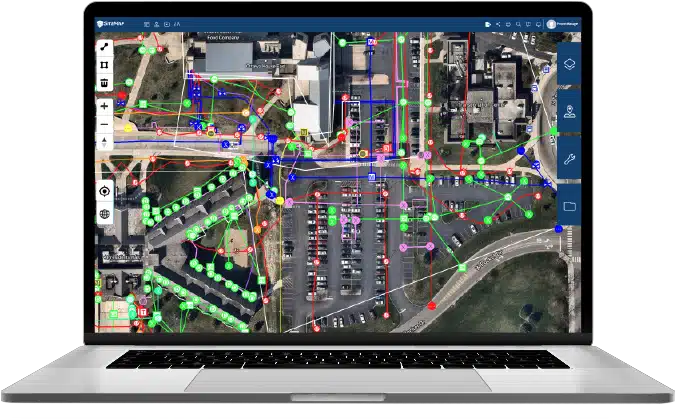
As part of GPRS’ commitment to spectacular customer service, they created SiteMap®: an advanced, easy to use, infrastructure data management platform that stands out as a trailblazer in utility mapping software. Leveraging cutting-edge technology and a user-friendly interface, SiteMap® offers a comprehensive load of visualizations and data points tailored to the unique needs of construction and facility management professionals. Much like any good foundation, SiteMap® helps you build upon the subsurface, utilizing the data of the world around you to build up a better tomorrow.
Key features of SiteMap® include:
Interactive Mapping: SiteMap’s intuitive mapping interface allows users to visualize underground utilities with customizable layers for enhanced clarity and precision. Your data is aggregated, and is stored for the lifetime of your project. Certain tiers may also have access to historical data, allowing you to switch between even more layers and data points
Data Portability: Seamlessly blend your existing GIS data/system, CAD drawings, and survey information into SiteMap’s platform, or vise versa, ensuring a unified and holistic view of underground assets. GPRS’ in-house Mapping & Modeling Team offers everything you need to see the subsurface, and your above ground facilities and structures, in startling accuracy and detail.
Advanced Analytics: SiteMap® goes beyond basic mapping functionalities, offering data that can be used for advanced analytics for trend analysis, predictive modeling, and scenario planning, empowering stakeholders to anticipate challenges and optimize project outcomes.
Mobile Accessibility: With SiteMap’s mobile app, field technicians can access vital utility data on-site, enabling quick decision-making, collaborative problem-solving, and seamless communication across project teams. In fact, SiteMap® was built with mobility in mind!
GPRS products like SiteMap® are indispensable tools for navigating the complex landscape of facility management and construction site data. By utilizing the amazing power of ground-penetrating radar technology, NASSCO certified CCTV-pipe inspection, drone imagery, 3D laser scanning, and more, stakeholders can unlock new possibilities for efficiency, safety, and success.
Whether embarking on a new construction project or managing existing infrastructure, the ability to see your job site as a whole is crucial. From the subsurface and beyond, GPRS is making seeing and interacting with your jobsite simple.
Take the step toward a future where 100% damage prevention is reality, take that step with GPRS. Contact us today.