The surge of smart city initiatives globally has ushered in an era of unprecedented urban transformation. Smart city initiatives encompass comprehensive efforts to leverage advanced technologies and data-driven solutions to enhance the efficiency, sustainability, and overall quality of urban living. These initiatives integrate cutting-edge technologies such as the Internet of Things (IoT), artificial intelligence, and data analytics into various aspects of city infrastructure and services.
As municipalities embrace the digital shift, the importance of precise and reliable infrastructure mapping cannot be overstated. It serves as the bedrock for intelligent decision-making and efficient public service management. SiteMap® (patent pending), powered by GPRS, is the next-level solution poised to revolutionize how we understand and interact with our cities’ unseen utility skeleton.

Smart city initiatives integrate technology to enhance urban living, fostering efficiency, sustainability, and connectivity for a brighter future.
Understanding SiteMap®
SiteMap® isn’t just another mapping system; it’s an indispensable tool for the modern urban ecosystem. Where once utility workers and city planners stumbled through outdated records, SiteMap® provides an accurate, live look into the city’s veins and arteries with the assistance of robust GPRS technology, which boasts an impressive 99.8% accuracy rating across 500,000 jobs nationwide.
How Does SiteMap® Work?
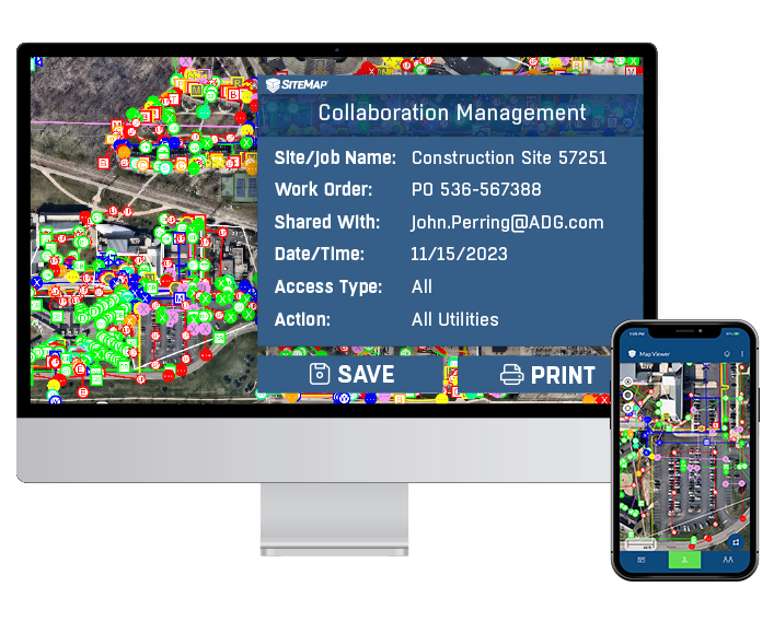
SiteMap® taps into the power of the accurate GPRS-powered data to deliver detailed, accurate, easy-to-read underground utility maps, existing conditions documentation, and visualizations. Occupying the forefront of mapping innovation, it grants users the ability to pinpoint utility infrastructure locations with unrivaled precision, thereby minimizing human error and maximizing operational efficiency.
When you order locate services with GPRS, you’ll be prompted to sign up for SiteMap® because all GPRS customers are given access to a SiteMap® Personal subscription. You also have the option to upgrade, unlocking additional functionality and benefits. Once your locate job is complete, your GPRS data is available for easy access in your SiteMap® account, often within five minutes of completion. This data is aggregated, labeled, and accessible from your computer, tablet, or mobile device. You’ll be able to study your data accurately and piece by piece, furthering communication and understanding.
Benefits of SiteMap® in Smart Cities
Improved Infrastructure Planning and Development
Intelligent planning is at the core of smart city evolution. SiteMap® equips planners with the insights needed to strategize future developments without compromising the existing utility framework. 60% of the world’s population is expected to live in smart cities by 2050, which means the demand for accurate and improved planning and development will become more crucial by the year. SiteMap® can help fuel this by providing accurate and well-mapped insights without the need for high-impact or invasive practices.
Enhanced Utility Management and Maintenance
Project and utility managers can easily annotate and track their utilities and maintenance by utilizing SiteMap®. When the web that lies beneath is easily visible, it’s also easily trackable, which makes management and maintenance easier as well. Simplifying this process is crucial for a smart city, where infrastructure is paramount, and space is limited.
Increased Efficiency and Cost Savings
By avoiding accidental damages and expediting construction timelines, SiteMap® usage translates into considerable cost savings for local governments and stakeholders. 66% of US cities are investing in smart city technology, while 55% of Americans think investing in smart city technology is a good use of taxpayer dollars.Using those dollars wisely is important. SiteMap helps prevent utility strikes, which not only saves lives but also money and time.
With incidents on the rise, underground facilities must be understood and accurately located. According to the Common Ground Alliance’s 2022 DIRT Report, U.S. damage counts from consistently reporting organizations have increased over the past 3 years, with 163,726 damage incidents in 2022 alone. Having an accurate map of your subsurface infrastructure helps you avoid subsurface damage by telling you where it’s safe to excavate, and where digging could have disastrous consequences.
Accurate Data for Decision-Making
SiteMap® isn’t just about mapping; it’s about informed governance. With accurate GPRS-backed data, policymakers, and service providers can make agile, data-driven decisions to serve their communities better. If you understand something very well, you’re more likely to make a better decision about it. Hindsight is 20/20, but SiteMap® helps seeing the unseen a lot easier.
Smart city initiatives optimize infrastructure through technology, enhancing resource management and resilience for sustainable urban development.
The Resonance of SiteMap® with Smart Cities
Melding seamlessly with smart city frameworks, SiteMap® directly addresses the complex challenges of urban management. For instance, it can enable cities to seamlessly integrate new technological utilities into the existing grid, ensuring that the march towards modernization doesn’t trample over past investments. Plus, SiteMap® provides data portability that melds with any existing GIS platform you’re using. However, unlike the GIS systems used by most municipalities, SiteMap’s documentation is exportable, which is a game-changer in the industry.
When you’re able to see what’s already there, it’s a lot easier to plan for what is to come. By allowing utilities to be tracked, seen, and shared, project managers can properly integrate smart city systems and utilities into the grid, without interference or issue. Geospatial technology has a huge place in the creation of smart cities, but only when done correctly. SiteMap® takes the data collected by GPRS and makes it accessible to those who need it when they need it. These visualizations are easy to understand, which means planning the smart cities of tomorrow is easier as well.
Market Trends and Statistics
The optimistic forecasts for the Smart Cities market suggest a burgeoning demand for innovative technology solutions like SiteMap®. Booming to an expected $820.7 billion by 2025, this realm beckons for tools that promise accuracy and agility. Utility mapping plays a vital part, as indicated by the Global Utility Locator Market‘s steady growth. With over 500 cities poised to onboard smart tech in the coming years, per Northeast Group’s study, SiteMap® stands at the vanguard, ready to answer the call for scalable, reliable infrastructure mapping.
As we enter the precipice of urban futurism, solutions like SiteMap® empower us to leap confidently, knowing the ground beneath our cities is understood and well-charted.
Ready to learn how you can plan, design, manage, and dig better? Contact SiteMap today to learn more about how our solutions can help you visualize and shape the resilient, efficient cities of the future.
Learn more about SiteMap® and our capabilities, contact us today.