The art of visualization goes back over 200 years, with studies on modern visualization techniques dating back to at least the 1960s. Jacques Bertin’s Sémiologie Graphique (Semiology of Graphics), which was published in 1969, was the first systematic treatment regarding the different ways graphical representations encode data. Bertin coined many terms of the trade, and defined a number of retinal variables. This science has evolved, and plays a core part in proper utility visualization. Visualization is important, and has been helping us make decisions for eons. Intelligent Visualization®, which GPRS provides its customers, is the evolution that is changing how construction, facility management, and related industries see and interact with their infrastructure data.
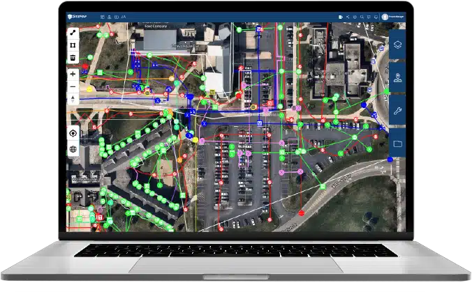
Effective infrastructure management is crucial for ensuring the reliability, safety, and sustainability of our towns and cities. An important aspect of this management is the ability to accurately visualize and analyze infrastructure assets, including utilities such as water and sewer lines, electrical cables, and telecommunications networks. This is where GIS (Geographic Information Systems) mapping software, such as SiteMap® (patent pending), powered by GPRS, comes into play. How does SiteMap® lead the way in digital utility mapping? What makes seeing with SiteMap® different?
The Importance of Visualizing Infrastructure
Visualizing infrastructure assets is crucial for understanding their spatial relationships, identifying potential conflicts, and making informed decisions about maintenance, upgrades, and expansions. Here’s why visualizing infrastructure is essential:
Spatial Understanding: Visual representations of infrastructure assets provide stakeholders with a clear understanding of their location, extent, and interconnections. This spatial understanding is critical for planning and executing construction projects, managing utility networks, and responding to emergencies.
Conflict Identification: Visualizing infrastructure assets helps identify potential conflicts with other underground utilities, environmental features, or land use regulations. By visualizing these conflicts early in the planning process, organizations can avoid costly delays, redesigns, and disruptions to service delivery.
Data Analysis: GIS mapping software enables organizations to analyze spatial data to identify trends, patterns, and anomalies in infrastructure performance. By visualizing this data on maps, organizations can gain valuable insights into asset condition, usage patterns, and maintenance requirements, informing strategic decision-making and resource allocation.
According to the University of Minnesota, the Human brain processes visuals 60,000 times faster than textual information, meaning that visual information is easier and faster to understand. Not only do people process visual information faster, but visuals can increase learning and information retention by 78% and 80% of researchers saw a decrease in errors when using visuals to explain a task.
By using visualization to convey subsurface infrastructure data, we can reach those who learn and absorb information in different ways, keeping everyone on the same page. Visualization helps to convey information easily, accurately, and quickly, helping to aid decision making and keep crews, cities, and our infrastructure safe.
The Power of GIS Mapping Software
GIS mapping software revolutionizes the way organizations visualize and analyze infrastructure assets, offering advanced capabilities for data collection, integration, visualization, and analysis. SiteMap® empowers organizations by offering precision utility mapping. As more than just an underground utility mapping software, SiteMap® has power in a lot of ways and applications:
Digital Utility Mapping
SiteMap® enables organizations to carefully study digital maps of underground utilities, accurately depicting their location, depth, type, and condition. By digitizing utility maps, organizations can access and update information more easily, reducing reliance on paper records and manual surveys. Digital utility mapping improves data accuracy, accessibility, and usability, enhancing decision-making and operational efficiency.
Precision Utility Mapping
SiteMap® offers precision utility mapping capabilities, allowing organizations to interact with mapped and aggregated utilities with unprecedented accuracy and detail. Precision utility mapping minimizes the risk of utility strikes, damage, and service disruptions during construction activities. By mapping utilities with precision, organizations can optimize excavation, minimize downtime, and ensure the safety and integrity of underground infrastructure.
Underground Utility Mapping Software
SiteMap® serves as a comprehensive underground utility mapping software solution, providing sources for accurate data collection, integration, visualization, and analysis. With SiteMap®, organizations can interact with high-resolution maps of underground utilities, monitor asset changes, and analyze historical data to identify trends and patterns(with certain account tiers.)
Underground utility mapping software enhances situational awareness, facilitates informed decision-making, and improves regulatory compliance, ultimately leading to more resilient and sustainable infrastructure networks.
The Impact of SiteMap® in Visualizing Infrastructure
SiteMap® stands out as more than just a leading GIS mapping software solution, empowering organizations to visualize infrastructure with unparalleled accuracy and efficiency. Here’s how SiteMap® makes a difference:
Advanced Features: SiteMap® offers a wide range of advanced features for digital utility mapping, precision utility mapping, and underground utility mapping software, including high-resolution mapping, aggregated data, 99.8% accurate data, and more.
Ease of Use: Despite its advanced capabilities, SiteMap® is designed to be user friendly and intuitive, allowing organizations to quickly learn and master the software with minimal training or technical expertise.
Scalability: SiteMap® is scalable to meet the needs of organizations of all sizes and industries, from small municipalities to large utilities and engineering firms.
Data Portability: SiteMap® gives you seamless data portability with existing systems and tools, such as other GIS platforms, maximizing the value of infrastructure data and investments.
The GPRS Difference: Because SiteMap® is a GPRS product, users get access to the skill, professionalism, and accuracy of GPRS. GPRS is in pursuit of 100% subsurface damage prevention. Our 99.8% accuracy rate demonstrates that our equipment, training, and methodology consistently deliver high-quality results nationwide. All 500+ GPRS Project Managers utilize the industry-leading specification called Subsurface Investigation Methodology (SIM) when conducting utility mapping, concrete scanning, sewer camera inspection, or 3D laser scanning
GIS mapping software, such as SiteMap®, plays a pivotal role in visualizing infrastructure, enabling organizations to make informed decisions about the management, maintenance, and optimization of infrastructure assets. By leveraging digital utility mapping software, organizations can enhance their spatial understanding, identify potential conflicts, and analyze data to drive strategic decision-making and improve operational efficiency. As the importance of visualizing infrastructure continues to grow, solutions like SiteMap® will remain indispensable for navigating the complexities of infrastructure management and building well-planned cities of tomorrow. SiteMap® is here to help users see the subsurface simply, offering in-depth visualization of your locate jobs, allowing users to understand the world below, to help aid in the creation of our world above.
Are you ready to harness the power of GIS mapping software such as SiteMap®? Contact us today to learn more.