Dieser Satz wurde auf Deutsch geschrieben. Which translates to, “That sentence was written in German,” and while it may not be quite right for the USA, it’s not wrong either. It’s merely different. Regional differences exist within every facet of our collective human experience, and infrastructure markings are no different.
Understanding the complexities of underground infrastructure allows construction crews nationwide to ensure safe and efficient operations. Across the United States, construction sites are marked with color-coded flags or other field markings, representing various subsurface utilities, such as water lines, sewer systems, gas, and electric lines. These markings serve as a visual guide for construction crews, indicating the presence and type of underground infrastructure in a particular area.
However, the color codes used for utility marking can vary regionally, leading to confusion and potential safety hazards. To address this challenge, SiteMap® (patent pending), powered by GPRS, offers innovative solutions to enhance infrastructure understanding and mitigate risks associated with regional marking differences.
The 411 on 811
![]()
Construction crews rely on the 811 One Call hotline system to obtain utility locates from public utility locating contractors before digging, because it is the law and a crucial safety measure. The 811 system has implemented specific color codes for marking utility locates nationwide, ensuring consistency and clarity across different regions. However, while 811 locates public utility lines, private property lines are not included in these markings, highlighting the importance of additional measures for comprehensive infrastructure understanding. Here, SiteMap® plays an important role by providing advanced GIS mapping capabilities, enabling construction professionals to visualize and interpret infrastructure data with precision and accuracy. This is even more important for private utilities, who often don’t have access to the same level of data that public utilities may.
The Colors Of SiteMap®
With underground utility lines varying in depth across different regions of the United States, it is essential to have accurate information about their location and depth before excavation. While the 811 system provides utility locates, it does not always include information about the depth of utility lines. And sometimes, the data given by a public utility locator is incorrect. SiteMap® addresses this gap by utilizing multiple forms of technology, utilized by the skilled Project Managers at GPRS to achieve 99.8%+ accuracy in utility locating. These technologies include (but aren’t limited to) Ground Penetrating Radar (GPR) and Electromagnetic (EM) Utility Locators, to pinpoint underground utilities accurately. By adhering to industry-leading Subsurface Investigative Methodology (SIM), SiteMap® provides construction crews with comprehensive information about the location and depth of utility lines, ensuring safe and efficient excavation practices.
Once utility lines are located and accurately mapped, construction crews rely on color-coded flags and spray-painted lines to identify the location of underground utilities on site. However, differences in regional marking standards can lead to confusion and potential safety hazards. SiteMap® integrates the guidelines established by the American Public Works Association (APWA) for color marking utility locates as part of its Subsurface Investigation Methodology protocols, ensuring consistency and clarity across different regions. By following these nationwide guidelines, construction crews can interpret utility markings accurately, minimizing the risk of utility strikes and ensuring the safety of workers and bystanders on site.
Markings of Many Colors
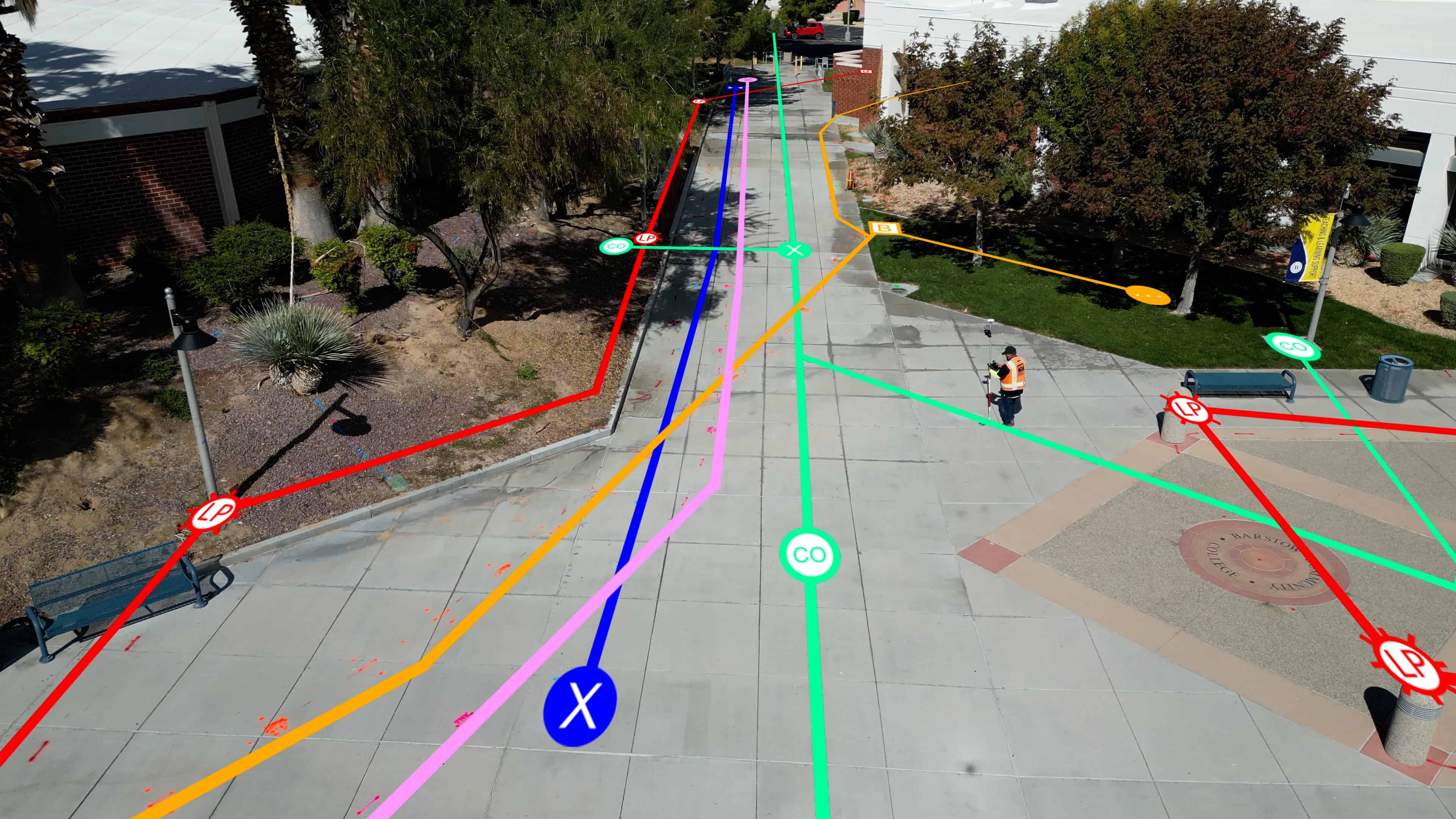
Real life example of GPRS on site locating and scanning a jobsite, with overlays of utility markings
As mentioned above, different colors typically represent different things. While these colors can differ, standards have been set to try and prevent these differences, at least within public infrastructure. The APWA’s “Uniform Temporary Marking of Underground Facilities” recommends the specific color code that should be used to mark the location of underground facilities, temporary survey markings, and intended excavation sites. When a utility company marks a location, they are advised to include a color code that consists of White, Pink, Blue, Green, Yellow, Orange, Red, and Purple color markings of both flags and spray paint to represent what each of the lines located represent.
Yellow Flag
What does a yellow utility flag stand for?
A yellow utility flag stands for natural gas and oil, steam, petroleum, or other gaseous or flammable materials.
Red Flag
What does a red utility flag stand for?
A red utility flag stands for electric power lines, cables, or conduit, and lighting cables.
Orange Flag
What does an orange utility flag stand for?
An orange utility flag stands for phone and telecommunication lines, alarm or signal lines, cables or conduits, and fiber optics.
Blue Flag
What does a blue utility flag mean?
A blue utility flag stands for potable (drinking) water.
Green Flag
What does a green utility flag mean?
A green utility flag stands for storm and sanitary sewers, drainage facilities,or other drain lines.
Purple Flag
What does a purple utility line stand for?
A purple utility flag stands for reclaimed water, irrigation, and slurry lines
White Flag
What does a white utility flag mean?
A white utility flag means pre-marking of the outer limits of the proposed excavation or marking the centerline and width of proposed lineal installations of buried facilities.(proposed excavation limits or route)
Pink Flag
What does a pink utility flag mean?
Pink utility flags are for temporary survey markings, unknown / unidentified facilities
SiteMap’s Role in Accuracy

SiteMap® uses APWA’s standard when integrating these markings into SiteMap maps and visuals. This helps project managers and other professionals quickly and easily identify which utility exists where. SiteMap® offers more than just colors, offering aggregated and carefully mapped visuals backed by GPRS’ 99.8% accurate data. This means that those using SiteMap® get accurate, easy to understand data that can be shared easily and seamlessly with their entire team, helping prevent utility strikes and delays.
Once you sign up for a locate job with GPRS, our elite team of Project Managers get to work carefully mapping every inch of your specified work area or jobsite. This data is then available in your SiteMap® account often within just a few minutes of job completion. Depending on your account tier, you may even have access to extra features, including the ability to add and see historical data, creating a single source of truth for everyone involved. GPRS is committed to accuracy and safety, and utilizing APWA’s color standards is just one piece of the puzzle that makes SiteMap® one of the best infrastructure mapping solutions.
SiteMap® plays a crucial role in enhancing infrastructure understanding and mitigating risks associated with regional marking differences. By providing advanced GIS mapping capabilities, and adhering to industry standards for utility marking, SiteMap® enables construction professionals to visualize and interpret infrastructure data accurately, ensuring safe and efficient construction practices. With SiteMap®, construction crews can navigate regional marking differences with confidence, minimizing the risk of utility strikes and enhancing overall project safety and success.
Let us show you our true colors, contact SiteMap® today to simplify your jobsite.