The construction industry is often associated with hard hats and heavy machinery, yet in our digital age, it’s increasingly a story of bytes and bandwidth. The quest for improving digital accessibility in construction infrastructure is not just about staying ahead; it’s about ensuring our built world is as accessible and efficient as it can be. Among the many tools at the industry’s disposal, SiteMap® (patent pending), powered by GPRS, has emerged as a leader in this charge, paving the way for a new level of digital integrity in the domains of civil engineering, construction management, and infrastructure planning.
Understanding and embracing SiteMap® is not just a choice for the forward-thinking professionals of the industry; it’s the first step in aligning with the new standards and expectations of an ever-evolving field. But what is the tie between SiteMap® and accessibility in construction infrastructure? How is SiteMap® changing the game? Or at least, how is SiteMap® helping the gameplay?
Digital Accessibility in Construction Infrastructure: What’s at Stake?
As we steer further into the 21st century, it becomes clear that the era of paper blueprints and trial-and-error construction is not just outdated — it’s dangerously inefficient. Many utility strikes are the result of outdated information, and most of this information is stored on outdated maps. With the world’s population swelling, the demand for infrastructural precision and sustainability is at an all-time high. Digital accessibility ensures that the vast information needed for constructing and maintaining our infrastructure is not just available but optimally organized, searchable, and actionable.
The Perils of Inaccessibility
Outdated databases, hard-to-access digital records, or even the absence of a digitized inventory of onsite equipment can lead to costly errors, project delays, and even hazardous work conditions. These losses are not just financial; they represent a significant setback in societal progress and safety. Take the city of Houston for example, where citizens are paying thousands of dollars due to waterline breaks and leaks that the city can’t fix. Why? The utility pipe maps are wrong. They can’t fix the problem because they don’t know where the problem lies thanks to incorrect mapping data. Public Works Director Carol Haddock, a city spokesperson, emailed a local news source this statement: “There are more than 7,000 miles of water lines throughout Houston. There are more than 168,000 valves to help operate this system and isolate certain areas. While the electronic maps do show the location of valves, the realities in the field are that the locations shown on the maps are not exact, may have been altered by a previous repair, can be obscured by landscaping, and in some cases have even been paved over.”
The same news station estimated that the leak was costing over a dozen households more than $2,000 each!
Such an issue as this would be completely preventable with a system like SiteMap®, presenting carefully mapped data provided by GPRS, who boast a 99.8% accuracy rate across 500,000 jobs nationwide.
The Promise of Digital Accessibility
Data has shown that digital accessibility can and is improving the way that construction professionals operate. Research by the McKinsey Global Institute indicates that digital transformation can result in productivity gains of 14% – 15% and cost reductions of 4% – 6%. Those who are using digital visualization applications are not just making better use of this information; they are setting a new gold standard for productivity and safety, which directly translates to competitive advantage. In other words, accessibility is the new efficiency, and those who are inaccessible are becoming increasingly obsolete.
Unveiling SiteMap®: The New Digital Compass in Construction Infrastructure
At the core of digital accessibility in construction infrastructure is SiteMap®, a cutting-edge digital service that is redefining how professionals interact with and manipulate data in their field.
![]()
What is SiteMap®?
SiteMap® is more than just a tool; it’s a technology that serves as a compass, guiding professionals through vast digital terrain in the most efficient way possible. It offers interactive and user-friendly maps of subsurface utility infrastructures, massively simplifying the otherwise daunting task of navigation and interaction with this crucial data. This data is powered by its parent company, GPRS. GPRS are a leading provider of utility and subsurface locating services, offering a nearly 100% accuracy rating, provided by an elite team of Project Managers who through their boots on the ground process, use their rigorous training and advanced technology to provide accurate subsurface data to those who need it most.
SiteMap® in Action
Imagine standing at a construction site, your tablet or smartphone displaying a live, accurate map of underground pipelines, electric cables, or sewer lines. With just a few swipes, you can retrieve crucial information, such as material, depth, and age of each utility, all overlaid on the easy to use map of the construction site. SiteMap® enables not just the visualization of this information, but interaction, and shareability.
The Unparalleled Benefits of SiteMap® in Infrastructure
The implementation of SiteMap® yields a plethora of advantages, each directly impacting various facets of construction infrastructure.
Enhanced Communication and Collaboration
For a field that thrives on collective efforts, seamless communication and robust collaboration are non-negotiable. With SiteMap®, all stakeholders, regardless of their physical location, are on the same page — quite literally. Fast updates and geolocated insights foster a shared understanding, leading to improved project outcomes. All your subsurface infrastructure data can be aggregated, located and cross-referenced to provide a single source of truth for your team to reduce risk, damages and miscommunications. Certain features are only available in Pro and Team.
Streamlined Project Management
Effective project management hinges on the ability to make informed decisions quickly. SiteMap® assists in decision-making by providing a holistic view of the construction landscape. The result is better planning, proactive issue resolution, and ultimately, the timely completion of projects. SiteMap® lets you put your key players on one integrated team, gives them the information they need, and the power to use it. Alleviate top-down information sharing by curating your administrative work group. SiteMap® provides them with secure, accurate & aggregated data for sites across your portfolio so they can act with confidence and accountability.
Improved Safety and Efficiency
The synergy of digital accessibility with the safety of work operations is a critical promise of SiteMap®. The technology helps avoid costly and potentially harmful clashes with the existing infrastructure, contributing directly to risk mitigation and overall project efficiency.Critical data can be lost across outdated platforms, fragmented, inaccurate as-builts, and siloed institutional information. SiteMap® creates an aggregated, historical, single source of truth – with as builts, updated as often as you need for as many sites as you need – to eliminate data loss and the costly mistakes that come with it.
Challenges in Implementing SiteMap®: What’s Holding Us Back?
While the benefits are clear, the road to integrating SiteMap® into the existing construction infrastructure is not without its perceived hurdles. While integrating SiteMap® may sound daunting, it’s actually much simpler than you’d imagine.
Resistance to Change
Every paradigm shift encounters resistance, and SiteMap® is no exception. Professionals rooted in conventional practices may doubt its necessity or effectiveness, hindering its widespread adoption. However, once these sticks see how nice it is to leave their mud, and how easy and useful it is to have SiteMap®, they just may change their mind.
Training and Adoption
The onus of understanding and employing SiteMap® on ground-workers and office-based staff is often perceived as a significant undertaking. For many platforms, training curriculums must be designed to bridge the digital divide. However, SiteMap® is designed in a way that anyone can use it, ensuring all levels of expertise can harness the tool with proficiency. No additional training or special adoption practices are required.
Cost Considerations
Digital transformation often comes with an upfront investment. Integrating SiteMap®® is cost-friendly, requiring only the initial cost of GPRS’ locating job(s), any additional tier upgrade, and the device you probably already have available to you. If you own a smartphone, you’re already able to use SiteMap®. No additional technology is required, saving you money, and allowing anyone on your team to access gorgeously visualized, accurate subsurface data.
Future Trends and Innovations: What’s Next for SiteMap® Technology?
As with any frontier of innovation, SiteMap® is evolving in lockstep with emerging technologies and industry trends. None of these integrations or innovations are yet in development with SiteMap®.
Integration with IoT and Smart Cities Initiatives
The vision for smart cities interconnected by the Internet of Things (IoT) aligns closely with SiteMap®. It’s easy to predict that in the future, SiteMap® may adopt such initiatives and technology. The integration of utility services data with broader smart city initiatives is set to redefine urban living, with SiteMap® technology as its backbone. While this is NOT in process, it’s easy to imagine.
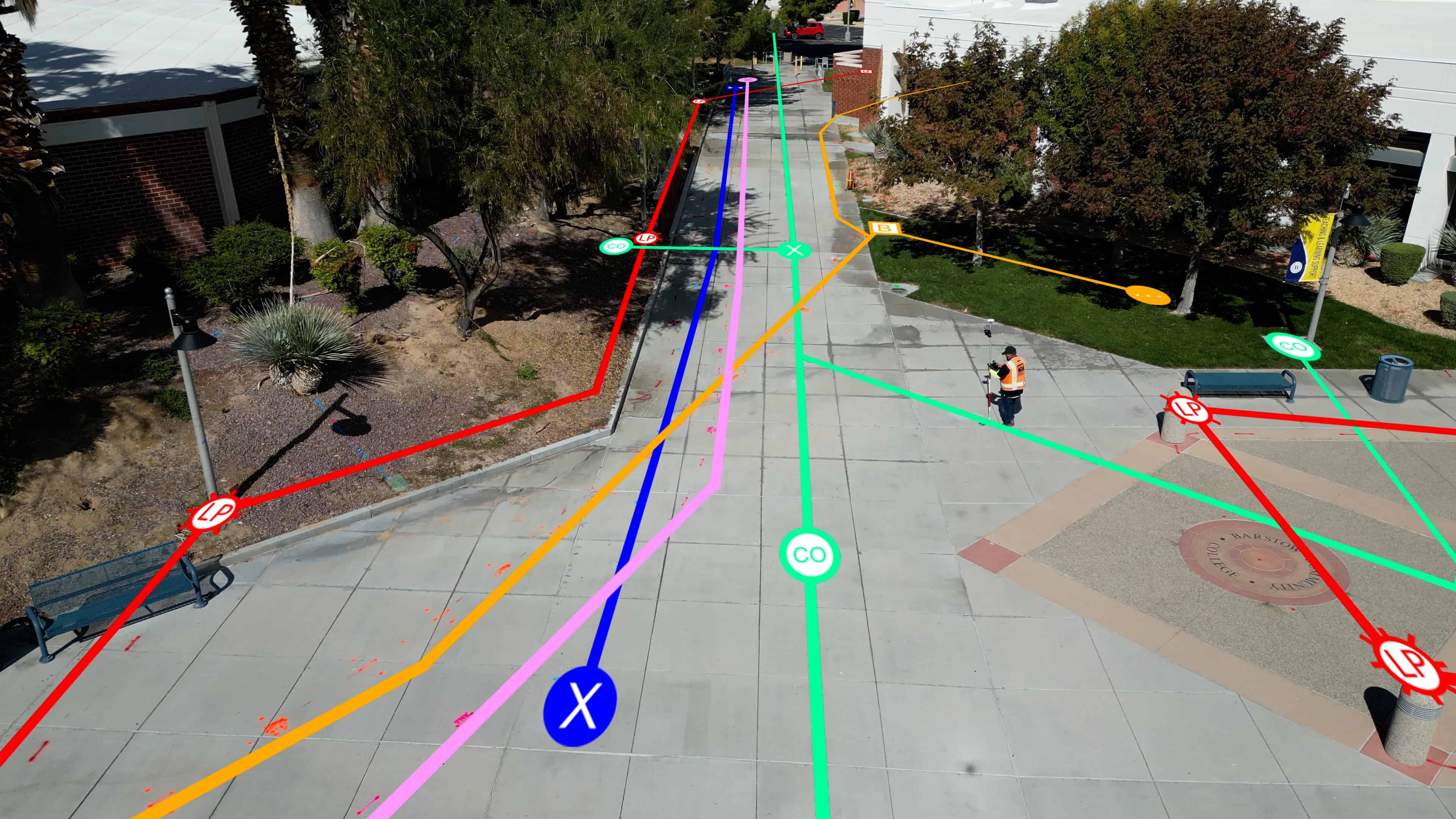
Real life example of our GPRS workers scanning and collecting data.
Advancements in Geospatial Data Collection
With the advent of satellite and drone-based geospatial data collection, the accuracy and breadth of SiteMap’’s utility mapping services are poised for significant improvements. SiteMap® already has many of these technologies, thanks to data provided by GPRS, which uses a breadth of technologies to collect their subsurface data. This includes multiple technologies for utility locating, as well as drone imagery, CCTV pipe inspection, 3D laser scanning, leak detection, and much more.
SiteMap® is more than just a tool – it’s a commitment to a more accessible and efficient construction industry. As we look to meet the demands of our ever-growing urban landscapes, SiteMap® stands out as an innovative force, guiding us through the intricate worlds of construction and subsurface infrastructure.
In embracing SiteMap®, we not only adopt a new technology; we commit to a new standard — a standard where our digital endeavors match the precision of our physical creations. The horizons of construction infrastructure are expanding, and with SiteMap® at the helm, our visions will not just be brighter; they will be accessible, navigable, and achievable. SiteMap® makes seeing simple.
Contact SiteMap® today to learn more about how we can help you visualize your next project.