In the construction and excavation industry, precision and accuracy are vital to the safety of workers, the integrity of structures both below and above ground, and the timely completion of projects. When seeking to ensure that accuracy is upheld, utilizing infrastructure asset management technology is a worthwhile venture.
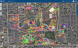
An example of SiteMap’s infrastructure data display
Subsurface as-builts are crucial for accurately representing the many things below the surface. All it takes is one inch of a mistake to obliterate half a block. This means that it’s crucial the data is accurate, easy to access, and easy to understand.
Traditionally, many workers would rely on as-builts to help notate where certain structures and features are settled. Unfortunately, this leads to high risks, and a lot of mistakes. Relying on as builts is a dangerous game of uncertainty, with the consequences being anything from delayed projects to fiery destruction. For subsurface work, this becomes an even greater risk. As such, accurately mapping what’s important (and unimportant) will require extra technology to make it happen. SiteMap® (patent pending) powered by GPRS helps enhance construction efficiency with the use of subsurface as-builts.
The Role of Subsurface As-Builts
Traditionally, as-built drawings provided a visual representation of the final state of a project above the ground. With subsurface as-builts, construction professionals and even government agencies can gain access to a comprehensive and accurate picture of their infrastructure, both above and below ground. The creation of subsurface as builts requires more technology than your standard drawings. This technology includes things like our ground penetrating radar, concrete scanning, 3D laser scanning, and more. All the technologies work together to create one clear, easy to understand image- the subsurface as built. The use of this technology is powering a revolution in construction and utility management, with the benefit of this method being in constant expansion.
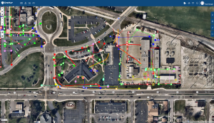
Example of layered subsurface utility data in SiteMap, powered by GPRS
Further, the data provided by these as-builts and therefore GPRS can help facilitate the building of subsurface structural models, which is useful for extending structural interpretations into other areas of limited resolution, as well as use for rapid reservoir appraisal and other potential applications such as seismic processing, well planning, and even borehole stability analysis.
Benefits of Subsurface As-Builts
In a more practical daily use, these as-builts offer easy solutions for your standard construction and utility work. Some of these benefits include:
Accurate Utility Locates
When utility information is misrepresented, the results can be deadly. GPRS utilizes advanced technologies such as GPR, electromagnetic imaging, CCTV pipe inspection, and more to help Intelligently Visualize The Built World ™. With SiteMap® anyone who has ever ordered our services receives a free subscription that allows them to easily access their site data from their favorite device. The data is presented in real –time and is updated often within just five minutes after the completion of the job. This data can be used to help advance, benefit, and secure the methods of subsurface utility engineering. GPRS does not provide SUE, but can support it and help benefit it many ways, such as:
- Preventing unnecessary utility relocations, thanks to accurate depictions, and easy to understand visualizations of utility data.
-
Reducing unexpected conflicts with utilities, knowing the exact location of all utilities is important for safety. This also cuts down on delays caused by redesign, utility damage, and contractor claims.
- Allowing crews to complete their work safely and accurately, cutting down costs, delays, and even fatalities.
Easy Record Keeping
Everyone has lost important papers before, and when it comes to sensitive site data, that loss is much more detrimental. When sensitive data disappears, entire projects may require extensive reworks, which means extra time and resources spent. For some projects, this isn’t safe or possible, creating very real issues and a huge safety risk. Lost infrastructure data causes delays, miscommunication, and could create dangerous situations on site.
SiteMap® gives easy access to all your layered, mapped, and cross-referenced utility information. This information is 99.8% accurate because GPRS Project Managers go through an extensive training process that includes OSHA 10 and OSHA 30 certification, First Aid training, ERail Safe, and countless other trainings to ensure that our Project Managers’ not only get the job done correctly, but safely as well.
GPRS utilizes SIM, which is a standard that focuses on equipment, training, and methodology. SIM requires a professional locating contractor to use multiple locating technologies, to go through more training than is normally required, and to follow an extended checklist that guarantees optimal results. This results in accurate, timely, and efficient data collection which is then visualized and represented in easy-to-understand maps, graphics, and layers accessible to the client through their very own SiteMap®, account. This data remains in the portal, meaning it’s easy to access and never gets lost. This is crucial for accuracy and safe record keeping.
Collaborative Data Management
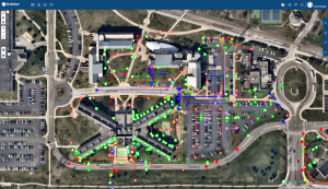
Color-coded, layered utility information, digitally displayed in SiteMap
With SiteMap®, once the comprehensive mapping and modeling work is complete, the data is uploaded to your personal portal, where you and your crew can easily view the data you need the most. This data is collected via multiple means, such as 3D laser scanning, concrete scanning, outdoor and interior utility locating, CCTV video pipe inspection, and even drone imagery. With a SiteMap®, subscription, clients can securely access and share all as– builts and location data, eliminating miscommunication issues while ensuring up-to-date information reaches the right people at the right time. This is a streamlines collaboration that improves overall project efficiency.
An Extra Benefit of Subsurface As-Builts
While subsurface as-builts are excellent for helping construction and utility crews visualize the underground world around them, they’re also useful for teaching and learning purposes as well.
If you’re not in construction, have you ever wondered how we know how far to place our basements in the ground? Or why our houses don’t start to sink in the ground like jagged little headstones, sticking out of the ground begging for savior? Subsurface geology is the study of the physical properties and location of rock and soil found below the surface. With subsurface as-builts, those who study subsurface geology can better understand how man-made and natural subsurface components affect one another. While GPR and EM locating don’t find soil types, they do matter to the effectiveness of the locating process. Most of our geology is performed via soil boring, which an environmental services consultant can provide.
One of the most valuable reasons for learning about the subsurface is understanding the materials below our man-made structures. If we can do this, we can better understand geologic hazards and how to avoid disaster in other ways. We can also better understand where our resources lie, and how we should use them.
In fact, the construction industry relies heavily on mining sand and gravel resources. These provide raw materials needed to produce concrete and asphalt for our roads, homes, and other structures. When we can better understand the amount and the quality of the sand and gravel in a resource deposit, we can influence the decisions of the mining process.

The famous “leaning” tower in Italy might merely be the Pisa tower if engineers and architects could have known what lay underground
This study is more important than what meets the eye and has a real impact on our world. If an actual geologic study was completed in 1360, the Leaning Tower of Pisa, would just be the Tower of Pisa. Construction for the tower began in 1173, and at that time, engineers and architects knew much less about the ground and what was underneath it than we do now. The architects believed that a three-meter foundation would be deep enough, however due to the lack of understanding about the complexity of the soil profile, stability wasn’t achieved in the way they originally calculated.
These studies not only help us build the world around us, but they also are very important for protecting and understanding groundwater aquifers to maintain a steady supply of clean water. Subsurface as- builts help subsurface geographic studies, and in turn help keep the world above the ground healthy and moving.
By using the finest technology available, backed by a passionate and elite team, SiteMap®, powered by GPRS supports geologic studies with accurate subsurface as-builts. This data is crucial for learning about how the world below us affects the world above.
Subsurface as-builts are an important component of underground data, with a wide variety of very important applications such as construction accuracy, safety, highway studies, geographic studies, and more.
SiteMap® can also house comprehensive GPRS data, maps, and models, which produce accurate information that fuels your projects both below and above ground. Without accurate data and subsurface as-builts, construction and utility crews would be putting themselves and their community at a huge risk, while also harming structures and the basic progression of the understanding of the world around us. With quality infrastructure asset management software, you’re able to safely build, cut, core, and dig. Subsurface as-builts help keep your project simple. Make it simple, make it SiteMap®, powered by GPRS.
Contact us today to learn more about how SiteMap® can help your next project.