The role of environmental services and consultants in managing underground utilities when addressing environmental concerns at LUST sites (leaking underground storage tank sites) is of utmost importance. The world beneath our feet is vast and unforgiving, and the smallest error has the potential to endanger communities and the environment for decades.
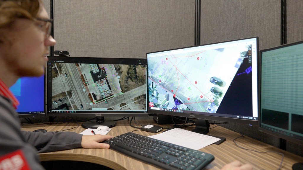
GPRS’ Mapping & Modeling Team can create detailed subsurface maps, and even 3D utility features for CSMs to aid LUST site assessment
Environmental professionals employ advanced techniques and technologies to identify potential hazards, mitigate risk, and remediate contaminated areas. These processes are also crucial to achieving regulatory closure of LUST sites, which are a national concern that many states have begun to place more focus on. SiteMap® (patent pending) recognizes the critical importance of environmental services with a focus on LUST sites, working to help identify, map, and remediate them throughout the nation using advanced technology resources.
By The Numbers
The EPA has done extensive research on LUST sites and what effect they may have on our communities. There are currently some 58,000 open LUST releases, existing in thousands of communities throughout the U.S. – ranging from remote areas to large, urban settings. It’s worth noting that many of these releases are in economically distressed communities, which can cause greater issues, requiring more complicated solutions due to lack of viable resources and pathways.
Approximately 138 million people live within one mile of an open LUST release, which is roughly 41% of the U.S. population. This figure includes approximately:
- 42% of all children in the U.S. under the age of 5
- 50% of all households in the U.S. below the poverty level
When you increase the zone to three miles, 247 million people live within an open LUST release, which is 74% of the U.S. population.
When there is a UST release, it impacts the stakeholders, the community, and the environment.
The consequences of unremediated petrochemical releases impact our communities and the overall environment with unseen subsurface hazards. GPRS, the company behind SiteMap®, takes subsurface infrastructure data seriously and is actively committed to helping expedite investigations of LUST sites, so that they are better understood and closed.
The Impact of Environmental Services & Consultants
While there have been 20 years of progress in closing LUST sites, with some half a million sites achieving regulatory closure, 58,000-62,000 still exist, with the potential to poison our communities and environment. SiteMap® puts environmental professionals in the forefront of enabling the identification and removal of these sites. SiteMap® gives environmental consultants and federal and state regulators the tools they need to speed remediation by Intelligently Visualizing The Built World®, above and below ground. It provides a single source of truth, with GPRS’ 99.8% accurate map of subsurface utility and underground feature data on any site to expedite Phase 1 and Phase 2 studies, which can speed the regulatory closure of LUST sites. SiteMap® can also hold a utility conceptual site model (CSM): a 3D rendering of the subsurface data at the site that allows visualization of preferential pathways for delineation of liquids and may identify potential voids where soil vapor could create additional hazards. GPRS Project Managers help consultants and stakeholders protect the environment and the communities they serve in a variety of ways, with a variety of benefits.
Due Diligence for the Sale of LUST Sites
As part of the due diligence process for real estate transactions, Phase 1 Environmental Site Assessment’s (ESAs) can identify recognized environmental conditions (RECs) associated with the former use of a property. RECs can be associated with LUST sites that weren’t closed properly, among other instances where toxic chemicals may not have been disposed of properly. When Phase 2 ESA work is needed, the safety and protection of the current infrastructure is crucial.
GPRS deploys industry-leading equipment, which is operated by our elite team of 500 nationwide Project Managers. Their Subsurface Investigation Methodology (SIM) process ensures that every possible aspect such as soil boring locations, groundwater monitoring wells, vapor pin locations, and more are cleared of utilities before drilling or dropping vapor pins. The mapping of these underground and encased concrete features is often included in providing due diligence on a LUST site project.
Further, the potential for soil, groundwater, or soil gas contamination may be easily identified with the help of existing maps already in place from the initial investigation. If GPRS provided historical locates prior to the present project, SiteMap® may help the Project Manager provide you with previous sample locations, complete a utility restake, and help determine if any nearby utilities are acting as migration pathways for contamination.
LUST site assessment requires immediate testing. Boring safely requires knowing the location of all underground utilities and features
GPRS is always ready to identify subsurface infrastructure safely and intelligently, creating the utility portion of a process that would allow for the identification and removal of harmful substances and sites, such as LUST sites and their components.
Installing New Utilities on Brownfields/LUST Sites
When new utilities are on the horizon for a brownfield location, it’s important that current zones are mapped and cleared for the process. For zones that have LUST contamination, the discovery and removal of these release sites is crucial, as they may prove detrimental to the new infrastructure. Risks such as water contamination and underground explosion are heightened without proper assessment. This is where SiteMap® comes in, ensuring that each new utility site is properly mapped so you can assess it for contamination or other issues.
GPRS Project Managers can assist environmental consultants to accurately map and zone new areas and brownfields, removing the risk of LUST release complications, among others. Our Project Managers are on site with you as you race the regulatory clock to help get these sites mapped, remediated, and closed.
A Helping Hand
Underground storage tank releases are hazardous to human health and the environment. Once they’re identified, it’s crucial that the process of identification and visualization happens smoothly and quickly to expedite Phase 2 study processes. Once a LUST site has been confirmed, it’s very likely that the soil, groundwater, and soil vapor around the system have already been impacted.
GPRS helps consulting firms perform fieldwork at hundreds of locations across the nation for various reasons. Whether supporting regional buyers and contractors through Phase 1 and Phase 2 processes, or international branded gas owners through the due diligence to regulatory closure, GPRS takes the safety and accuracy of this work seriously.
The faster a consultant can drill, the faster stakeholders and the community can get results
Your Project Manager’s job is to identify and map the underground infrastructure, so that subsurface assessment and mitigation activities can take place sooner than later. This helps to lessen the impact on the community while also helping to remediate the release. GPRS crews use advanced technology such as GPR and EM locating for subsurface utilities, concrete scanning, 3D laser scanning, CCTV pipe inspection, mapping and modeling, advanced photogrammetry, and more to help create a comprehensive, easy to read picture of the world below us. All that information can then be loaded into SiteMap® so that you have secure access to the mapped and layered data you need, anytime, anywhere.
GPRS’ work helps environmental professionals and other workers avoid hitting utilities, avoid shallow conduit strikes, and more. Each utility locating client gets their own complimentary SiteMap® Personal subscription, which gives them access to SiteMap®, including comprehensive and accurate maps, models, and easy to read data. This subscription is easily accessed via your favorite mobile device with the SiteMap® mobile app, or from your computer. With your subscription, you’re able to strip away the data, layer by layer, to help accurately visualize and understand the subsurface components of your site. This data can be securely shared with anyone you choose, and the user interface is so easy, it takes no additional training to understand and utilize your data in real time. Even better, your data is often ready to view within five minutes of project completion.
LUST sites are dangerous to communities and the environment, and they’re more prominent than one would believe. Many states have taken steps to help close LUST sites as they are discovered, which could have a huge impact on the environment as well as the safety of our subsurface world, which has a domino effect on the above ground world as well. SiteMap® is proud to work with environmental professionals and consultants to identify and map subsurface structures and other data that can help the regulatory closure of more LUST sites: improving the safety of some of our most vulnerable communities. With a 99.8% accuracy rating, we’re committed to Intelligently Visualizing The Built World®, one site at a time.
What can we help you visualize? Contact us today to hear more about how our technology and team can help you!