Locating underground utilities – including gas lines, water mains, electric and telecommunication cables, and sewer lines – is critical before excavation or construction. Accurate mapping of this infrastructure ensures jobsite safety, prevents service disruptions, and avoids costly damage.
With SiteMap®, utility locating data becomes more than just marks on the ground – it becomes part of an interactive and centralized software platform for managing infrastructure records and delivering long-term solutions.

By following a thorough utility locating process, construction teams can proceed safely and efficiently without costly or dangerous interruptions.
The Utility Locating Process
A standardized utility locating workflow provides a framework for safe and efficient excavation. The process typically includes:
- Request Existing Utility Records
Obtain as-built drawings and documentation from municipalities, utility companies, engineering firms, or internal records. Reviewing existing maps provides a baseline for known infrastructure, but gaps and inaccuracies are common.
- Perform a Site Survey
Call 811 before any excavation. This free service contacts registered utility owners who mark public utilities. However, 811 does not address privately owned lines, which account for a significant portion of buried infrastructure.
To ensure complete visibility, hire a private utility locating provider to locate and mark non-public lines. Technicians identify unregistered utilities using advanced locating tools and field expertise.
- Select Utility Locating Methods
Specialized tools detect and differentiate various underground assets:
- Ground Penetrating Radar (GPR): Non-destructive radar pulses generate real-time images of subsurface elements, including utilities, voids, conduit, and post-tension cables.
- Electromagnetic (EM) Locators: Detects and traces buried metallic lines such as electrical, telecom, gas, and water infrastructure.
- Acoustic Locators: Analyzes sound waves and vibration to trace pressurized water lines and detect leaks in non-metallic materials.
- Magnetic Locators: Pinpoint ferrous metal infrastructure such as steel pipes, valve boxes, and manhole covers.
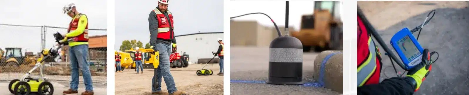
Technicians use specialized equipment to detect and mark underground utilities, such as ground penetrating radar, electromagnetic locators, acoustic locators, and magnetic locators.
- Mark Out Utilities
Utilities are marked on-site with standardized color codes using spray paint, flags, or stakes. Each marking indicates utility type, depth, and alignment using the American Public Works Association (APWA) universal color code:
- Red: Electric
- Orange: Communication
- Yellow: Gas, petroleum
- Green: Sewer and drain
- Blue: Potable water
- Purple: Reclaimed water
- Pink: Temporary survey markings
- White: Proposed excavation
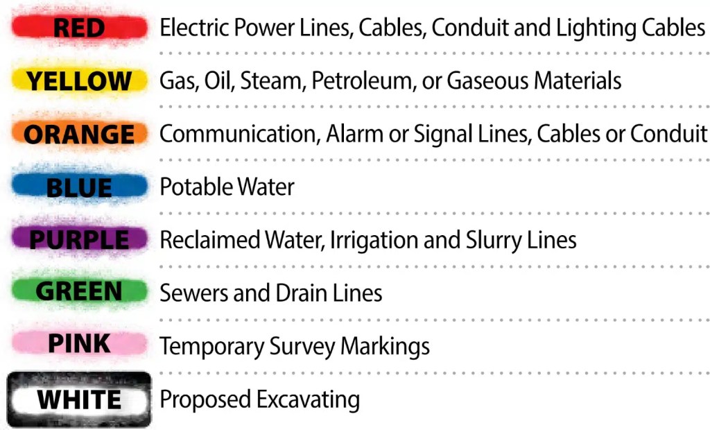
The American Public Works Association recommended color code shall be used to mark the location of underground facilities.
- Verification and Depth Estimation
Technicians may use vacuum excavation (potholing) to verify depth and location. GPR and EM feedback assist in estimating depth prior to digging.
- Map Utilities in CAD, BIM, and GIS
Once marked, utility data is captured for permanent recordkeeping. Coordinates, depths, material types, and conditions are digitally documented and integrated into CAD and BIM systems. The process ensures construction teams are working from accurate, field-verified information – not assumptions.
Data captured in the field is then uploaded into SiteMap, which transforms that data into scalable records stored in a secure, cloud-based software. Deliverables include:
- AutoCAD: For 2D layouts of utilities, with standardized symbology for seamless plan integration.
- Civil 3D: Enables advanced modeling of site elements, ideal for clash detection and pipe network planning.
- MicroStation: Used in DOT and infrastructure projects requiring high precision.
Each utility is georeferenced using GNSS and RTK GPS coordinates. RTK-enabled data achieves centimeter-level accuracy – essential for precise infrastructure documentation. Utility locations captured through SiteMap may differ from satellite imagery, not due to error, but because the software reflects verified geospatial reality.
From Field Data to Digital Records: Why Accuracy Matters
Data quality is the limiting factor in most GIS systems. Inaccurate or incomplete inputs produce unreliable outputs. That’s why SiteMap is built on real-world field data – captured by certified technicians using industry-standard procedures.
All SiteMap data originates from jobsite observations, processed and modeled by trained professionals. Every data point is traceable, consistent, and actionable, forming a single source of truth for construction teams, facility managers, and asset owners.
SiteMap®: The Infrastructure Mapping Software for Verified Utility Data
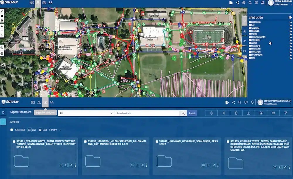
SiteMap is a cloud-based interactive software platform that consolidates utility and facility data into a centralized GIS environment. Built to integrate with your existing systems, SiteMap enables users to visualize subsurface utilities, share project-specific records, and manage infrastructure with confidence.
SiteMap is grounded in accurate, real-world data collected directly from the jobsite by GPRS’ highly trained Project Managers, all of whom are NASSCO and SIM-certified. These insights are converted into 2D and 3D models by GPRS’ in-house Mapping & Modeling Department, ensuring that what you see on screen reflects real field conditions.
What sets SiteMap® apart from other GIS platforms is its foundation: it’s built on accurate data collected directly from the jobsite by GPRS’ highly trained Project Managers, all of whom are NASSCO and SIM-certified.
Why Utility Locating Matters
- Prevents accidental utility strikes and associated repair costs
- Improves excavation safety by identifying hazards like gas and electric lines
- Enhances project timelines by avoiding costly rework
- Ensures regulatory compliance and reduces legal liability
- Establishes permanent digital records for long-term asset management
A thorough locating process – combined with accurate documentation in SiteMap – reduces risk and improves outcomes across the project lifecycle.
SiteMap® Delivers More Than Marks on the Ground
With SiteMap, utility locating becomes part of a broader digital strategy. Clients receive field-verified data integrated into a centralized platform that supports:
- Ongoing infrastructure maintenance
- Planning and design coordination
- Emergency response and repair
- Capital improvement projects
- Asset lifecycle management
GPRS clients receive reliable utility locating services along with real-time data directly in SiteMap. The result is a powerful visual tool that bridges field conditions and office-based design – streamlining workflows from discovery to delivery.
SiteMap is the infrastructure mapping solution that turns subsurface uncertainty into actionable insight.
Intelligently Visualize the Built World®
With SiteMap, you’re not just storing utility data – you’re preserving a verified, centralized infrastructure record that your entire team can rely on. As a secure, cloud-based software platform, SiteMap transforms utility locating results into actionable, digital records – supporting safer excavation, more informed planning, and long-term infrastructure management.
Click below to schedule your live, personal SiteMap demo today!