The field of GIS technology and cloud-based infrastructure management solutions has been continuously growing to meet the unique needs of facility managers and their construction teams. A stand-out leader among the available solutions is SiteMap®, powered by GPRS. This unique digital platform is at the forefront of modern construction, going above and beyond merely providing standard GIS software capabilities. With an all-encompassing, comprehensive service, SiteMap® covers your entire site both above and below ground, with a collaboration-friendly platform. With SiteMap®, users can view their infrastructure in a way that is accurately mapped, digitally organized, and easily accessible.
This innovative technology greatly improves the level of communication, organization, and safety on any project, so facility managers and their teams can collaborate better than ever before. Our services support those striving to Visualize The Built World™ in new ways by providing clear, high-resolution maps and models of any site. SiteMap empowers you to securely communicate your plans with subcontractors, designers, engineers, and others using our lean, streamlined approach.
Our modern technology is built on two key pillars – the Map Viewer and the Digital Plan Room – to ensure you are provided with the digital tools you need to maximize your project’s success. Within the Map Viewer , the process of viewing facility data is simplified by allowing users to connect locational data with specific uploaded documents, models, and specifications. Within this unique feature, facility managers can then easily tag, track, and locationally designate documents so that they are readily available for future reference. Overall, the Map Viewer provides a more fluid experience when sharing and updating as-builts and documenting site upgrades. With these capabilities, the Map Viewer is an essential tool assisting users, saving valuable time and improving communication across a project team. Some unique components of our Map Viewer include…
- Viewable, Searchable Maps
- 3D Modeling Viewer
- Tag Site Features to Maps
- Provide a Preliminary Facility or Multi-Site Measurements
- Calculate Estimates of Length and Area
Our second key pillar is SiteMap’s Digital Plan Room. This feature provides a secure space to upload and share all necessary facility maps, models, photos, reports, and as-builts. These important files can then be directly linked, cross-referenced, and are viewable using the Map Viewer as well. This is achieved by appropriately tagging each document with its corresponding location information. The Digital Plan Room efficiently organizes your most important documents such as…
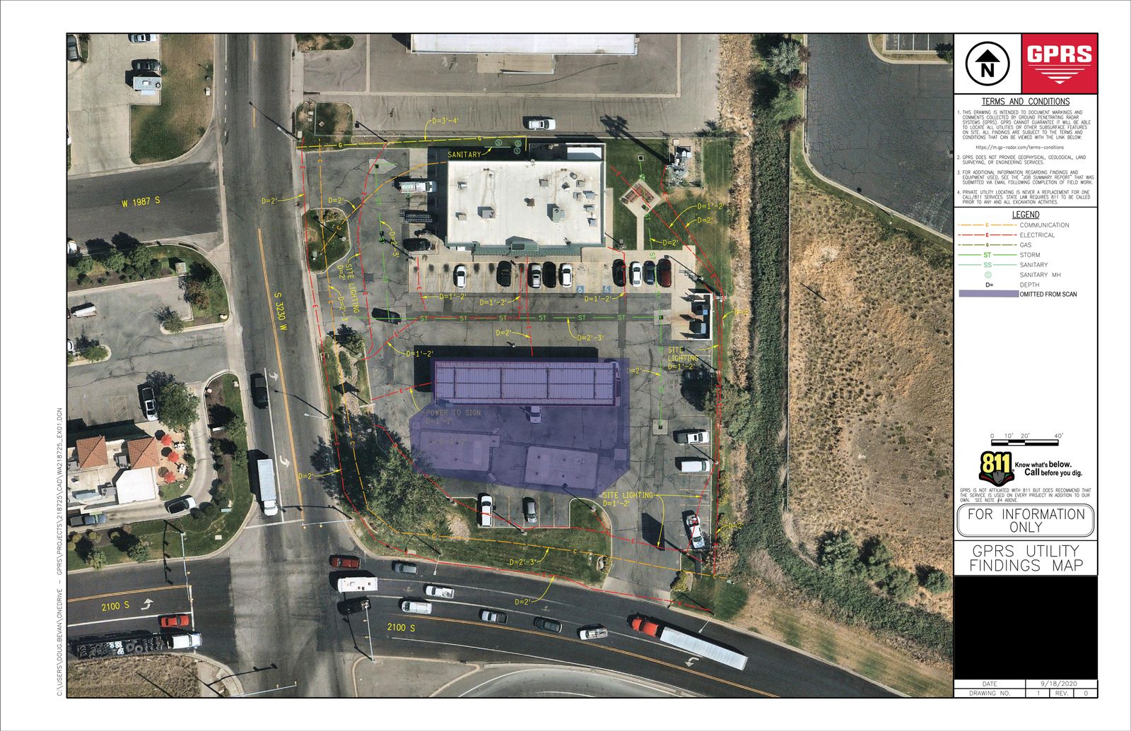
- Underground Utility Locating Data
- Concrete Scanning and Mapping Data
- File Storage For Notes and Specifications
- Historical Drawings
- Site Photos And Annotations
- Drone Footage, Photogrammetry and Orthomosaic Imaging
- Video Pipe Inspection Reports, Photos, and Video
- Water Loss Surveys & Leak Detection Data
- Digitized Blueprints
- Point Clouds & Measurement Data
- Maps & Models
- As-builts of All Varieties
This unique platform was designed to provide customizable support for all kinds of construction projects. For this reason, we have been fortunate enough to work on very exciting projects you might not expect:

The Detroit Tigers reconfigured their home stadium’s outfield walls this past offseason. GPRS Project Managers expertly located and fully mapped water, sewer, electrical lines, and more in the outfield of the stadium in preparation for this project.
Comerica Park MLB Stadium
On January 11, 2023, the Detroit Tigers announced a major project hat would be taking place in their beloved stadium. The goal of this project was to take down the backfield wall of Comerica Park and move it inward by 10 feet, reducing the distance from deep center field to home plate from 422 feet to 412 feet, making the distance to the mound will become 361.5 feet. Pretty simple right? Well, when taking a closer look, this “simple” renovation posed a series of major challenges, especially considering what lays beneath the surface of the wall; conduit, lines, irrigation system, and all other important utilities that makes enjoying a baseball game possible. Prior to any dig, build, or move of this wall, it was crucial that a utility location was properly executed.
Our GPRS Project Managers expertly located and fully mapped water, sewer, electrical lines, and much more. SIM-certified Project Managers are trained to visualize the entire subsurface utility map in their heads as they create it, ensuring that they provide the most thought out models of a given site, and especially how to work around all present obstructions to safely excavate. The comprehensive results of their measurements and field notes are then securely uploaded into the cloud. This process will soon become even more efficient with the launch of SiteMap®, which will allow for a one-click upload so facility managers are instantly provided with a secure and shareable access point for all their facility needs.
In the last year, 75% of higher education campuses and more than 50% of K-12 schools announced plans to begin construction projects, with the overall spend in this space increasing at a steady rate. With this growing demand in mind, the need for safe construction practices is more important than ever before.
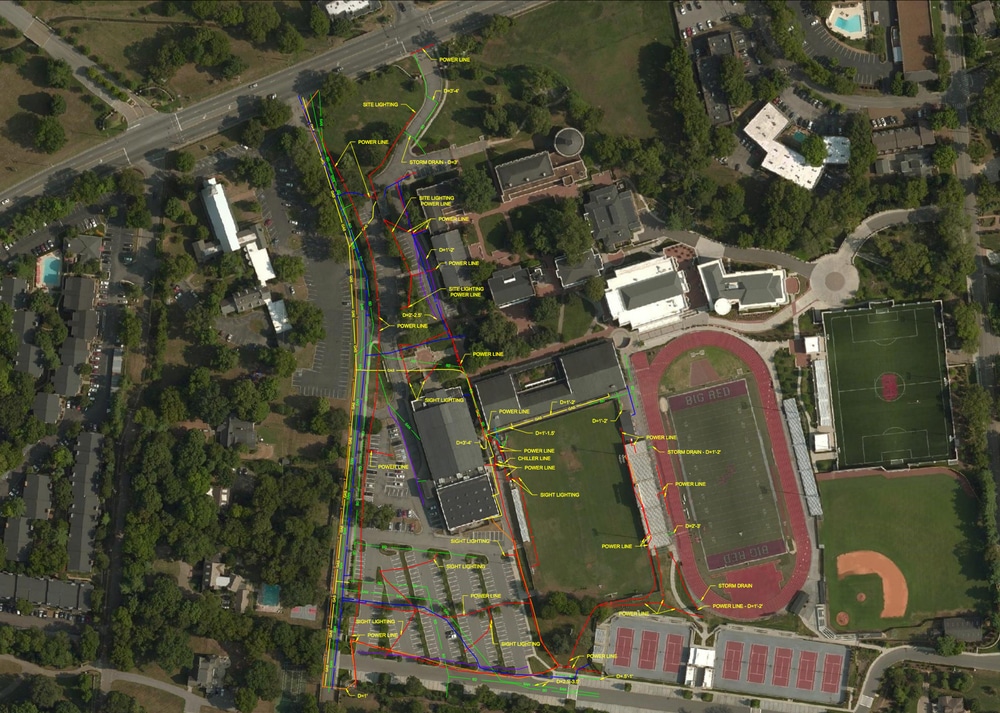
Higher Education and School Campuses
In the last year, 75% of higher education campuses and more than 50% of K-12 schools announced plans to begin construction projects, with the overall spend in this space increasing at a steady rate. With this growing demand in mind, the need for safe construction practices is more important than ever before. A major concern facing contractors on these new educational campus renovation projects are underground private property utilities and concrete reinforcement, as many of these sites are more than one hundred years old and do not have up-to-date as-builts available that can account for the complex grid of hazards likely below the surface.
For cases like these, GPRS Project Managers bring a wealth of institutional knowledge and experience.. With GPRS’ modern capabilities, an accurate and updated locate of underground utilities and clear digging areas can be completed to create a comprehensive subsurface map. In addition to utility locating, ground penetrating radar (GPR) can also be used to scan concrete slabs prior to saw cutting or core drilling to avoid potential hazards. With these trustworthy services, GPRS results paired with SiteMap’s innovative visualization capabilities can help to keep your team and job site safe through better communication and accurate as-builts.
GPRS Project Managers bring a wealth of institutional knowledge and experience.
- Electric Vehicle (EV) Charging Stations
With an unmatched nationwide service network, GPRS makes it easy to take charge of your next project by connecting you with expert Project Managers in your area who can support any project, regardless of its level of complexity. That is why we have partnered with a number of Electric Vehicle (EV) initiatives across the country.
As the demand for electric vehicles increases, the demand for EV charging infrastructure has become more important than ever. When excavating at an existing gas station, restaurant, office building, or other retail establishment to implement these stations, the risk of costly utility strikes is very high. GPRS utility locating services can greatly limit this risk. In addition, SiteMap’s capabilities can provide clear, detailed models of the current job site and the grid complexities it holds so that facility managers can properly plan how to execute their EV project safely and efficiently from the start.
SiteMap® provides a powerful subsurface infrastructure mapping solution for all kinds of construction projects. This modern solution supports facility managers and their teams throughout the entire project process. Because they can store, map, model, and share their facility data in the most efficient way, construction project teams are finally given the digital tools they need to plan and execute projects of any size or complexity. The innovative visualization capabilities of SiteMap® are the solutions needed for those who aim to Visualize the Built WorldTM.
Want to learn more about how you and your team can collaborate better using SiteMap®? Download our brochure, and contact us for a quote today.