Imagine trying to build a house without a blueprint. It’d be nearly impossible, right? As-builts aren’t quite blueprints; you might argue that accurate as-builts are better than blueprints because they capture what actually exists instead of what was intended. Those accurate existing conditions documents streamline many important processes, both in construction and operations & maintenance.
For many different fields, the creation of accurate utility as-builts hold immense importance. These documents serve as comprehensive records detailing the precise locations and specifications of various utilities and infrastructure such as electricity, water, gas, and telecommunications within a given area. Accurate as builts are vital to any project, no matter its ultimate goal. Whether you’re a stakeholder or developer involved in design-build construction, a professional in urban planning, or a project manager in infrastructure management, utility as-builts are a resource you can’t neglect.
What Accurate Utility As-Builts Do for You
1. Accurate Documentation for Future Reference
One of the primary advantages of utility as-built creation is its role in providing accurate documentation for future reference. This is also true when it comes to utility as built creation as well. In the field of construction, projects often span long durations, and having precise records of utility placements ensures that future maintenance, repairs, or expansions can be carried out efficiently. Engineers, architects, and urban planners rely on these as builts to understand existing infrastructure layouts without relying solely on outdated or incomplete blueprints. What’s underneath matters, to your budget, timeline, and safety. That’s why GPRS maintains a 99.8%+ accuracy rate for utility locating & mapping. We can also provide CAD overlays, and even full 3D models of your existing utility conditions, as needed.
2. Enhanced Safety Protocols
Safety is one of the most important aspects in utility maintenance, especially when under construction. Utility as builts play a crucial role in enhancing safety protocols by providing detailed information about underground utilities. This knowledge helps in preventing accidental damage during excavation or construction activities, thereby minimizing risks to workers and the public. Utilities such as gas pipes or high-voltage electric lines can pose significant hazards if not properly identified and handled.
3. Cost Efficiency
Time is money, and delays will happen when there are issues in the plan. By accurately mapping out existing utilities, construction teams can avoid unnecessary delays and expenses caused by accidental utility damage. Change orders, miscommunications, and accidents all cause delays and delays cost money. Accurate as-builts serve as a single source of truth to reduce errors and dial in cost estimates. This proactive approach reduces the likelihood of project interruptions and associated costs, including fines and legal liabilities. Moreover, efficient planning based on reliable as-built data allows for optimized resource allocation and construction scheduling.
4. Streamlined Project Management
Project managers rely on accurate data provided by GPRS to streamline construction processes effectively. Utility as builts provide essential information that aids in project planning and management. With utility as builts, project timelines can be better coordinated, and potential conflicts with existing infrastructure can be identified and resolved early on. This leads to smoother project execution and improved overall efficiency. Accurate measurements mean accurate plans, designs, material orders, and workflows because you’ve already detected potential clashes. Accurate as builts mean that you can execute your project with fewer mistakes, delays, and bottlenecks.
5. Regulatory Compliance
Many jurisdictions require adherence to specific regulations regarding the documentation and protection of utilities during construction or renovation projects. Utility as builts serve as critical evidence of compliance with these regulations. They demonstrate that due diligence has been exercised in understanding and respecting the existing infrastructure landscape, ensuring that projects proceed in accordance with legal requirements.
6. Eliminate Miscommunications
When everyone on your team has access to the same accurate information, it creates a more dynamic and flexible working environment because everyone starts on the same page. Precise as-builts decrease calls, emails, messages, and site visits by providing a single source of truth. With the use of SiteMap® (patent pending), powered by GPRS, everyone on your team is able to stay connected via our easy-to-use platform. SiteMap® holds all of your GPRS-collected data, including your maps, your as-builts, and even your photos and annotations. With SiteMap®, only those who you give access to, will have access to your complimentary SiteMap® account. Communication is made easy when you use SiteMap® to access and share your maps, as-builts, and other important information.
7. Support for Asset Management
Utility providers and asset managers benefit greatly from detailed as-builts that document the lifespan and condition of infrastructure assets. These documents facilitate proactive maintenance planning and asset management strategies. By understanding the location and condition of underground utilities, providers can optimize maintenance schedules, prolong asset lifespans, and ensure reliable service delivery to customers.
8. Integration with Geographic Information Systems (GIS)
Modern utility as-builts are often integrated with GIS platforms, enhancing their usability and accessibility. GIS integration allows for spatial analysis, visualization of utility networks, and seamless data sharing across different departments or organizations. This interoperability improves decision-making processes related to infrastructure planning, maintenance, and emergency response. When you work with GPRS, you’re also given a complimentary personal SiteMap® subscription. SiteMap® is a project & facility management application that provides accurate existing condition documentation to protect your assets and people. Every GPRS utility locating customer receives a complimentary SiteMap® Personal Account. While SiteMap® offers its own system, it is also compatible with many other GIS platforms, allowing you to integrate all of your data in one place, simply.
9. Environmental and Social Impact
Accurate utility as builts contribute to reducing environmental impact by minimizing accidental damage to underground utilities during construction activities. This proactive approach supports sustainability goals by conserving resources and reducing waste associated with repair or replacement of damaged infrastructure. Additionally, reliable utility data helps in minimizing disruptions to communities and businesses, enhancing social sustainability. Further, when you take extra steps to prevent utility hits, you’re also taking extra steps to prevent environmental issues, such as contamination, or issues caused by leaks and water line strikes. When you’re aware of the underground, you’re able to carefully contain any possible consequence and impact.
GPRS As a Solution
As builts are never really “as-built.” They are often “as-intended” because who has the time or money to incorporate every change order, spec, and update? GPRS Intelligently Visualizes The Built World® to give you actual as builts – often accurate within 2-4mm – delivered in a variety of media.
Whether you need accurate utility locates, or a better way to map your world, GPRS has the solutions you need to get your job done safely, on time, and on budget. Our 3D Laser Scanning, reality capture services, and 3D Photogrammetry services can deliver up-to-date and accurate construction as-builts, existing condition drawings, 2D CAD drawings, 3D BIM models, 3D mesh models, digital twins, point clouds, updated floor plans (FLRPLN), and more for construction design, prefabrication, clash detection, facility modifications, and asset management.
Our Mapping & Modeling team are able to provide a variety of solutions, including but not limited to:
Walk Thru 3D
Accurate existing conditions reporting via a 3D virtual tour so you can walk your team through your site to streamline communications and collaboration without excess travel and expense.
Pro Cap Progressive Capture
Capture construction progress, from pre-pour concrete reinforcements to MEP installs, and more to provide accurate timelines and key milestone completions for stakeholders & your team.
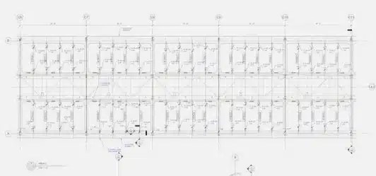
FLRPLN
Turn our 3D photogrammetry virtual tour into an accurate plan view of your project for design, risk mitigation, and emergency planning.
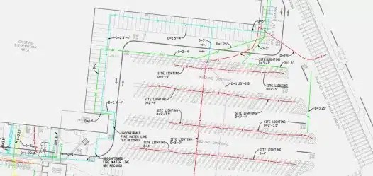
TruBuilt Existing Condition As Builts
Accurate existing condition as-builts with 2D plan views of your above and below ground infrastructure to break down information bottlenecks with comprehensive, layered data.
GPRS is proud to offer multiple types of mapping and documentation and services:
Subsurface Damage Prevention
Existing Conditions Documentation
- Reality Capture
- As-Built Drawings
- Utility Maps
- BIM Models
Construction and Facility Project Management
- GIS Software
- Virtual Tours
- Floorplans
- Progress Document
The benefits of utility as built creation extend across various facets of construction, urban planning, and infrastructure management. From enhancing safety and efficiency to keeping your project on budget and on time, accurate utility documentation plays an important role in modern development, no matter the field. As technology evolves, the importance of comprehensive utility as-builts continues to grow. By investing in the creation and maintenance of these essential documents, professionals and their teams can effectively navigate the complexities of modern construction projects without any guesswork or catastrophe. GPRS is here to help locate and map your facility, both below and aboveground. Offering 99.8% accuracy, the only way you can go wrong is by not calling GPRS to begin with.
Contact us today to learn more about how we can help map the future.