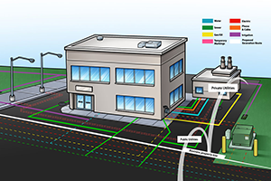
Subsurface utility mapping or underground utility mapping is a crucial process in the construction industry. It involves identifying and locating the location of utility lines, such as water, gas, and sewer lines before any construction work begins. Yet, the process can often be time-consuming and complex, leading to delays in construction projects.
Contractors are always looking for ways to streamline the subsurface utility mapping process to ensure that their projects are efficient and within budget. Let’s discuss a simplified approach that contractors can use to streamline the process and maximize results.
One of the most critical steps in streamlining the mapping of underground utilities is starting with a clear plan.
Start with a clear plan
One of the most critical steps in streamlining the mapping of underground utilities is starting with a clear plan. Before beginning any construction work, it is essential to have a detailed plan in place. This plan should include information on the location of all utility lines. As well as any other underground infrastructure involved. This plan should outline the scope of the project and any possible risks or challenges. With SiteMap® creating a clear plan is simple as all the information you need is in one place.
Creating a clear plan involves a thorough assessment of the project area. SiteMap® uses advanced technology to assess underground utility locations and other subsurface infrastructure. It is important to identify any potential risks or hazards that may impact the project’s success, such as environmental factors or legal restrictions. With SiteMap’s utility mapping app, all this information is available and easy to understand. This information should be in the plan to ensure that all parties involved in the project are aware of the risks and can take the necessary precautions to alleviate them.
SiteMap® is a complete facility visualization and collaboration solution that stores information like detailed, layered utility maps in the cloud. So it is easy for you to securely access and safely share with only those you designate. Starting with a clear plan also means involving all stakeholders from the outset. This includes contractors, engineers, and any other parties involved in the project. SiteMap® allows you to control the data and share it so the right people have the right information when they need it. Clear communication is critical to ensure that everyone understands their roles and responsibilities and that there are no misunderstandings.
By involving all stakeholders in the planning process, everyone has a clear understanding of the project’s goals, timelines, and budgets. This helps to avoid any confusion and ensures that the project is on time, within budget, and to the required standards. Using SiteMap®, everyone will be able to team up with ease. Each team member you give SiteMap® access can log in and see exactly what is happening in real-time.
Use the right tools
The right tools are critical when it comes to streamlining underground utility mapping. One of the most advanced technologies that contractors should invest in is Ground Penetrating Radar (GPR). GPR can locate utility lines and underground structures by transmitting electromagnetic waves into the ground and recording the reflections. This tool can detect non-metallic pipes and cables, making it an ideal tool for contractors who are unsure of the type of underground infrastructure they are dealing with. With SiteMap® GPR is in your toolbox.
Another technology that contractors can use to streamline the subsurface utility mapping process are electromagnetic locators. These devices use an antenna to detect the presence of underground metallic structures, or can be used with a sonde, deployed into pipes on a rodder or on the CCTV camera as part of a Video Pipe Inspection. You can use EM devices in conjunction with GPR to provide a more comprehensive map of underground utilities. Electromagnetic locators can also detect the depth of the utilities, which is vital information for contractors when planning their excavation.
Investing in advanced technologies such as Ground Penetrating Radar and electromagnetic locators with SiteMap®, powered by GPRS, can help you streamline the subsurface utility mapping process. Utility mapping services can locate utility lines and underground infrastructure with great accuracy, providing contractors with vital information to plan their excavation. In fact, GPRS has a 99.8% accuracy rate on over 350,000 jobs. By using the right tools, contractors can reduce the risk of damage to underground utilities and increase productivity, saving time and money.
Partner with experts
Streamlining subsurface utility mapping is easiest when you partner with experts who have advanced training and experience. SiteMap® is a revolutionary underground utility mapping app being offered by industry-leading experts GPRS. GPRS is the nation’s largest company specializing in the detection of underground utilities. Now SiteMap® uses utility mapping services to create a fully functioning facility visualization tool. By using SiteMap®, contractors can save time and money while ensuring that projects are efficient.
Partnering with SiteMap® can help contractors streamline the process in many ways. SiteMap® makes it easy to work with utility companies, municipalities, and other organizations. SiteMap® can help navigate the complex process of mapping underground utilities. They can also help contractors to understand the legal requirements and regulations. This ensures that all work is in compliance with local laws.
Use a digital workflow
Using a digital workflow is another way to streamline the subsurface utility mapping process. A digital workflow means that all information related to the mapping process is digital and stored online in the cloud. This makes it easier to access and share with relevant stakeholders and helps to eliminate errors and reduce delays in the construction process.
In order to put a digital workflow in place, contractors should consider using software and tools designed for this purpose. For example, SiteMap® is an underground utility mapping app that allows contractors to create and manage digital maps of underground utility lines. Anyone involved in the construction process has access to these maps. This ensures that everyone is on the same page and working towards the same goals. Also, digital workflow tools allow for real-time collaboration between contractors and other stakeholders. Again this streamlines the process and reduces errors.
Another benefit of using digital workflow tools like SiteMap® is that they can help contractors to automate many of the manual processes involved in the process. For example, instead of manually measuring and marking the location of utility lines, contractors can use tools like GPR and electromagnetic locators. This is quicker and more accurate for identifying the location of underground infrastructure. This not only saves time but also reduces the risk of errors and mistakes that can lead to costly delays and rework.
A Simplified Approach
By investing in the right software, tools, and expertise, contractors can leverage the power of digital technology to improve the efficiency and accuracy of the process and deliver better results for their clients.
Streamlining the subsurface utility mapping process is critical for contractors looking to be efficient and within budget. By starting with a clear plan, using the right tools, partnering with experts, and implementing a digital workflow, contractors can ensure that the subsurface utility mapping process is quick and accurate. With the help of SiteMap®, all this can be accomplished in one efficient place. SiteMap® is a simplified approach that is revolutionizing the industry. It’s now easier than ever to stay on top of all your projects from beginning to end.
Learn how you can get a complimentary Personal SiteMap® subscription for your next project by talking to your GPRS Business Development Manager or clicking here to schedule service.