SiteMap® helped confirm the accuracy of 811-registered utility mapping and discovered an unmarked stormwater system, ensuring the safety of a trenching project in a California neighborhood.
GPRS Project Manager Darrell Fernandez was dispatched to San Pablo, California, to assist a contractor installing deep well anodes along the line in a residential area.
Deep Well Anodes Explained
Deep well anodes are vertically installed systems designed to safeguard underground structures like pipelines and storage tanks from corrosion. These anodes are embedded in a conductive backfill material deep within a drilled well, where lower electrical resistance layers enhance current distribution. By serving as sacrificial metals, the anodes corrode in place of the protected structures, extending their lifespan.
Connected to a power source, these anodes generate a current that flows toward the buried facilities, effectively preventing their corrosion and ensuring long-term structural integrity.
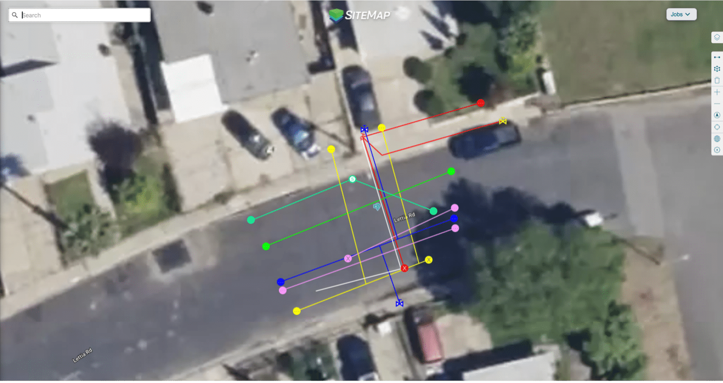
SiteMap® helped confirm the accuracy of 811-registered utility mapping and discovered an unmarked stormwater system, ensuring the safety of a trenching project in a California neighborhood.
What the Client Needed
The contractor in San Pablo had already complied with regulations by contacting the state’s 811 center, which alerted registered utility owners about the planned excavation. This allowed them to provide approximate locations of their underground facilities within the project area.
811 serves as a nationwide, non-profit notification system that connects excavators, contractors, and participating utility companies. Federal law mandates that 811 be informed of any upcoming excavation work so they can notify utility companies, which then dispatch representatives to mark their utilities with flags or paint.
Despite the efforts of the contractor, 811, and the utility owners to ensure a safe excavation, the contractor was aware of an unmarked storm drain system running through the site. None of the partner utilities had fully identified its location, and there was no accurate map or clear understanding of its condition.
Since not all utilities are registered with 811, it is essential to go beyond contacting your local 811 center. Hiring a professional utility locating company like GPRS ensures that all underground infrastructure is accurately mapped and marked before excavation begins.
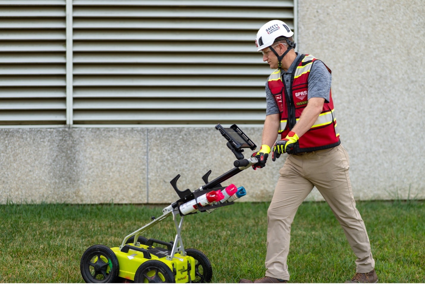
GPRS Project Manager Darrell Fernandez used a ground penetrating radar utility locating cart like this one to locate and map a storm sewer system prior to a contractor installing deep well anodes along a gas distribution line in a residential neighborhood.
How GPRS & SiteMap® Helped Ensure a Safe Project
Normally, GPRS would inspect and map a stormwater system using video pipe inspection—our sewer line assessment service that employs remote-controlled crawlers and push-fed sewer scopes equipped with sondes. These instrument probes allow us to track the devices’ movement while they navigate buried sewer pipes.
This process enables us to simultaneously map underground sewer systems and inspect them for issues such as cross bores, inflow/infiltration, blockages, and structural damage.
On this job, however, the storm drain manholes were clogged at the inlets, preventing access with a crawler or sewer scope.
To overcome this challenge, Fernandez turned to GPRS’ signature technology: ground penetrating radar (GPR).
GPR scanners send radio waves into the ground or solid surfaces like concrete, detecting how these signals interact with subsurface elements such as buried utilities, structural reinforcements, or underground storage tanks (USTs).
Fernandez and his fellow GPRS Project Managers are extensively trained to interpret GPR readouts, identifying the locations of buried objects and estimating their depths. In this residential neighborhood in San Pablo, Fernandez successfully used his GPR unit to locate the stormwater system.
“I ended up seeing an anomaly with GPR, which led straight to the storm drain manhole which was clogged up,” he said. “The anomaly I found went straight through the middle of their work area… [So,] we saved the customer from hitting this storm line, which was in the trench path.”
During his investigation, Fernandez also found several other unknown utilities crossing the intended trench path. Had the contractor hit even one of these lines during trenching, they could have knocked out utilities to the surrounding neighborhood, and saddled themselves with costly utility repairs that would have delayed work and decimated their schedule and budget. And their workers, not to mention the residents of the neighborhood, could have been put in danger.
“The client was pleased that the storm drain and a few unknowns were found,” Fernandez said.
The data Fernandez collected was uploaded into SiteMap® (patent pending), GPRS’ project & facility management application that provides accurate existing conditions documentation to protect your assets and people.
Securely accessible 24/7 from any computer, tablet, or smartphone, SiteMap® is a single source of truth for the vital infrastructure data you and your team needs to plan, design, manage, dig, and ultimately build better. It eliminates the mistakes caused by miscommunications and streamlines the collaboration process for everyone involved in your projects.
The best part: every GPRS customer receives complimentary SiteMap® Personal access with every utility locate.
Click below to schedule a live, personal SiteMap® demo today!