How SIM-Certified Training, Integrated Technology, and SiteMap® Software Deliver Accurate, Interactive Utility Locating Solutions
Subsurface utility investigations play a vital role in enhancing safety and reducing risk during excavation, trenching, and drilling activities. Advanced technologies like ground penetrating radar (GPR) and electromagnetic (EM) locators offer powerful capabilities for detecting buried infrastructure and anomalies. The effectiveness of these tools is greatly enhanced when operated by skilled professionals who follow standardized methodologies.

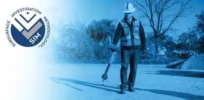
SIM-certified Project Managers use GPR equipment during field training to ensure accurate utility locating.
Untrained use of scanning equipment can result in misinterpretation of data, leading to costly utility strikes. To address this, GPRS developed the Subsurface Investigation Methodology (SIM) – a structured, experience-driven framework that yields consistent, high-accuracy results across all utility locating projects.
What Is SIM?
Subsurface Investigation Methodology (SIM) is a standardized protocol that governs how utility locating professionals conduct scans, interpret data, and deliver results. It is the operational foundation for all GPRS Project Managers and Field Team members, and it underpins the company’s 99.8% accuracy rate across hundreds of thousands of projects.
GPRS’ SIM-certified Project Managers
SIM Comprises Three Foundational Pillars:
- Experience-Based Training
The first and most critical component of SIM is Experience-Based Training, a structured, three-phase program that far exceeds industry standards. While the American Society for Nondestructive Testing (ASNT) recommends just 8 hours of instruction and 60 hours of practice for GPR Level I certification, SIM requires:
- 80 hours of classroom instruction
- 320 hours of mentored fieldwork
The training process includes:
- Pre-Classroom Mentorship: Trainees begin by shadowing SIM-certified Project Managers in the field, gaining firsthand exposure to real-world job conditions and expectations.
- Classroom Instruction: Over two weeks, candidates receive intensive instruction on:
- Standard Operating Procedures (SOP)
- Ground Penetrating Radar (GPR) Principles
- Site Communication Protocols
- Target Mark-Out
- Underground Utility Locating Procedures
- Post-Classroom Mentorship: After classroom training, candidates return to the field to apply their knowledge under supervision. Certification is only granted upon approval from an Area Manager.
Even after certification, Project Managers continue to receive ongoing training in safety, OSHA compliance, and technical updates to stay aligned with evolving industry standards.
- Technological Strategies
The second pillar, Technological Strategies, emphasizes the use of multiple, complementary tools to ensure accuracy and reduce uncertainty in subsurface investigations. SIM mandates the simultaneous use of Ground Penetrating Radar (GPR) and Electromagnetic (EM) locators.
Each technology’s output is used to cross-verify the other, enhancing the reliability of findings. This dual-technology approach is embedded into a unified workflow, ensuring that data is both accurate and actionable.
- Comprehensive Methodology
The final component, Comprehensive Methodology, brings together SIM’s rigorous training and advanced technology into a standardized, repeatable process. This methodology ensures consistency and precision across all project types and environments.
SIM was designed to bring structure and reliability to the unpredictable world of utility locating – ensuring that professionals are thoroughly trained and equipped to deliver accurate results.
By following this methodology, GPRS Project Managers maintain an industry-leading accuracy rate and help ensure that projects are completed safely, on time, and within budget.
Delivering Results Through SiteMap® Software
All utility scan data is captured and stored using SiteMap®, GPRS’ proprietary interactive software platform. SiteMap enables clients to access, manage, and share utility locating records in real time, ensuring transparency and continuity throughout the project lifecycle.
SiteMap extends this functionality to the field, providing 24/7 access to high-accuracy scans on smartphones and tablets. This empowers project teams to make informed decisions based on verified subsurface data.
Why SIM Matters
Despite SIM’s proven effectiveness, the utility locating industry lacks a universal standard. In many cases, individuals with minimal training and access to scanning equipment can offer services without oversight. SIM addresses this gap by establishing a rigorous, enforceable standard that prioritizes safety, accuracy, and professionalism.
By combining expert training, advanced technology, and a robust digital platform like SiteMap, SIM delivers a complete utility locating solution that reduces risk and enhances project outcomes.
Discover how SiteMap centralizes your utility locating data for faster, smarter decision-making. Click below to schedule your live SiteMap demo today!