Would you believe it if we told you that there is currently no true, accurate data for the total amount of miles of utilities that exist underground? In 1994, the National Transportation Safety Board (NTSB) hosted a damage prevention workshop during which Bell Communications Research presented an estimate for total underground utility mileage.
They estimated 20 million miles.
They noted that the mileage was difficult to verify. In 1997, the NTSB produced a Safety Study that they titled “Protecting Public Safety Through Excavation Damage Prevention.” This study continued to rely on that 20 million mile estimate from three years earlier.
In 1999, the Common Ground Alliance issued a report titled, Study of One-Call Systems and Damage Prevention Best Practices, which was initiated by the U.S. Department of Transportation. For this study, over 160 individuals contributed extensively to it. Yet, they again cited the well-accepted 20 million miles of underground utilities.They justified doing so by adding: “This figure has likely dramatically increased in the years since.”
There’s an entire world below your feet, with a complex network of subsurface utilities composed of pipes, cables, and other infrastructure that is vital to our modern lives. Managing this hidden infrastructure is crucial to prevent accidents, to ensure efficient construction, and to protect the communities that live on top of this underground utility jungle. Subsurface utility mapping and management in a comprehensive and efficient manner is a tall order, but not an impossible one. This is where SiteMap® (patent pending) comes in and sets the stage for efficient facility infrastructure management.
The Importance of Infrastructure Management
Figures released by the Pipeline and Hazardous Materials Safety Administration (PHMSA) have stated that since 2005, pipeline operators have reported excavation damage as the cause of 1052 incidents, which resulted in 48 fatalities, 195 injuries requiring hospitalization, and $481,736,551 in property damage. As our energy grid grows and updates to fit the demands it needs to, these instances will become more of a risk as more square footage becomes unmapped.
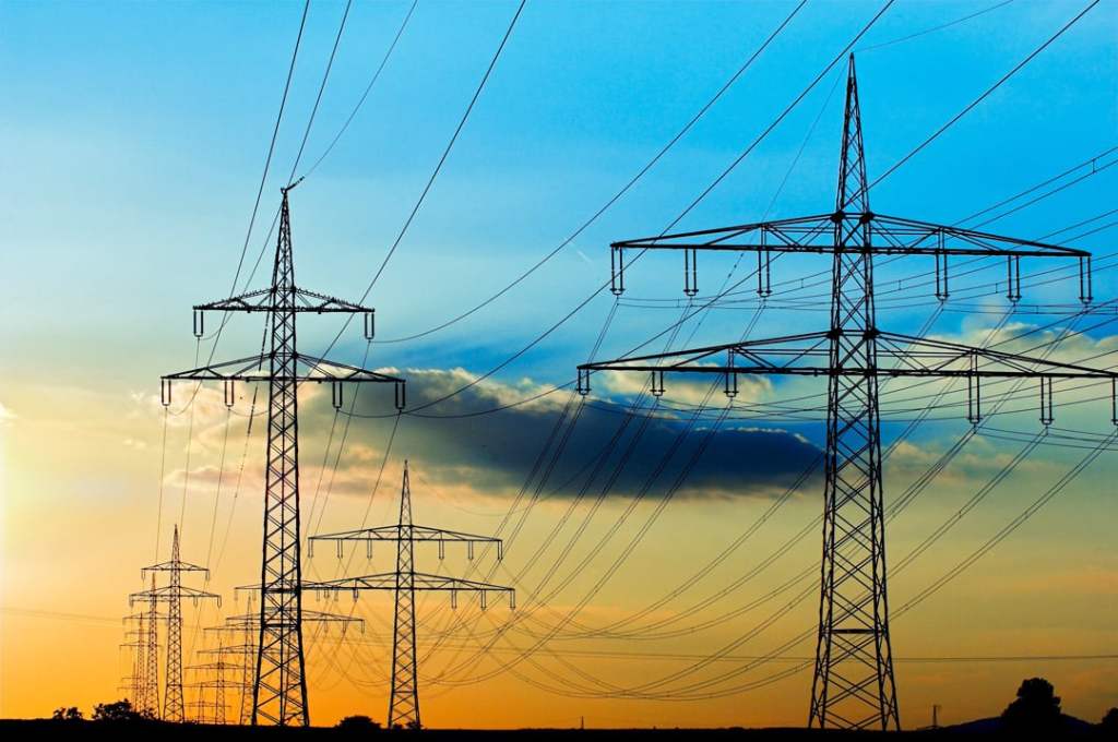
The U.S. power grid is getting a $3.9 million facelift thanks to the Bipartisan Infrastructure Law.
In fall of 2023, the Biden Harris Administration announced that they would invest $3.9 billion into updating the nation’s power grid. This falls under the GRIP program, which is part of the Bipartisan Infrastructure Law. The GRIP program is set to enhance grid flexibility, resilience, and strength against growing threats of extreme weather and climate change. GRIP also supports meaningful community and labor engagement, investing in the American workforce, and advancing diversity, equity, inclusion, and accessibility. This is crucial for our infrastructure and power grid, which has fallen behind in recent years. With the help of technology like those provided by GPRS, this task is at the forefront of preserving our existing infrastructure as well as updating it to support renewables.
The oil and gas pipeline is just as important as our energy grid, as we move forward to safeguard the existing oil & gas pipeline structure, we are met with the challenges of a changing grid with new demands. There are roughly 2.4 million miles of pipes in this infrastructure pipeline, delivering precious utilities to millions of Americans per day. In 2020 alone, these pipes were responsible for delivering 34% of the nation’s gas, and 35% of the nation’s oil. Without the proper technology to maintain, safeguard, and update these systems, America would fail to operate as it needs to. GPRS helps to keep this system safe and operative by properly mapping, tagging, and locating all systems required to not only maintain this infrastructure, but update it as well.
There are numerous studies that support the importance of proper infrastructure detecting, management, and reporting. From the risk to life to the risk of inflated costs, there are plenty of reasons why understanding underground infrastructure is important. When looking to save money, investment in underground infrastructure technology is prominently the smart choice, even according to multiple studies. One of the most recent studies conducted by Pennsylvania State University found $21 in cost saving for every dollar invested in improved location information about underground infrastructure.
Not knowing where underground infrastructure is has engendered the utilities industry, which is estimated to be a multi-billion per year industry in the U.S. worth over $400 billion. The 2022 DIRT report has shared that risks are growing, with 163,726 incidents happening in 2022 alone. There has also been over a 10% increase in damages per construction spending in between 2021-2022. These numbers are showing a trend in the system that is struggling to properly locate, maintain, and update utilities and the maps used to accompany them. Even when infrastructure is located, it’s often improperly managed and is hardly ever appropriately shared. Not only that but it’s often located incorrectly, with even a fraction of an inch of inaccuracy causing a huge risk. SiteMap® reduces risk by giving you instant access and control of your builts and other subsurface data, which is powered by the 99.8% accuracy of GPRS.
SiteMap® and Subsurface Utility Visualization
SiteMap® uses state-of-the-art technology to help manage and visualize your subsurface data, collected by the advanced training and methodology powered by GPRS. The visualization and collection of subsurface data is crucial to increasing the efficiency and quality of locates. In fact, In a survey of 402 locate professionals, better facility maps were given nearly unanimous agreement as a top strategy for improving the efficiency and quality of locates.
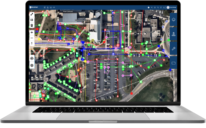
SiteMap® users are able to control how they view and interact with their data.
SiteMap® tries to provide a solution to the lack of true, well-organized, and visualized subsurface data by giving every client who orders services from GPRS a complimentary SiteMap® Personal subscription. Within this subscription, clients are able to access accurate, as-built data that is geolocated, layered, and securely shareable.
SiteMap® users are able to control how they view and interact with their data. They can access updated as-builts to get a comprehensive view of a location before breaking ground. The platform is easy to use, and highly intuitive, shareable from anywhere to whichever device that your team members are most comfortable using.
When your data is all in one place, facility managers and their teams are able to easily share and comprehend what they need to. This helps prevent delays, accidents, and extra costs. By allowing users to interact with their data in such a comprehensive manner, SiteMap® is contributing to a revolution of subsurface utility management.
- Digitally Organized
The Digital Plan Room acts as the ultimate data control center. This is where you can see every file and map on any of your GPRS locating jobs. This data is organized, secured, and layered for the most comprehensive and accurate view. - Access Granted
The Map Viewer allows you to eliminate miscommunication by stripping away the layers that your contractors don’t need, which enables them to see exactly what they need to see, when they need to see it. This viewer is secure, accessible, searchable, and shareable, fostering fluid project management and teamwork.
- Layers of Information
With some SiteMap® subscription levels, all your subsurface infrastructure data can be aggregated, located, and cross-referenced to provide a single source of truth for your team. This reduces risk, damage, and miscommunication. While aggregated historical data is only available in SiteMap® Pro & Team, all other data is easily aggregated and accessible.
- Data Speaks Volumes
As mentioned above, data is crucial for the understanding and development of the world around us. Without a clear understanding of what is happening underneath the surface, we’ll struggle to properly manage the above.
The CGA has made attempts to get a better understanding on just how large the subsurface city below our feet exactly is, and they’ve continuously missed the mark, despite some great efforts.
We’re still lacking on a true answer for just how many miles of subsurface utilities exist below our surface. Some say 20 million miles, some say less, and most agree that it’s really much more.
In 2012, another widely cited figure of 35 million miles was released, originally sourced to the CGA. However, as recently as 2022, the CGA itself continues to use 20 million miles.
The point? We are in tremendous need of accurate reporting and subsurface data management. We only understand small portions of what’s underneath us, and that needs to change.
To break down some more of the other estimates:
- From 1994 to 2018, total gas lines increased from 1,335,530 miles to 1,627,364 miles.
- Between 2001 and 2018, total oil pipeline mileage increased from 158,248 miles to 218,956 miles.
These numbers continue to grow, where the estimated miles of subsurface utilities do not. How can project managers and other professionals rely on current as-builts and other available data if we can’t even get accurate numbers in other ways? What more are we missing?
GPRS and SiteMap® are on a mission to fill in the blanks, in the pursuit of 100% subsurface damage prevention. This begins with accurately locating, and effectively visualizing, mapping, and storing the subsurface data that we collect. The only way to understand how to find a treasure is by following a map, and the only way to understand where the subsurface world lies is to create, follow, and present accurate maps, one client at a time.
A Complete Approach
When a client orders services from GPRS, our elite Project Managers carefully assess and collect data from any given site. Once the job is complete, the data is often available in your SiteMap® account within just five minutes after project completion.
Your SiteMap® account puts you in control by securing your subsurface as-built data in one single source of truth for the life of your project. This data is mapped, layered, and securely shareable 24/7 to anyone you designate, anywhere in the world. You’re given access to your Digital Plan Room, and the intuitive, easy-to-use Map Viewer. Depending on the level of subscription, you may have access to more features, such as aggregated data, continual subscription, historical data, and greater customization and visualization. No matter which level you choose, your SiteMap® subscription is comprehensive, easy to use, and easy to share. Furthermore, it’s powered by GPRS’ unmatched 99.8% accuracy and requires no extra knowledge to understand.
With SiteMap’s intuitive system, anyone is able to understand, use, share, and access crucial information. This means that decisions can be made with more information, sites can be properly worked on, and data is accurately visualized, lowering risks and eliminating delays.
SiteMap® is a comprehensive tool that allows teams to bridge the gaps in their project, providing 99.8% accurate subsurface data in a way that is easy to understand and easy to share. With SiteMap®, users can interact with their subsurface utility maps in a way that helps fuel decisions, protects teams, and increases productivity while lowering risks. The platform is comprehensive and detailed, allowing you to go where you never have before. There is an entire hidden city below your feet, and with SiteMap®, we can practically take you there.