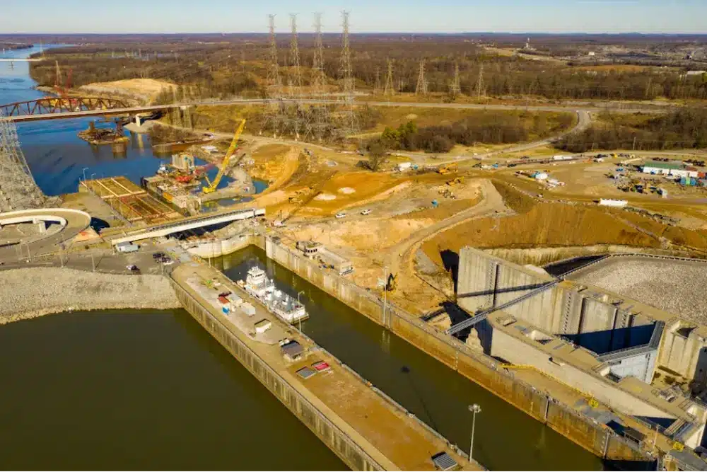
A lock on the Tennessee River that was originally constructed in 1944 is being extended to twice its current length as part of an ongoing expansion effort slated for completion by July 2027.
The Kentucky Lock is undergoing a $1.5 billion modernization that will expand its dimensions to 110 feet by 1,200 feet through the addition of a new chamber beside the existing one. As reported by Engineering News-Record, the current lock will continue to operate once the new structure is finished.
Managed by the U.S. Army Corps of Engineers, the project aims to significantly reduce vessel wait times, which currently average 10 hours – the longest delays among all U.S. locks – by increasing the lock’s capacity.
Central to the construction are 64 structural monoliths that form the backbone of the lock. The first of these was completed in October 2024.
A lock on the Tennessee River that was originally constructed in 1944 is being extended to twice its current length as part of an ongoing expansion effort slated for completion by July 2027.
According to ENR, the 100-acre construction site for the Kentucky Lock Addition includes a concrete batching plant, an extensive conveyor system, and custom-built fabrication shops to produce components for the monoliths.
Thalle Construction Co., a Tully Group subsidiary based in Hillsborough, North Carolina, is responsible for building and installing the remaining structural elements. The Corps estimates the completed lock will generate approximately $114.3 million in annual economic benefits.
Thalle Project Executive Brian Sharp told ENR that each monolith requires around 11,000 cubic yards of concrete to form the lock’s walls. Once finished, the structure will incorporate large valves, culverts, and ports to control water flow between Kentucky Lake and the lock chamber, enabling vessels to travel both upstream and downstream.
“Each monolith is essentially a massive concrete block,” Sharp said. “The monoliths are founded on a prepared bedrock surface and extend to the top of the lock.”
These blocks average 50 ft. in length, 110 ft. in height and vary in width between 75 ft. at the bottom and 25 ft. at the top.
“The monoliths are constructed in five-foot vertical increments and require up to 23 placements to complete,” Sharp says. “These five foot heights are referred to as lifts and represent individual concrete placements.”
Kenneth Bowen, project executive at Thalle, notes that, “altogether, the 51 monoliths needed to complete the downstream portion of the lock within our scope involve more than 1,200 separate concrete placements.”
Beyond the concrete, each monolith is reinforced with steel and incorporates numerous embedded fabricated metal components, including wall armor, line hooks, floating mooring bits, and internal features such as culvert liners, valves, and mechanical systems essential for operating the massive miter gates.
Thalle’s involvement with the lock began in 2010, following a contract award for site excavation, construction of nine upstream monoliths, and installation of the upstream miter gates. That initial phase concluded in 2016, and the company was awarded the current phase of work in 2021.
Bowen told ENR that ensuring each monolith is on stable ground has been a challenge throughout the Kentucky Lock project.
“Construction of each monolith starts at the foundation, where rock is blasted to a consistent elevation that is inspected and deemed competent to support the massive structure,” he said.
Many of the foundations demand thorough preparation, which involves rock cleaning, dental excavation, and filling surface irregularities with dental concrete before placing a concrete mud mat to finalize the foundation work.
In situations where subsurface geotechnical analysis indicates the need for further reinforcement, Thalle drills as deep as 60 feet into the bedrock and installs steel shafts encased in concrete to enhance structural support, Bowen explained.
How Accurate Infrastructure Mapping Protects Your Infrastructure Projects
The Kentucky Lock project plays a vital role in the broader national effort to modernize America’s inland waterway infrastructure, which earned a C- grade in the American Society of Civil Engineers’ (ASCE) 2025 Report Card for America’s Infrastructure.
In that assessment, the ASCE described inland waterways as the “hidden backbone of the nation’s freight network,” highlighting that they facilitate the movement of $158 billion in goods each year.
“Inland waterways allow commodities to move cost-effectively, reducing the strain on congested roadways and rail systems, and with fewer greenhouse gas emissions,” the ASCE wrote. “Federal funding has increased in recent years, but a $7.5 billion backlog for construction projects remains, causing ongoing lock closures.”
While the C- rating marks a modest improvement from the D+ given in the previous report, the system still faces significant challenges:
– Roughly 80% of the nation’s lock and dam infrastructure has surpassed its intended 50-year lifespan
– The aging and limited capacity of these structures contribute to average vessel delays of nearly three hours
– Unpredictable water levels and drought conditions further complicate navigation, especially for large vessels like barges, which often must carry lighter loads to avoid grounding in shallow areas
Whether on water or land, GPRS supports the safe and efficient completion of infrastructure projects big and small with our comprehensive suite of subsurface damage prevention, existing conditions documentation, and construction & facilities project management services.
Utilizing state-of-the-art technology like ground penetrating radar (GPR), electromagnetic (EM) locating, 3D laser scanners, and remote-controlled sewer pipe inspection crawlers, we provide you with comprehensive above and belowground infrastructure data to help you plan, design, and build better.
All this accurate, field-verified data is always at your fingertips thanks to SiteMap® (patent pending), GPRS’ intuitive and interactive infrastructure mapping software platform. Accessible 24/7 from any computer, tablet or smartphone, SiteMap® is a single source of truth for the infrastructure information you need to plan, design, and build better.
Click below to schedule a live, personal and free SiteMap demo today!