Imagine trying to complete a complex brain surgery with your eyes closed. You have no idea which neuron lies where, and your only advanced knowledge is what you learned in medical school. You can see a general map in your head of the brain, but it’s not translating that well, and one wrong snip could mean certain death. While this would never happen, similar situations happen every single day in the field of construction, as well as in countless other industries. The U.S. has millions of miles of utilities below our feet, most are accurately mapped, and many records are completely outdated.
Accurate knowledge of subsurface utilities is critical for success. The integration of Building Information Modeling (BIM) with subsurface utility locating is revolutionizing how stakeholders, project managers, and other important workers manage challenges and the process of construction with safety and utility security in mind. SiteMap® (patent pending), powered by GPRS, is a comprehensive way to see the subsurface in a new way. But how do platforms like SiteMap®, and BIM help enhance construction safety and efficiency?

Understanding Subsurface Utility Locating
Subsurface utility locating utilizes various technologies to detect and map underground utilities such as water pipes, electrical cables, and telecommunications infrastructure. Accurate mapping of these utilities is crucial during planning, design, construction, and maintenance phases to prevent damage, ensure safety, and minimize disruptions.
Utility detection is critical to any project where subsurface excavation is planned. This is crucial to ensure success and avoid utility strikes. To achieve a comprehensive, safe utility locate, a private utility locating company must be utilized to mark & map buried facilities on private property. GPRS is able to detect both private and public utilities with 99.8% accuracy. Professional utility locators with proper training, multiple technologies, and field-tested methodology are essential to properly locating all site utilities. GPRS offers all of that, and then more.
GPRS offers a comprehensive list of services, such as:
Private Utility Locating Services
65% of all on-site utilities for virtually any construction project or facility are private. This means that very useful 811 One Call services cannot locate them for you. GPRS provides comprehensive digital and PDF utility maps of every utility on site, whether the utility is public or private. These maps include comprehensive and complete levels of data, including depths. What’s more, you can export your utility data into a wide variety of drawings, maps, and models that provide seamless communication and collaboration on any project.
Facility Mapping Services
GPRS’ mission is to Intelligently Visualize The Built World®. We provide comprehensive above and below ground facility and infrastructure mapping for the construction, facility management, engineering, architecture, manufacturing, and related industries. Our services provide accurate 3D BIM models, 99.8% accurate utility locating & concrete imaging via GPR, NASSCO-certified Video Pipe Inspection (CCTV) reports, 2D CAD drawings via FLRPLN, Conceptual Site Models (CSM), rectified 3D photogrammetry via ProCap & 3D virtual tours via WalkThru 3D.
Environmental Due Diligence & CSM
GPRS provides assistance in Phase I and Phase II Environmental Site Assessments (ESAs), whether for due diligence before a sale or when tracking potential contamination for regulatory concerns. We provide accurate utility locates that map preferential pathways for contaminants and can provide detailed, 99.8% accurate conceptual site models (CSM) for 3D site visualization.
UST Locating
Abandoned tanks and lines can be easily found and comprehensively mapped by our SIM-certified Project Managers, and our Mapping & Modeling team can create a comprehensive map and/or conceptual site model (CSM) of your facilities for risk mitigation and recording purposes.
Utility As-Built Creation
GPRS provides a complimentary PDF, .KMZ file, and a SiteMap® Personal subscription with every outdoor utility locate. Our Project Managers utilize the data from your utility field markings to create digital, layered utility maps inside SiteMap®, and our in-house Mapping & Modeling Team can provide you with TruBuilt plan views and even a comprehensive 3D BIM or Conceptual Site Model (CSM) that accurately visualizes your entire utility infrastructure to communicate, collaborate, and manage your project or facility better.
GPRS has a service for almost any utility locating need, including:
- Soil Boring Clearance
- Video Pipe Inspection
- 3D Laser Scanning
- Concrete Scanning
- Virtual Tours
- Drone Imagery
And much more.
Understanding BIM
BIM has technically been around since the 1970s, however, it wasn’t until sometime in the 1990s that gained popularity. Chuck Eastman, who is a professor at Georgia Tech, is often credited with developing the first BIM software. Since its conception, BIM has become an essential tool in the AEC (Architecture, Engineering, and Construction) industry. BIM allows for processes to run smoothly, and for collaborations to be more fruitful.
Multiple countries and regions have started to promote the implementation of BIM in the AEC sector. In fact, the UK Government Construction Strategy (GCS) has required 3D BIM to be used in full collaborations as a minimum requirement for all construction projects since April 2016. BIM has even been used in efforts to reduce waste during construction, as well as many other beneficial practices.
Much like twins, BIM and CAD are often used interchangeably. However, they’re far from the same. CAD is primarily a 2D drafting tool, while BIM is a 3D modeling tool that includes extras like geometric and semantic data, this data includes things like building element types and material properties. BIM takes the design process a step further by allowing professionals to collaborate in real-time and making changes to the model as needed, when it’s needed.
BIM software also has some extra abilities, and due to the data being interlinked, offers abilities like quantity assessments, collision checks, and the ability to generate simulation models or construction plans. This allows for better planning and scheduling. BIM is also used to detect clashes between components, which helps with reducing the likelihood of errors during construction. While CAD creates 2- or 3-dimensional drawings that don’t distinguish between their elements, BIM is able to incorporate 4-D (time) and 5-D (costs). BIM helps users get a realistic view of what could be. Projects modeled in BIM can include the real products and materials that will be used to build them. Users are able to incorporate their geometry, characteristics and even their cost into the model. Users can also embed contact information to acquire them once approval has been granted.
There are vast libraries of products, allowing users to easily download aspects that can be used in their projects. BIM takes architectural design, and makes it easier to manage, giving a realistic view and a smoother process.
The Role of Building Information Modeling (BIM)
BIM is a collaborative process that uses digital representations of physical and functional characteristics of a facility or project to improve planning, design, construction, and operation. It enables professionals to visualize the entire project lifecycle in a virtual environment, right down to potential costs.
There is a startling lack of collaboration between professionals in the AEC sector. The National Institute of Standards and Testing, in a recent study, estimates that this lack of interoperability costs building owners $15.8 billion annually. With BIM, users can detect MEP, whether internal or external, clashes before construction begins. This helps reduce delays, as well as last-minute changes, and even the amount of rework that will be required.
BIM offers a league of benefits to the construction industry, especially when paired with subsurface utility locating, which takes the guesswork out of the subsurface and instead translates it into part of a workable model.
Benefits of Integrating BIM with Subsurface Utility Locating
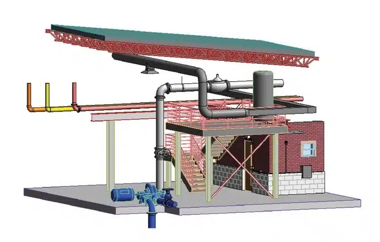
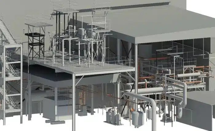
1. Accurate 3D Visualization and Clash Detection
BIM allows for the creation of detailed 3D models that incorporate subsurface utility data obtained through technologies like Ground Penetrating Radar (GPR) and Electromagnetic Locating (EML). GPRS offers a 99.8% accuracy rating across over 400,000 locate jobs nationwide. When combined with such high accuracy, these models provide a comprehensive view of both above-ground and underground components.
Visualization: Users can visualize spatial relationships between surface features, buildings, and subsurface utilities. This visualization aids in decision-making during design phases.
Clash Detection: By overlaying utility data onto BIM models, potential clashes between planned construction elements and existing utilities can be identified early. This reduces conflicts during construction and minimizes costly redesigns.
2. Improved Coordination and Collaboration
BIM facilitates enhanced coordination and collaboration among project stakeholders, project managers, and anyone else involved:
Data Sharing: Centralized BIM models serve as repositories for project-related information, including subsurface utility data. This ensures all stakeholders have access to updated information, fostering transparency and reducing misunderstandings. With GPRS, all data, maps, and models are quickly delivered via file sharing platforms and our new infrastructure data platform, SiteMap®.
Virtual Design Reviews: Virtual walkthroughs and design reviews enable stakeholders to identify and address potential issues before construction begins. Discussions focus on optimizing utility placements to minimize conflicts and streamline installation.
3. Enhanced Project Planning and Risk Management
Integration of BIM with subsurface utility locating improves project planning and risk management:
Early Risk Identification: BIM simulations help identify and mitigate risks associated with subsurface utilities. Project teams develop contingency plans for handling unexpected utility discoveries without disrupting timelines.
Cost Savings: By minimizing costly redesigns and construction delays, BIM integration contributes to overall cost savings throughout the project lifecycle. BIM, especially when paired with accurate utility locating, helps reduce the likelihood of a utility strike, or other catastrophic occurrence caused by improperly mapped or represented utilities.
4. Lifecycle Management and Maintenance
BIM supports facility management and maintenance by providing accurate as-built information:
As-Built Documentation: BIM models updated with actual installation details of utilities serve as valuable as-built documentation. This aids in future renovations, upgrades, and maintenance activities. GPRS Intelligently Visualizes The Built World® to give you actual as-builts – often accurate within 2-4mm – delivered in a variety of media. Our Mapping & Modeling Team can create anything from a simple GPS-enabled locating map of your utility locate, to highly detailed 2D CAD drawings and 3D BIM models, depending on your needs.
Asset Management: Facility managers leverage BIM for efficient asset management, scheduling preventive maintenance, and optimizing operational efficiency.
Future Trends and Technologies
As BIM has evolved over the last 30-50 years, its expected to continue, especially in relation to subsurface utility locating and the field of construction. Integration of BIM with subsurface utility locating is expected to evolve further:
AI and Machine Learning: AI-driven algorithms enhance utility detection accuracy and automate data processing from various sensors.
Augmented Reality (AR) and Virtual Reality (VR): AR and VR technologies may enable real-time visualization of subsurface utilities during field operations, enhancing onsite decision-making and safety.
Integration of Building Information Modeling with subsurface utility locating opens up new views that have never been seen before. The conjoinment of these two services creates a powerhouse of accuracy and visualization that goes beyond CAD, traditional mapping, and even your standard 3D model. By leveraging digital technologies and collaborative workflows, those involved can achieve greater efficiency, minimize risks, and deliver projects on time and within budget.
Embracing this ultimate synergy allows construction professionals to effectively manage and optimize the complexities of subsurface utilities, paving the road for safer, more efficient construction projects in the future. GPRS’ elite team of Project Managers and professionals is here to help take your construction project a step further, through the marriage of accurate utility data and BIM.
See the world, build the world, change the world. Contact GPRS today.