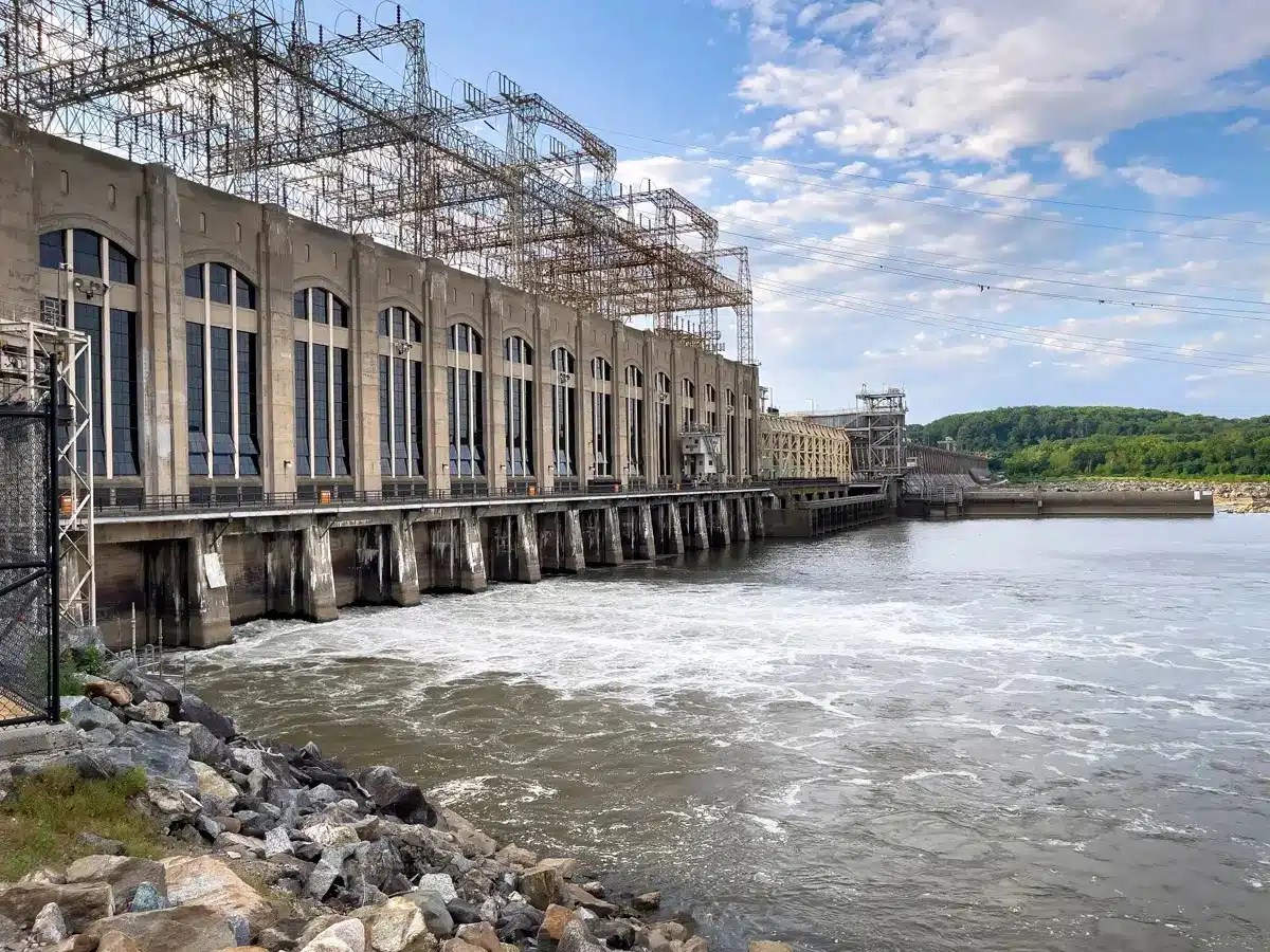
The Susquehanna River is about 444 miles long, stretching throughout the Eastern Seaboard. The river has been crucial historically, supplying needed resources for local coal mines, and recently, supplying hydroelectric power. Travelers make their way over the many bridges and passes over various parts of the river in different areas of Pennsylvania and the surrounding area. There is now a project underway meant to help tie together areas along the river with a new highway bypass, U.S. Route 15. This project hasn’t been an overnight success, however. It’s taken more than 50 years of planning, and a lot of new technology to make it happen.
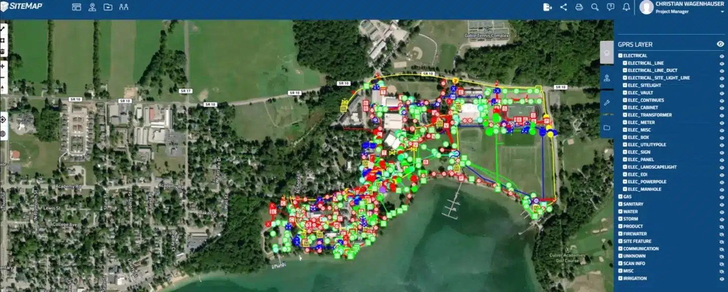
One type of technology that will likely be used is a centralized GIS platform for project data, like SiteMap® (patent pending), powered by GPRS. Cloud-based GIS platforms often play a pivotal role in the successful completion of large projects like the Central Susquehanna Valley Transportation (CSVT) project. But how do SiteMap® and similar technologies aid in the efficient and safe progression of such massive undertakings?
Central Susquehanna Valley Transportation Project: An Overview
The Central Susquehanna Valley Transportation Project has been a long-awaited initiative aimed at improving traffic flow and safety in the region. This project, divided into northern and southern sections, has been in progress for several decades. It is designed to create a bypass around the congested areas of Northumberland and Lewisburg, ultimately connecting key transportation routes and enhancing regional mobility. “It’s a four-lane limited-access new roadway that connects Route 147 in Northumberland County to Routes 11 and 15 in Snyder County,” PennDOT’s Eric High said.
The thirteen-mile thruway project has been in the works for decades, but due to funding issues, construction only started in 2015. The project is being completed in two phases. The northern section will connect Route 147 in Northumberland County to Route 15 in Union County. The southern section will be another way to connect Route 15 to Selinsgrove. While the northern section is now open to traffic, the southern section is expected to be completed in 2027.
The significance of this project shouldn’t be overstated, especially since this project has been in the making for over fifty years, highlighting its importance and the challenges faced in bringing it to fruition.
The construction of this vital link involved intricate planning, extensive coordination, and the integration of advanced technologies to overcome the numerous hurdles encountered along the way.
The Role of Technology in Modern Infrastructure Projects
In the past, infrastructure projects were often littered with delays, cost overruns, and unforeseen complications. However, the advent of digital and advanced technologies has revolutionized the way these projects are executed. One good example of such technology that is helping to shape the future of project management, especially when subsurface utility locating is involved, is SiteMap®. SiteMap® is an advanced underground utility mapping software, powered by the amazing values, elite training, and 99.8%proven accuracy of GPRS. SiteMap® offers an interactive underground utility map of your area, providing precise and easy to access data that is crucial for the successful execution of large-scale construction projects.
The awe-inspiring technologies of the Fourth Industrial Revolution are changing the possibilities for the built environment. Advances in data proliferation, connectivity, automation and sustainability technology are shaking up existing markets and creating new ones altogether. The way we manage infrastructure projects, from energy to data collection, is rapidly changing. GPRS and SiteMap® are just two crucial examples of what modern technologies can do to help change and serve infrastructure projects.
Understanding SiteMap® and Its Benefits
Our GIS software platform, SiteMap® allows you to quickly access, view, and share your infrastructure data securely with subcontractors, engineers, and your team. All of your utility, structural, water & sewer, and facility information is uploaded into the SiteMap® Map Viewer and Digital Plan Room.SiteMap® is a digital utility mapping tool that leverages cutting-edge technology to provide detailed insights into underground utilities. This tool is particularly beneficial for infrastructure projects as it helps in identifying and mapping the complex network of utilities that lie beneath the surface. By offering a comprehensive and interactive underground utility map, SiteMap® ensures that project planners and engineers have access to accurate information, reducing the risk of unexpected encounters with underground utilities.
SiteMap® offers users a convenient way to experience facility and location data. Additionally, this geospatial solution functions as a digital storage platform for blueprints, as-built drawings, maintenance records, permits, and more. SiteMap® can visualize georeferenced utility data, site photos and videos, BIM Models, and CAD files all in one platform. Because data portability matters, SiteMap® has been designed to offer seamless portability into other popular GIS platforms, so you can get the assurance of GPRS’ 99.8%+ accurate utility maps and concrete scans inside your favorite GIS software. A SiteMap® Personal subscription is free for GPRS customers and also has available subscription tiers for different construction and facility needs. SiteMap® shows data in a customizable, intuitive, affordable platform that updates data in minutes.
How Can SiteMap® Improve Project Outcomes?
Enhanced Safety: One of the primary concerns in any construction project is safety. Accidentally striking underground utilities can lead to hazardous situations, delays, injuries, fatalities, and increased costs. SiteMap® mitigates this risk by providing detailed maps of underground (or even above ground) utilities, allowing construction teams to plan their activities more effectively and avoid potential hazards. In 2022, the United States construction industry had the highest number of fatal work-related accidents resulting in 1,092 deaths. Platforms like SiteMap®, powered by our elite team of Project Managers, CAD designers, and more at GPRS are helping to reduce this risk through accurate and accessible site data.
Improved Efficiency: With accurate digital utility mapping, construction projects can proceed more efficiently. SiteMap® eliminates the need for time-consuming processes that often result in delays and accidents. By streamlining the process of identifying and mapping underground utilities, SiteMap® helps in reducing project timelines and costs.
Informed Decision-Making: Access to real-time data through SiteMap® empowers project managers and engineers to make well-rounded, informed decisions. They can assess the feasibility of various construction activities, plan alternative routes if necessary, and address potential issues before they escalate. This proactive approach significantly enhances the overall project management process.
Cost Savings: Unforeseen utility encounters can lead to substantial financial setbacks. By utilizing SiteMap’s underground utility mapping software, construction projects can avoid unnecessary expenses associated with utility damage and project delays. This cost-effective approach ensures that projects stay within budget and are completed on time.0
How Technology Like SiteMap® Impacts Projects Like This
This Pennsylvania project is a prime example of how SiteMap® and similar technologies are transforming the landscape of infrastructure development. The integration of advanced mapping technologies has likely played a crucial role in the smooth execution of this project. Developers are able to carefully plan and map areas near, or even over the river, with great accuracy. As-builts can help guide the project, supplying crucial information and examples that can change with the project. Advanced mapping and modeling, subsurface mapping and utility locating, as well as technologies like 3D laser scanning, and more have all been used in similar projects, as well as this massive highway overturn itself.
Technology like this helps projects such as this one long-time in the making, it helps in various ways such as:
- Pre-Construction Planning
Before breaking ground, comprehensive pre-construction planning is essential. SiteMap’s digital utility mapping capabilities enable project planners to gain a clear understanding of the underground, or above ground landscape. Our elite Mapping and Modeling Team is able to create everything from BIM models, to point clouds, to virtual walkthroughs, as-builts, aggregated maps, and more. This visualized information is invaluable in identifying potential challenges and devising strategies to address them. For instance, if an underground utility line is discovered in the proposed construction path, the project team can modify the design to avoid conflicts, ensuring a smoother construction process.
- Easy Data Integration
During the construction phase, easy and accessible integration is crucial for maintaining project momentum. SiteMap’s interactive underground utility map provides easy to understand visualizations and data regarding utility locations, as well as any other area that was mapped and surveyed. This data allows construction teams to adjust their activities accordingly. This dynamic approach minimizes disruptions and ensures that the project stays on track.
- Coordination with Stakeholders
Infrastructure projects often involve multiple stakeholders, including utility companies, government agencies, and local communities. Effective coordination among these stakeholders is essential for project success. SiteMap® facilitates seamless communication and collaboration by providing a centralized platform for sharing utility information. This transparency fosters better coordination and minimizes the risk of misunderstandings or conflicts.
- Minimizing Environmental Impact
In addition to safety and efficiency, minimizing environmental impact is a key consideration in modern infrastructure projects. SiteMap’s precise utility mapping helps in avoiding unnecessary excavation and disturbance of the surrounding environment. By reducing the project’s footprint and minimizing disruptions to natural habitats, SiteMap® contributes to more sustainable construction practices.
The Future of Infrastructure Development with SiteMap®
As infrastructure projects continue to grow in complexity and scale, the role of advanced technologies like SiteMap® will become increasingly vital. Applied to this Pennsylvania project, just one example of how digital utility mapping can help transform the construction landscape becomes evident. The benefits of enhanced safety, improved efficiency, informed decision-making, and cost savings make platforms like SiteMap® an indispensable tool for modern infrastructure development.
The integration of SiteMap® and similar technologies is expected to become standard practice in the industry. The ability to accurately map and manage all utilities, including other subsurface and aboveground facilities, will not only streamline construction processes but also contribute to more sustainable and environmentally responsible practices, which is becoming more crucial as time goes on. Additionally, as these technologies continue to change, adapt, and evolve, we can anticipate even more sophisticated features and capabilities that will further enhance the success of infrastructure projects.
This project with its decades-long history and complex challenges, offers a glimpse into the power of technology in infrastructure development. It’s easy to see that this project would have waited another few decades without the invention and adoption of modern technologies, which help make complex projects such as this possible. SiteMap’s advanced digital utility mapping capabilities have played a crucial role in the successful execution of projects just like this, offering valuable lessons for future endeavors.
By providing an interactive underground utility map of your area, SiteMap® ensures that construction projects are carried out with enhanced understanding, safety, efficiency, and environmental responsibility. As more industries continue to embrace digital technologies, the future of infrastructure development looks promising.
Pave your future projects with greater accuracy and efficiency, contact SiteMap® today to learn more.