From Emergency Fix to Future Planning: How SiteMap® Delivers Long-Term Sewer Infrastructure Insight
A Nashville restaurant faced repeated sewer backups with no clear explanation. Without accurate infrastructure records or as-builts, the facility was left vulnerable to health code violations and potential closure. What they needed wasn’t just a quick fix – they needed verified data, actionable insights, and a long-term solution.
The path forward began with GPRS in the field and SiteMap® in the cloud – working together to uncover the problem and deliver lasting insight.
Turning Uncertainty into Insight with Field-Verified Data
GPRS Video Pipe Inspection (VPI) Project Manager Alec Bacon led the investigation, beginning with a methodical inspection of the restaurant’s internal cleanouts.
“They were having issues with the sewer backing up in different spots, and actually suspected that during the building process, someone decided to tie the sewer into the storm drain,” Bacon explained.

GPRS Video Pipe Inspection Project Manager Alec Bacon
Using a push camera, Bacon conducted a visual inspection and began mapping the sewer lines. This technology is essential for navigating smaller-diameter pipes where the CCTV crawler camera can’t operate. The dishwasher room and parking garage cleanouts showed no signs of blockage – the office cleanout told a different story.
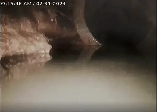
Point of view from the CCTV crawler inside the storm drain.
Discovering an Illegal Sewer-Storm Drain Tie-In
As the push camera advanced through the PVC line in the office, it revealed a critical issue: the sanitary sewer line was discharging into a concrete storm drain – a serious code violation. To confirm the finding, Bacon deployed a CCTV crawler camera into the storm drain to visually locate the push camera from the sewer line.
“I was able to go into the storm line with the crawler camera, and yep, there’s the push camera hanging out into the storm line,” Bacon said.
To further validate the connection, a dye test was performed. Green dye introduced into the office cleanout was observed entering the storm drain, confirming the illegal tie-in.

Green dye introduced into the office cleanout seen in the storm drain with the CCVT crawler camera.
From Field Discovery to Digital Records with SiteMap®
GPRS quickly mobilized to deliver a complete, field-verified map of the restaurant’s sewer system. This enabled the restaurant owners to take immediate action to resolve the backups.
GPRS didn’t stop at identifying the sewer-to-storm drain connection. They also marked each cleanout route on-site and delivered a digital map via SiteMap – ensuring the findings were accessible, shareable, and ready to support future planning and compliance.
“It was a really cool example of our services working exactly as they needed to, and the customer was thrilled,” Bacon shared.
Why Interactive Infrastructure Records Matter
Modern infrastructure management demands more than static maps or scattered documents. It requires a centralized, dynamic solution that transforms verified field data into actionable intelligence. SiteMap delivers exactly that – converting GPRS records into a cloud-based platform that empowers smarter, faster decision-making.
With SiteMap®, users gain:
- Precision Visualization:
Explore layered, color-coded maps of above and belowground systems – like sewer lines, water mains, and fiber optics – with clarity and confidence. - Real-Time Collaboration
Keep every stakeholder aligned with live access to verified records. Whether in the field or the office, teams work from a single source of truth. - Mobile-Ready Access
Open SiteMap from any smartphone or tablet – no app required. View, share, and update records on the go, without delays or downloads. - Role-Based Access Control
Protect sensitive infrastructure data by managing who sees what. Grant subcontractors limited access while maintaining full oversight and accountability. - Flexible Export Options
Export maps, annotated drawings, and files in PDF, DWG, or image formats. SiteMap also supports geospatial data integration, making it easy to share across platforms or import into your existing GIS workflows.
By connecting GPRS’ field expertise with SiteMap, infrastructure teams eliminate guesswork, reduce risk, and gain the clarity needed to plan, build, and maintain with confidence.
The Strength Behind Every Record
Every SiteMap record is backed by GPRS’ industry-leading expertise. With over 500,000 projects completed and a 99.8% accuracy rate, GPRS delivers unmatched precision in utility locating, concrete scanning, and reality capture.
With SiteMap, the restaurant now has a centralized, interactive record of its sewer infrastructure – empowering faster repairs, streamlined compliance, and smarter long-term asset management. What began as a reactive emergency is now a proactive foundation for future planning.
See how SiteMap can transform your infrastructure strategy. Click below to schedule your free SiteMap demo today!