SiteMap® (patent pending), powered by GPRS, provided accurate utility locating and mapping services to help a contractor stay on time, on budget, and safe while installing water lines throughout a 150-acre community college.
Arizona Pipeline Co. enlisted the help of GPRS Project Manager James Turrentine to assist with the water line installation at Gavilan College in Gilroy, California. The institution – originally founded in 1919 as San Benito County Junior College with classes held at Hollister High School – became part of a broader community college district in 1963 that included both San Benito and southern Santa Clara Counties. Following the passage of a local bond in 1966, the college moved to its present location on Santa Teresa Boulevard in Gilroy.
Like many older institutions, Gavilan College lacked accurate existing utility records, making it difficult for Arizona Pipeline to confidently plan trenching operations. Their initial request to GPRS was to locate one known water line on campus.
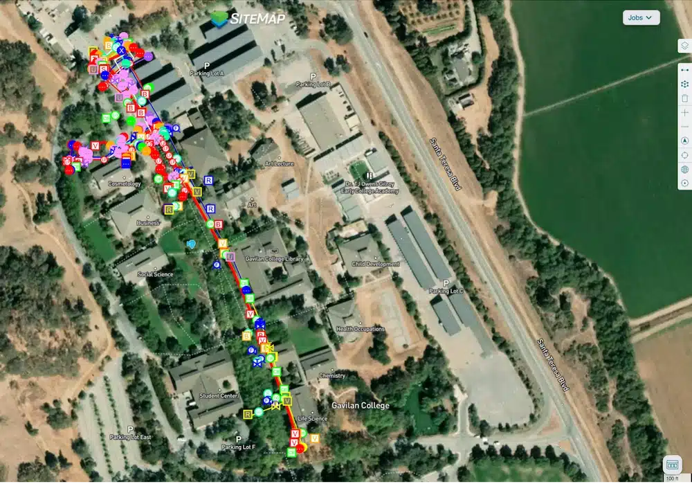
GPRS provided accurate utility locating and mapping services to help a contractor stay on time, on budget, and safe while installing water lines throughout a 150-acre community college.
Using ground penetrating radar (GPR) and electromagnetic (EM) locating, GPRS provided a complete utility mapping solution. GPR works by sending radio waves into the ground, where the reflected signals from subsurface features are captured and displayed as hyperbolas on the system’s readout. These are interpreted by trained Project Managers to determine the depth and position of buried utilities such as pipes or conduits.
EM locating complements GPR by detecting the electromagnetic fields generated by metallic utilities. These signals may come from an active current applied by a transmitter, naturally occurring current in live electrical cables, or passive sources like stray voltage fields and communication signals. The current flow path is completed via grounding — typically using a stake — to close the loop back to the transmitter.
With both technologies in play, Turrentine was able to accurately locate the buried water line, marking its position with flags and paint to guide the excavation effort. He also uploaded the verified data into SiteMap, GPRS’ interactive utility mapping platform.

James Turrentine
SiteMap serves as a secure, centralized digital record that can be accessed anytime from any device. For facility managers and contractors, it provides a reliable foundation for planning, design, excavation, and construction. By replacing outdated or missing as-built documentation with real-world field data, SiteMap significantly reduces risk and helps ensure projects progress with confidence.
How a Water Line Locate Became a Full Site Utility Survey
When Turrentine showed his site contract with Arizona Pipeline the utility locating data he obtained and uploaded into SiteMap, the contact was so impressed that he asked GPRS to locate and map all the buried infrastructure across Gavilan College’s entire campus.
“[Turrentine] showed them in SiteMap their scope of work that they called us out there to do,” said GPRS Area Manager Jake Wright. “And [the client] said ‘Oh wow, we actually have hundreds of [utility] trenches we need to do. Could we do the whole campus like that?’ And Turrentine said ‘Yeah, totally.’”
While every GPRS customer receives complimentary SiteMap Personal access to view the data we collect for them, the platform can be tailored to meet your individual needs. Arizona Pipeline received SiteMap Project access so that their entire team would have access to the accurate, field-verified data collected on-site by Turrentine throughout their project’s lifecycle.
GPRS’ SiteMap Team Members are currently scheduling live, personal demonstrations.
Click below to schedule your free SiteMap demo today!