
Multi-building apartment complexes require a network of buried utilities – which just means there are even more opportunities for subsurface damage to occur when excavating for renovations or expansions.
The owners of a California apartment complex turned to GPRS for their utility locating services and SiteMap® facility management platform to ensure the safe installation of gas lines during an expansion project.
GPRS Project Manager Javier Mendez was called to the property in Orange City, California, to perform a utility locate in preparation for burying several gas lines as part of the complex’s expansion. Initially, the project required Mendez to identify only the gas lines in the area where crews would be trenching to connect gas services to the new addition.
However, based on his training and experience, Mendez anticipated that additional utilities could be present in the area, potentially interfering with the planned excavation if left undetected.
“If you’re going to tie into the existing gas [service], you’ve got to find it first,” he explained. “But they were installing multiple new gas lines, so they needed to know, first, where the existing gas line was, and second, to ensure they didn’t hit anything else while digging.”
Even an empty-looking lot can conceal numerous underground utilities, and striking even one of these lines can lead to significant hazards.
In 2023 alone, there were 189,549 unique reported damages to subsurface utilities, according to data from the Common Ground Alliance (CGA).
The CGA also found that the top six root causes of these damages have remained consistent over the years, accounting for nearly 76% of all incidents. For the second consecutive year, excavation and construction stakeholders were the leading sources of damage reports.
A single utility strike can derail budgets, disrupt schedules, and pose serious risks to workers and bystanders. Multi-building apartment complexes, like the one Mendez worked on, rely on an extensive network of underground utilities, increasing the risk of subsurface damage during excavation for renovations or expansions.
To prevent such consequences, it is essential to comply with regulations by contacting your local 811 service and hiring a professional private utility locating company like GPRS to locate and mark all buried utilities within the excavation site.
GPRS’ SIM-certified Project Managers employ a variety of utility locating tools, including ground penetrating radar (GPR) scanning and electromagnetic (EM) locating, to provide a comprehensive and accurate view of what lies beneath the surface.
GPR scanners work by emitting radio signals into the ground and detecting interactions between these signals and any buried objects such as utility lines or underground storage tanks (USTs). The results appear on a GPR readout as hyperbolas, varying in size, color, and shape based on the type of material detected. Professional utility locating technicians, like GPRS Project Managers, are trained to interpret this data to determine safe excavation zones.
Unlike GPR scanners, EM locators do not directly detect buried objects. Instead, they identify the electromagnetic signals emitted by underground utilities.
These signals can be generated by the locator’s transmitter applying current to a pipe or from current flow in live electrical cables. Conductive pipes can also act as antennas, re-radiating signals from stray electrical fields (detected in Power Mode) and communication transmissions (Radio Mode).
The signals occur when the current from the transmitter travels along conductors (such as a line, cable, or pipe) and returns to the transmitter. This current typically completes the circuit using a ground, which is established via a ground stake.
By utilizing both GPR and EM locating technologies, Mendez successfully identified not only the existing gas main but also several other utilities beneath the job site. He marked his findings on the ground using spray paint and flags, ensuring the excavation team had a clear understanding of where they could and could not dig. Additionally, all data was digitally recorded for future reference using GPRS’ SiteMap® platform.
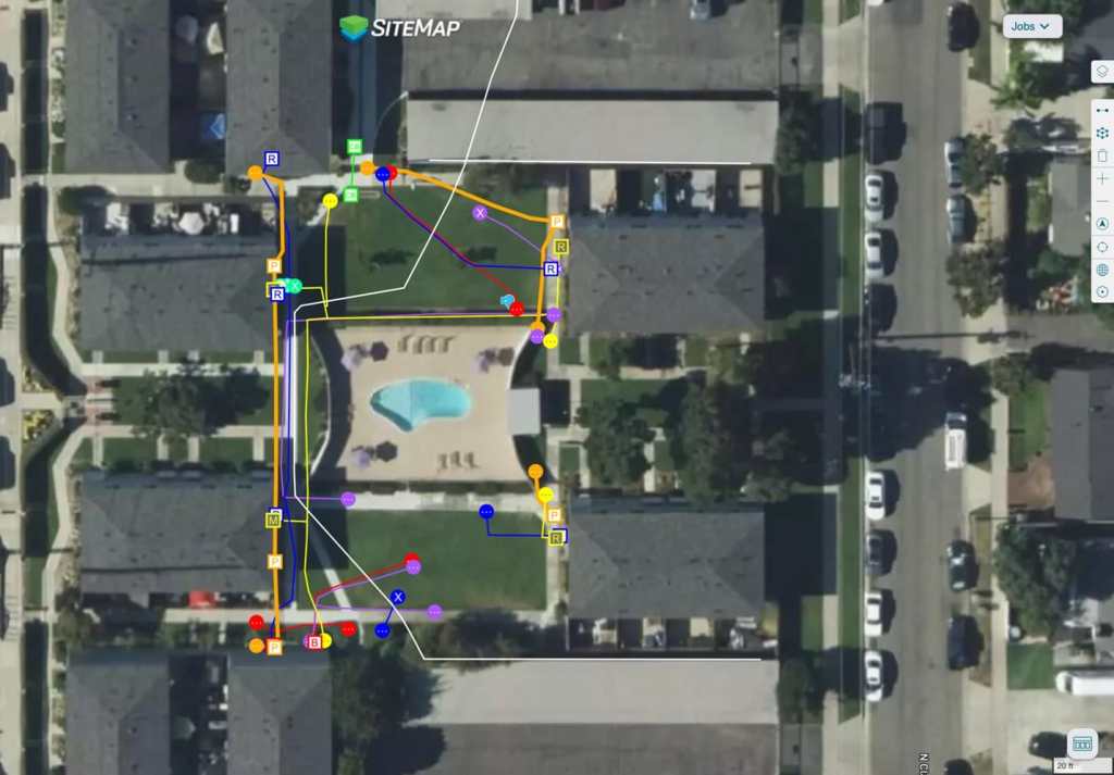
The apartment owners, their contractor and any subcontractors on the expansion project will be able to refer to the data Mendez captured and uploaded into SiteMap® as they move through their expansion project.
SiteMap® is a project and facility management application that provides accurate documentation of existing conditions to safeguard both assets and personnel. It securely stores the field-verified data collected by GPRS’ nationwide team of Project Managers, making it easily accessible for seamless communication and collaboration—whether a project team is working in a single office or multiple facilities across the country.
Available 24/7 on computers, tablets, and smartphones via the SiteMap® Mobile App, this platform ensures crucial information is always within reach.
The apartment owners, their contractor, and any subcontractors involved in the expansion project can refer to the data Mendez captured and uploaded into SiteMap® as they progress through the project. Any modifications or additions to the site’s underground infrastructure can also be documented and updated within the platform, ensuring accuracy and up-to-date records.
“They were just happy to have a platform like that,” Mendez shared. “Showing them the SiteMap® app and how they could click on any utility line to get details on how we found it, its depth, and more… Once they saw it, they were already hooked.”
GPRS SiteMap® team members are currently scheduling live, personal SiteMap® demos. Click below to schedule yours today!