Here at SiteMap®, powered by GPRS, we are more than just a standard facility management software; we are Collaboration Redefined™. Our innovative GIS software platform offers customizable data storage, mapping, and modeling solutions that go above and beyond the usual features available today.
In a recent Safety Chat with Rhett Teller, the Market Segment Leader of Facilities on the east coast for GPRS, he explained how SiteMap® successfully addresses major pain points for facility managers and their project teams.
When asked, “What the major issue is that facility managers face today?” Teller explained that the drawings and as-builts construction teams rely on to communicate their plans are usually disorganized and rarely ever stored in one central location. Most facilities have drawings and utility locate information “all over the place,” or they are completely outdated where, in some cases, “the last drawings we have are on a napkin… from the 1970s.” These haphazard documentation processes can lead to major miscommunication issues across different teams, greatly jeopardizing the project.
With years of experience serving the construction industry, GPRS sees the detrimental effects of such problematic facility management practices first hand. Not only can it be frustrating to communicate when relying on disorganized and/or outdated files, but this issue can also lead to major planning mistakes, work stoppages, and even put the safety of your construction team and the communities surrounding your work site at risk.
This is why we’ve launched SiteMap®, to provide facility managers with the digital planning tools they need to organize all their important maps and models for their projects in one place. As Teller puts it, “SiteMap is the solution,” allowing for all necessary documents and assessments executed by GPRS to be digitized, uploaded, and fully visualized all in one place. Our unique platform breaks up your infrastructure data into different layers, above and below ground. From drone and aerial imaging to subsurface void locating, “all these different layers are going to finally be in one place… It’s mind-blowing!”
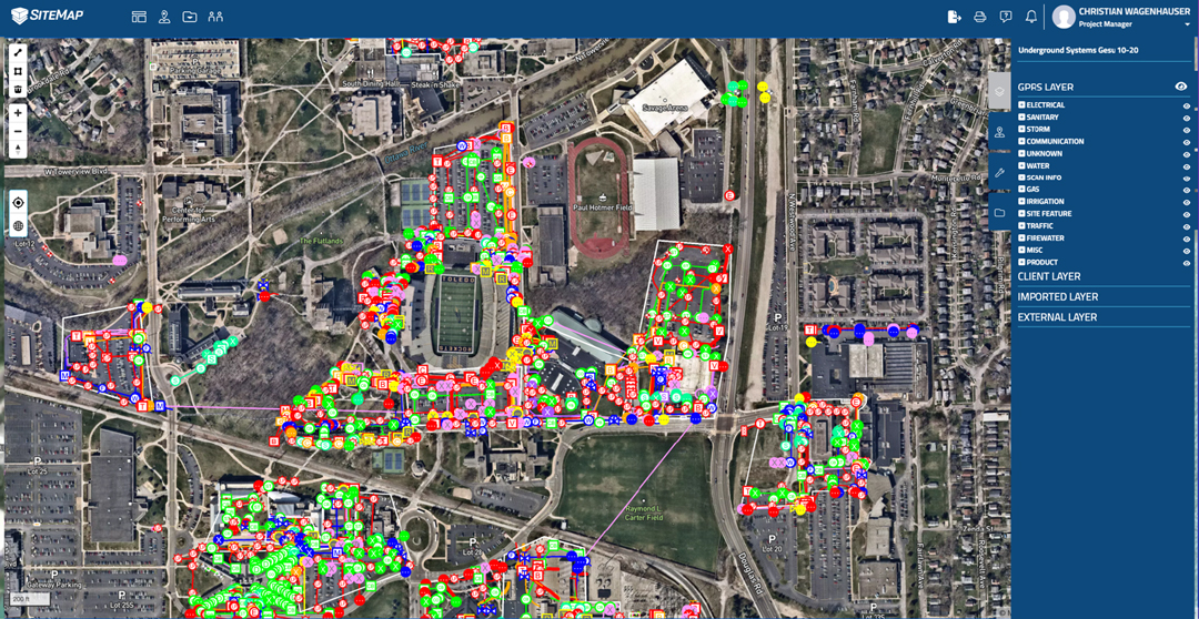
Rather than rely on outdated data storage practices, SiteMap® provides on-demand, secure virtual access so that construction project teams can fully view every square inch of their facilities, top to bottom. This innovative platform comprehensively models every site in the following layers…
- Drone & Aerial Imagery
With higher spatial resolution than traditional satellite generated images, GPRS drone and aerial imagery provides fully rectified orthomosaic photogrammetry. This is a great way to view the most up-to-date topical conditions of your site.
- 3D Digital Spatial Information
This additional layer of data visualization further evaluates every inch of your building’s unique features. This is done through creating 3D tours, dollhouse views, and schematic floor plans so you can view crucial structural information such as reinforcement, utility layouts, and much more. Within SiteMap®, this information can then be geolocated, tagged, layered, annotated, and mapped for instant and clear communication across all departments involved. You can even take accurate “on-center” measurements within your virtual model.
- Concrete Slab Components & Thickness
Concrete slab components and their exact dimensions can be fully visualized by uploading accurate as-built structural drawings and/or 3D models and tours to generate a comprehensive view of all structural and utility components within present concrete slabs. This layer of evaluation is critical for identifying the features that must be fully mapped and recorded before any coring or saw cutting can take place. Maintaining accurate and fully updated accounts of this information is one of the most important steps of the visualization processes. Any mistakes or miscommunications discovered after drilling into concrete structures are often the most costly and potentially hazardous for any construction project.
- Underground Utility & Pipe Inspection Data
Knowing the exact location of all underground utilities present at a given site is another crucial aspect of the project planning phase. Much like concrete scanning data, this information is pivotal. Ensuring accurate measurements and locating take place before any project breaks ground helps to avoid potential line strikes or other costly safety hazards. This is why SiteMap® not only allows you to fully visualize all current as-built positions of your site’s hidden utilities, but it also provides you with the digital tools you need to completely review all sewer and manhole video inspection data. This can even include a fully annotated, NASSCO certified Video Pipe Inspection Report.
- Underground Storage Tank Information (UST)
Accurate and organized documentation of both the horizontal and vertical positioning of your site UST’s are also accounted for in SiteMap®. This can include results from periodic testing or release detection equipment, and inspections of overfill and spill prevention equipment, which can then be easily stored, shared, and reviewed by the whole team.
- Subsurface Void Information
The exact location and size of subsurface voids can be discovered, recorded, and fully mapped through our GPRS capabilities. Once stored within SiteMap®, this data can then be made available for reference and designated viewing. Prior to using any large machinery on your site such as large cranes or trucks, it is important to collect these location records to ensure maximum safety before trenching or other excavation.
Through these services, facility managers are able to streamline infrastructure collaboration. This is achieved through the use of our two key pillars of innovation; our Digital Plan Room and the Map Viewer. With the Map Viewer, the process of viewing facility data has never been easier. This aspect of the platform allows users to connect locational data with specific uploaded documents, models, and specifications. Here, facility managers can track and locationally designate documents so that they are readily available for future reference. The Digital Plan Room serves as a secure, central repository for all necessary facility maps, models, photos, reports, and other as-built documentation. These uploaded files can then be directly linked, cross-referenced, and fully visualized using the Map Viewer. This provides the most efficient way to organize and share all your project’s relevant facility documents, completely paperless and hassle-free.
With SiteMap’s industry-leading digital capabilities, and GPRS’ 99.8% accuracy rate out of 350,000+ projects, construction project teams are able to collaborate better than ever before. This ground-breaking technology streamlines communication, prioritizes safety, and minimizes costly change orders on any project.
Learn how SiteMap®, powered by GPRS, can provide complete facility visualization and a unique tool to help you Visualize the Built WorldTM. Download our brochure, and contact us for a quote today!