How Engineers Can Save Time and Resources With GPR & SiteMap®
Engineers in the construction industry are familiar with time and resource constraints. This happens with many projects. Time is of the essence, and money and materials are finite. Using tools and assets to help you streamline your work and make the most of your resources is essential. One such tool is SiteMap® powered by GPRS.

SiteMap® is a special program that can tell you what’s under the ground where you want to build something. It uses a technology called Ground Penetrating Radar (GPR). This technology can see what’s below the surface that might slow or hinder your project.
Along with 3D mapping software and other lines of service, you will be able to save time and resources in many ways. These various ways include the following.
- Locating Utilities
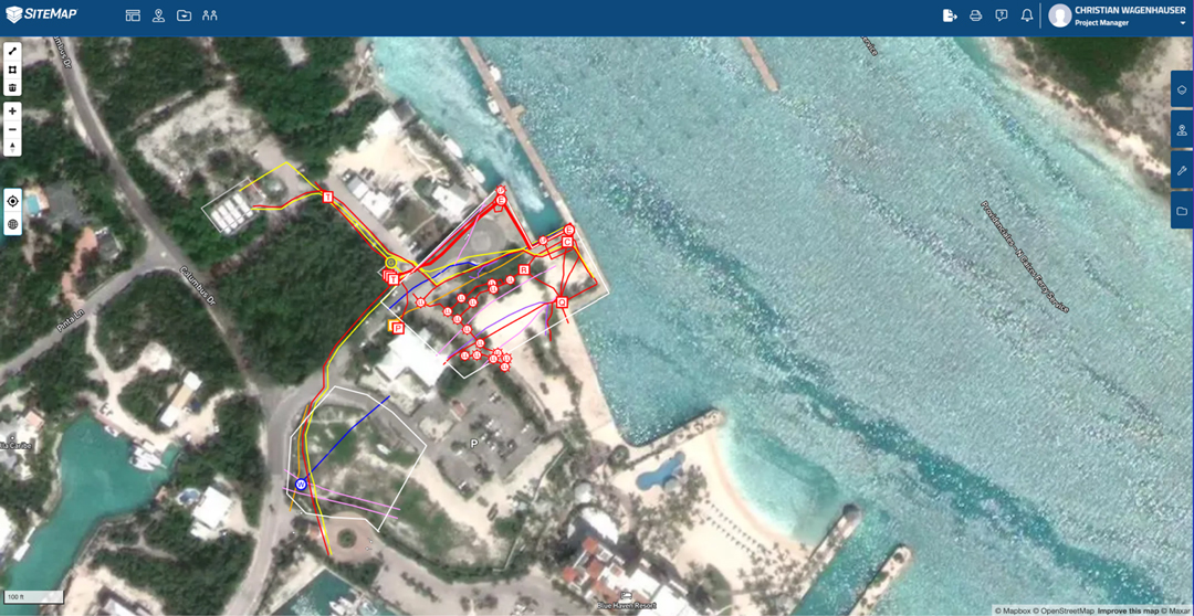
Identifying things like pipes, cables, and electrical lines hidden underground can cause problems. It might cost a lot of money to fix, take longer, and even be dangerous. SiteMap®– uses GPR technology to locate and map the position of underground utilities. This information helps you plan your project better by avoiding potential conflicts.
- Mapping the Site
With the services SiteMap® provides, GPRS can map the entire site. It even creates a 3D model that can help you visualize the project and identify any potential issues. This is helpful when working on projects that involve many structures or levels. It makes prefabrication or site renovations simple and easy too. The 3D model also helps you communicate your vision to stakeholders. This makes it easier to get buy-in and approvals.
- Enhancing Safety
Safety is paramount in any construction project. By identifying potential hazards before you build, you mitigate risks and keep workers safe.
You can use SiteMap® to see underground things like holes, gaps, and other unusual aspects. Also, GPRS experts can help you find these things too. With this information, you can make a safety plan that takes these hazards into account. This keeps people safe and prevents accidents or injuries.
- Saving Time and Money
SiteMap® saves you time and money in several ways. Locating utilities before construction begins saves you costly utility strikes, repairs, and delays. It also helps avoid danger caused by accidental damage to these utilities.
Mapping the site and identifying potential issues allows for better decisions. This reduces your risk of costly change orders and delays.
Also, you will enhance safety and reduce the risk of accidents and injuries. You can avoid costly legal battles and workers’ compensation claims as a result.
What can SiteMap® help me visualize?
SiteMap® customizes to meet the specific needs of your project. Some of the aspects that may be applicable to your next project include…
- Utility Locating
Utility locating services help you identify the location of underground utilities. This includes water, gas, sewer, and electrical lines. This service is beneficial when working on excavation or trenching projects.
- Concrete Scanning
Within concrete structures, this service identifies rebar, post-tension cables, and other subsurface elements. This information will help you to plan demolition, renovation, and repair projects.
- Void Detection
Void detection identifies voids or sinkholes beneath the surface of your construction site. You can use this to develop a comprehensive safety plan considering these hazards.
- 3D Laser Scanning
3D laser scanning technology captures precise three-dimensional data of structures. It does so without causing any harm, enabling accurate measurements, modeling, and analysis. It empowers each project with strong visual information.
How to Use SiteMap®, Powered by GPRS
It’s easy to get started with SiteMap®. First, you’ll need to get in contact with a Business Development Manager or click on the sitemap page. Once you submit your form you’ll wait for approval for your free Personal SiteMap account. Once approved, you can use GPRS’ services in one secure and shareable platform.
Using SiteMap® GPRS’ proprietary software we collect, analyze, and process the data. Dependent on the client’s needs and budget, we use the data to create maps, CAD drawings, point clouds, 3D models, and more.
To get the most out of the experience, it’s essential to work with your Project Manager. Provide them with as much information as possible about the project and your needs. This helps to ensure scans and tests are quick and concise.
As you can see, there are many benefits to using SiteMap®. There are many uses for your construction or facility renovation projects. By identifying hazards you increase safety and reduce the risk of accidents on the job site. You will save costly change orders and budget overruns by working with your Project Manager. This will avoid repairs, delays, and potential legal battles. Identifying these issues before construction begins avoids costly change orders that further delays.
Additionally, you will boost your project planning. Mapping the construction site before construction begins allows for more informed decisions. This helps you complete the project on time and within your budget.
You’ll have easier project communication. If needed, collaborate with stakeholders using accurate as-builts all the way to a 3D model of your construction site. This ensures everyone is on the same page. You will work towards the same goals with more clarity and certainty.
SiteMap® is a revolutionary and powerful tool. It helps engineers save time and money on construction projects. Your projects will never be the same using our technology, 3D mapping, and modeling software. Additionally, we have the unique GIS and data asset platform.
Ensure your next project finishes on time and within budget. Use SiteMap® and GPRS to meet and exceed your needs. Contact us today to learn more about our services. We will help you streamline your work and make the most of your resources.
