The Common Ground Alliance (CGA) highlighted several subsurface damage prevention pilot programs and success stories in its 2023 DIRT Report.
The Common Ground Alliance (CGA) spotlighted multiple subsurface damage prevention pilot programs and success stories in its 2023 DIRT Report.
The report acknowledged efforts in Georgia, New Mexico, Minnesota, and other regions to tackle key challenges in advancing CGA’s mission to reduce subsurface damage to critical underground utilities by 50% by 2028.
“These and other case studies found on the following pages are not just interesting anecdotes – they are blueprints for industry-wide transformation,” wrote CGA President & CEO, Sarah K. Magruder Lyle, in her letter included in the report. “They show us that innovative leaders who embrace innovation, vision and change are making progress right now across the country.”
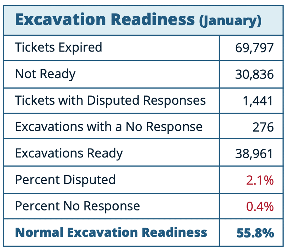
Georgia 811’s Excavation Readiness Metric
In the DIRT Report, the CGA states that unpredictability in 811 ticket response time continues to contribute to excavators’ failure of confidence in the 811 system and needs to be addressed in order to make progress on reducing the top damage root cause year after year: failure to notify 811.
Across 12 states, reported data on the percentage of tickets where all locates were delivered on time ranged from 30-70%, with most hovering around 50%.
Analyzing this issue is challenging due to inconsistent methods for tracking the timely delivery of locates across states and 811 center software systems.
Georgia 811 has developed an “excavation readiness” metric that could help establish an industry standard for evaluating locating across 811 centers.
By using expired tickets as a monthly denominator, Georgia 811 analyzes its positive response system to categorize tickets based on their status. This includes those with disputed responses, no responses, and incomplete responses (“Not Ready”), as well as those with complete and “Excavation Ready” responses. These figures are then used to generate an excavation readiness score.
“Through adoption of similarly-structured positive response system queries or other data infrastructure manipulation, 811 centers across the U.S. must evolve toward a consistent methodology for tracking locating timeliness,” the CGA wrote. “CGA’s One Call Systems International (OCSI) Committee and Damage Prevention Institute (DPI) are both examining mechanisms for establishing, generating and collecting this data on a regular basis to improve the industry’s ability to correct this troubling trend.”
New Mexico and Massachusetts Get Creative With Locating Enforcement
New Mexico and Massachusetts have adopted distinctly different yet equally innovative strategies to enforce proper utility locating practices.
In New Mexico, regulations mandate that excavators submit “warning locate requests” through New Mexico 811 (NM811) when underground facilities remain unmarked and positive responses are not provided. The CGA’s DIRT Report highlights this process as one that “creates accountability and establishes a clear procedure for addressing delays in the locating process.”
Under these rules, facility operators are required to respond to warning locate requests promptly, ideally within two hours. NM811 is responsible for maintaining positive response records and sharing them with the state’s Public Regulatory Commission’s Pipeline Safety Bureau (PSB) for investigation of potential violations. To ensure compliance, the New Mexico PSB began issuing fines to facility operators in 2020, with penalties starting at $811 and assessed monthly.
The Massachusetts Department of Public Utilities’ (MA DPU) Pipeline Safety Division, Damage Prevention Program is responsible for the enforcement of the state’s dig laws.
While reviewing utility damage data, the Division identified two non-gas operators that were not completing locate mark outs within the required timeframes. A deeper analysis uncovered significant weaknesses in the locating and marking process, particularly in communication between the operators and third-party locators.
Rather than immediately imposing substantial financial penalties, the Division collaborated with the non-gas operators to develop an improvement plan. This plan included increasing daily locate audits, expanding training programs, adding staffing resources, and enhancing reporting frequency with other parties. As a result, the on-time locate rate for both operators has risen to nearly 100%.
“This example of collaborative problem-solving by regulators with facility operators to improve locating timeliness is a model that could be employed across the country to enforce locating timeliness,” the CGA wrote.
Minnesota Leverages High Locating Demand to Improve Facility Maps
To meet the high demand for utility locating and improve facility maps for greater efficiency, Gopher State One Call (GSOC), Minnesota’s 811 center, launched a groundbreaking pilot program that provides GPS-enabled utility locating devices to municipalities and other key stakeholders. This initiative offers free trials of these devices, delivering real-time kinematic (RTK) Global Navigation Satellite System (GNSS) accuracy to essential damage prevention groups, including municipalities, engineering firms, contractors, universities, and facility owners.
Through this pilot, field teams can seamlessly integrate precise facility location data into utility mapping software, helping to overcome the challenges and expenses of updating outdated maps.
By granting free access to GPS-enabled locators, the program allows participants to experience the technology’s benefits firsthand and justify its long-term adoption. Reports from users highlight substantial advantages, such as a 50% reduction in field time for engineers and improved accuracy in public works mapping during locate operations.
“The success of this program highlights the potential for leveraging GPS data collected during the locating process to create and update facility maps in real-time,” the CGA wrote. “This approach can lead to improved locating efficiency, reduced damages and better asset management across the industry.”
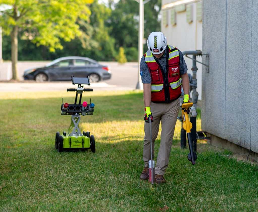
GPRS offers 99.8% accurate utility locating services that utilize ground penetrating radar (GPR) and electromagnetic (EM) locators to fully visualize the built world beneath your feet.
How GPRS Supports CGA’s Mission
GPRS supports CGA’s mission of subsurface damage reduction through our comprehensive suite of subsurface damage prevention and utility mapping services.
We offer 99.8% accurate utility locating services that utilize ground penetrating radar (GPR) and electromagnetic (EM) locators to fully visualize the built world beneath your feet. And when it’s time to share and collaborate with this accurate, field-verified data, SiteMap® (patent pending), GPRS’ project & facility management application, is there to help you plan, design, manage, dig, and ultimately build better.
Click below to schedule your live, personal SiteMap® demo today!
Frequently Asked Questions
How does GPRS communicate the results of their utility locates?
Our Project Managers flag and paint our findings directly on the surface. This method of communication is the most accurate form of marking when excavation is expected to commence within a few days of service.
GPRS also uses a global positioning system (GPS) to collect data points of findings. We use this data to generate a plan, KMZ file, satellite overlay, or CAD file to permanently preserve results for future use. GPRS does not provide land surveying services. If you need land surveying services, please contact a professional land surveyor.
Please contact us to discuss the pricing and marking options your project may require.
Can GPRS locate PVC piping and other non-conductive utilities?
GPR scanning is exceptionally effective at locating all types of subsurface materials. There are times when PVC pipes do not provide an adequate signal to ground penetrating radar equipment and can’t be properly located by traditional methods. However, GPRS Project Managers are expertly trained at multiple methods of utility locating.
Can ground penetrating radar be used to verify known measurements?
We can use GPR to cross-check the measured depth and location of a located utility with existing as-built plans in order to verify the accuracy of plans.
What are the Benefits of Underground Utility Mapping?
Having an updated and accurate map of your subsurface infrastructure reduces accidents, budget overruns, change orders, and project downtime caused by dangerous and costly subsurface damage.
How does SiteMap® assist with Utility Mapping?
SiteMap®, powered by GPRS, is the industry-leading infrastructure management program. It is a single source of truth, housing the 99.8%+ accurate utility locating, concrete scanning, video pipe inspection, leak detection, and 3D laser scanning data our Project Managers collect on your job site. And the best part is you get a complimentary SiteMap® Personal Subscription when GPRS performs a utility locate for you.
Does SiteMap® Work with my Existing GIS Platform?
SiteMap® allows for exporting of data to SHP, GeoJSON, GeoPackage, and DXF directly from any user’s account that either owns or has a job shared to their account. All these file formats can be imported and utilized by other GIS packages if manually imported by the user.