GPRS performs CCTV drainage surveys to detect potential issues that may compromise your drainage system’s functionality.
As part of our comprehensive sewer and stormwater inspection services, CCTV drainage surveys offer the quickest and most effective method for thoroughly evaluating the condition of drains and sewers, including main sewer lines and lateral pipelines.
Our NASSCO-certified Project Managers at GPRS precisely locate blockages and other defects, delivering comprehensive WinCan reports that categorize issues by severity. These reports include both video and photographic documentation, providing you with a clear understanding of the problem so you can make informed repair decisions.

GPRS conducts CCTV drainage surveys to identify issues that could affect your drain system’s ability to properly function.
How Drainage Surveys Work
GPRS Project Managers use state-of-the-art, remote-controlled crawlers and push-fed sewer scopes that are equipped with HD digital cameras and sondes: instrument probes that are detectable from the surface using electromagnetic (EM) locators and allow for mapping of buried sewer systems while they are being inspected for defects.
The Project Manager will run their crawler or scope through the drain system, inspecting it for defects such as clogs, inflow/infiltration, and cross bores. These issues will be geolocated, so you know exactly where you need to dig and can avoid costly and destructive exploratory potholing.
When You Should Have a Drainage Survey Conducted?
If you own or oversee an apartment complex, condominium, commercial property, or any other type of facility, incorporating drainage surveys into your annual preventative maintenance plan is essential to avoid blockages and backups.
Municipalities should also prioritize annual drainage surveys, while homeowners can benefit from inspections to detect potential drainage issues before they escalate.
These surveys are invaluable in determining the root cause of recurring or prolonged roadway flooding and ensuring that new drainage systems, including main sewer lines and lateral pipelines, are properly designed and installed.
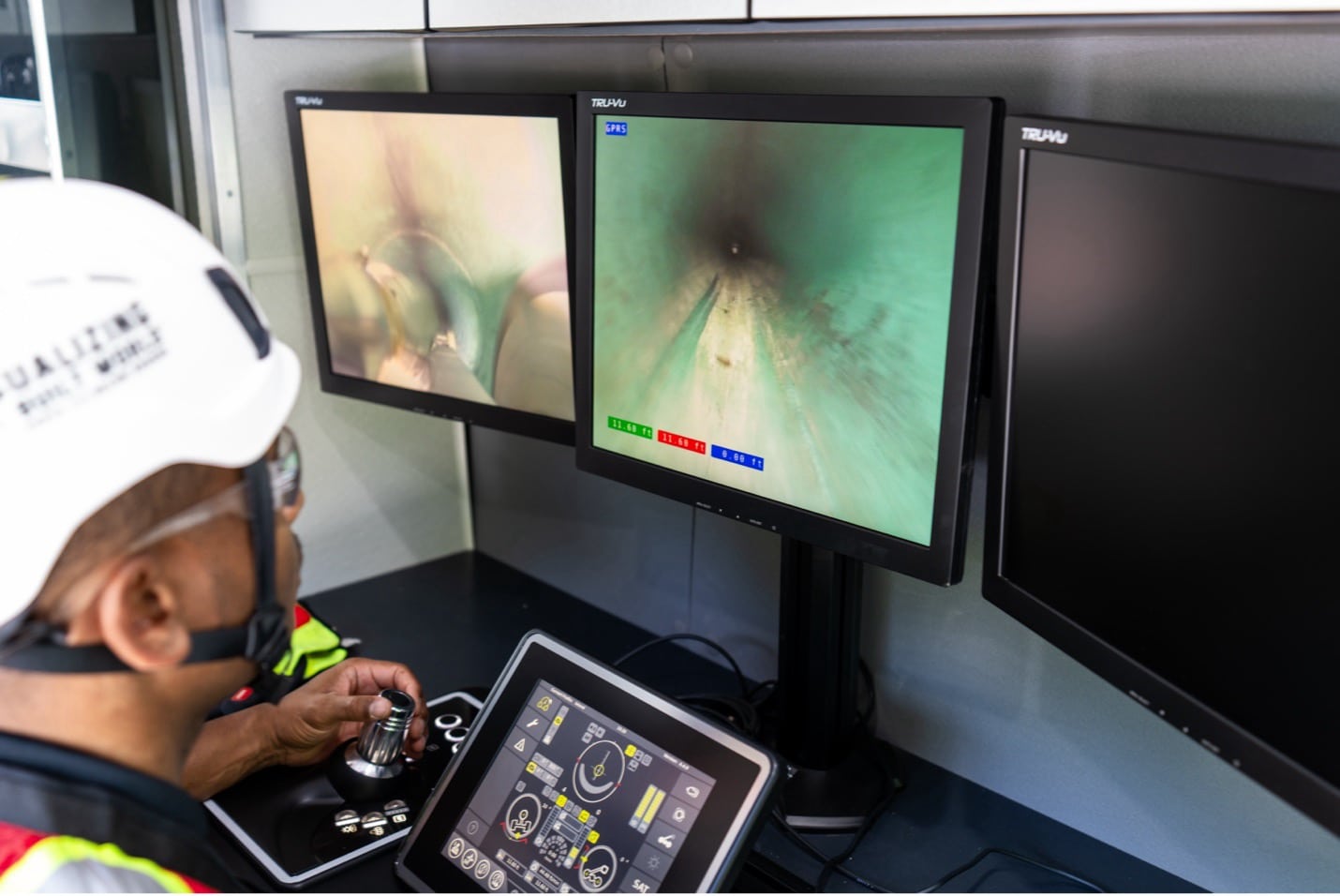
GPRS Project Managers use state-of-the-art, remote-controlled crawlers and push-fed sewer scopes to inspect for defects such as clogs, inflow/infiltration, and cross bores.
The Dangers of Renting or Buying Drainage Survey Equipment
A standard CCTV drainage survey system can cost upwards of $1,000 a day to rent, and $70,000 to purchase. Then you need to know how to operate that equipment; one-day video pipe inspection training courses cost around $400 per person, and a single, two-day certification course through the National Association of Sewer Service Companies (NASSCO) costs upwards of $925 depending on what type of training you require for your project.
Instead, you can hire a professional drainage survey company like GPRS to assess your system quickly and accurately – and at a fraction of what you’ll spend to rent or buy the equipment yourself. Please contact us to learn more about pricing.
SiteMap® Elevates Drainage Surveys
Even accurate infrastructure data can’t help you get the job done right if you aren’t able to access that information when and where you need it.
That’s why GPRS introduced SiteMap® (patent pending), our project & facility management application that provides accurate existing conditions documentation to protect your assets and people.
SiteMap® takes all the accurate, field-verified data collected on your site by our Project Managers and puts it in one single source of truth, securely accessible 24/7 from any computer, tablet, or smartphone.
That means not only our CCTV drainage surveys, but also 99.8% accurate utility locating and concrete imaging, pinpoint-accurate leak detection, 2-4mm accurate 3D laser scanning, and in-house mapping & modeling services are always at you and your team’s fingertips. You’ll eliminate the miscommunications that lead to costly and potentially dangerous mistakes, and plan, design, dig, manage, and ultimately build better.
Click below to schedule your live, personal SiteMap® demo today!