A Case Study for Municipal Utility Management Professionals
A significant utility hardening project is happening in a Florida suburb; a local power utility is moving overhead electric lines underground. This undergrounding of utility lines often requires the use of horizontal directional drilling (HDD), which is the case here. This method, though less invasive than traditional open-cut excavation, carries the risk of cross bores—accidental intersections with existing underground utilities – which can lead to severe consequences, including soil contamination or worse, accidents involving gas or electric lines.
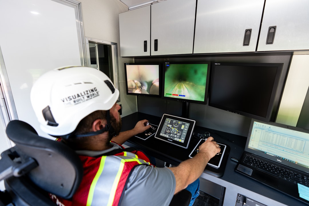
GPRS is assisting in the project by providing comprehensive subsurface utility locating and sewer pipe inspection services. Before drilling began, GPRS Project Manager Nate Simmons, used advanced video pipe inspection technology to map and inspect all sewer lines in the project area. This thorough approach ensures that all sewers, mains, and laterals are accurately marked, helping to prevent dangerous cross bores during the installation process.

GPRS Project Manager and Video Pipe Inspection specialist, Nate Simmons
“We’re marking out all sewers, sewer mains, and sewer laterals all the way up to each house, or as far as we’re able to go with our equipment,” Simmons explained. “Then we’re marking our findings with spray paint and flags.” Those findings are then geolocated utilizing either GPS or RTK satellite technology and directly uploaded to SiteMap® (patent pending) for nearly instant delivery of the utility locations to the customer.
Simmons and the entire nationwide GPRS team utilize state-of-the-art, remote-controlled sewer pipe inspection rovers equipped with sondes. These sondes, detectable from the surface with electromagnetic (EM) locators, allow the team to map sewer systems while simultaneously assessing their condition. This process ensures that any potential issues, such as clogs or structural defects, are identified before HDD begins, significantly reducing the risk of accidents.
In addition to mapping sewer lines, GPRS Project Managers employ a combination of EM locating and ground penetrating radar (GPR) to locate other buried utilities. EM locators detect electromagnetic signals from metallic pipes and cables, allowing the team to accurately trace the paths of underground utilities. Meanwhile, GPR scanners emit radio signals into the ground, detecting interactions with buried objects like utilities, underground storage tanks, and structural supports. This dual approach ensures a comprehensive understanding of the subsurface environment, further mitigating risks during the undergrounding process.
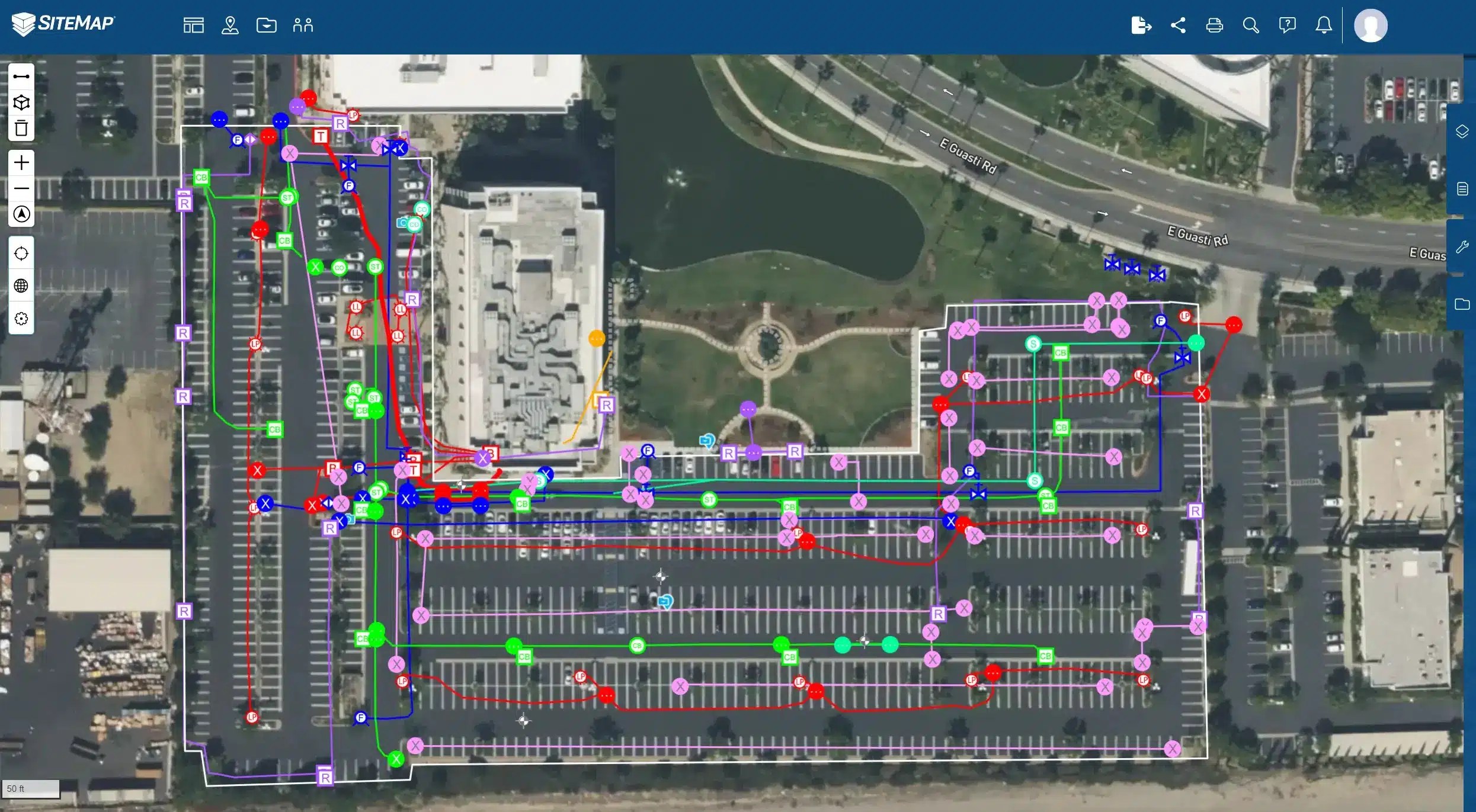
One of the most significant advantages of GPRS’ services is the integration of all collected data into their proprietary SiteMap® platform. SiteMap® is a data delivery and management tool that centralizes utility data, making it easily accessible to project managers and other stakeholders. This platform plays a critical role in the success of the project, enabling real-time updates and seamless communication among teams. With all underground utility data stored digitally, municipal utility managers and those involved in hardening the electrical lines can quickly access the information they need to make informed decisions, adjust plans on the fly, and ensure that the drilling process proceeds safely and efficiently.
The importance of having accurate, up-to-date underground utility data cannot be overstated. In projects like this one, where the safety of workers and the public is at stake, having reliable information about the location and condition of existing utilities is essential. SiteMap® provides a level of transparency and accessibility that traditional paper records or disjointed data systems simply cannot match. By ensuring that all relevant and accurate data is stored in a single, easy-to-access location, SiteMap® enhances collaboration, reduces the likelihood of errors, and ultimately contributes to the overall success of the project.
As the project progresses, GPRS has continued to demonstrate its commitment to safety and efficiency. The boots-on-the-ground Project Managers remain flexible, adjusting their plans to accommodate the client’s needs and responding quickly to any changes in the project’s scope. This adaptability, combined with the use of advanced technology and the SiteMap® platform, allows GPRS to maintain a high standard of service while minimizing the risk of delays or accidents.
This particular utility hardening project highlights the importance of accurate existing conditions documentation and availability of underground utility data in digital formats. By utilizing cutting-edge technology and ensuring that all data is stored and accessible via a centralized platform, GPRS customers are able to access and utilize a comprehensive picture of their community’s subsurface environment, helping to prevent cross bores and other potential hazards. This approach not only enhances the safety and efficiency of the project but also sets a new standard for how utility installation projects should be managed in the future.
To learn more about how SiteMap® could give you the municipal utility infrastructure management information you need, click here.