Boise State University Leverages SiteMap® to Accurately Map Electrical Infrastructure
Boise State University, the largest higher education institution in Idaho, recently partnered with GPRS to gain a detailed and accurate understanding of its buried electrical infrastructure. By utilizing GPRS’ innovative infrastructure mapping platform, SiteMap® (patent pending), the university can now more effectively manage and maintain its electrical systems without the risk of unexpected disruptions or safety hazards.
GPRS Project Manager Elias Iske played a key role in this project, working closely with engineers from both Boise State University and Cator Ruma & Associates to locate and map the depths of the primary electrical lines that serve the university’s 192-acre campus.
“Boise State operates on a separate power grid from Idaho Power, the local utility company,” said Iske. “Our goal was to work alongside the university’s electrical engineers and the team at Cator Ruma to precisely identify and document the location and depth of these critical electrical lines.”
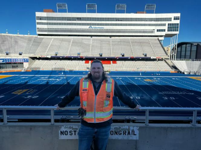
GPRS Project Manager, Elias Iske located & mapped the primary electric lines that power Boise State’s 192-acre campus.
Understanding Boise State’s Electrical Infrastructure Needs
Founded in 1932 as a junior college, Boise State became a four-year institution in 1965 and achieved university status in 1974. Today, it boasts the highest enrollment of any university in Idaho and is renowned for its vibrant campus life, school spirit, and academic programs. Boise State’s campus is a hub of student activity, and maintaining that dynamic environment requires careful management of its infrastructure to avoid unnecessary disruptions.
Niche, a college ranking and review site, recently ranked Boise State as the top college in Idaho for student life, and 89th among more than 1,300 campuses nationwide. However, maintaining this energetic atmosphere can be challenging if parts of the campus are regularly shut down due to utility strikes or repairs.
Accidentally striking underground utilities while performing excavation or maintenance work can have serious consequences, from disrupting daily campus activities to creating dangerous situations and delaying projects. Boise State sought to proactively avoid such risks by obtaining precise documentation of its underground electrical infrastructure before beginning any new construction or maintenance projects.
How GPRS Ensured Accurate Utility Locates
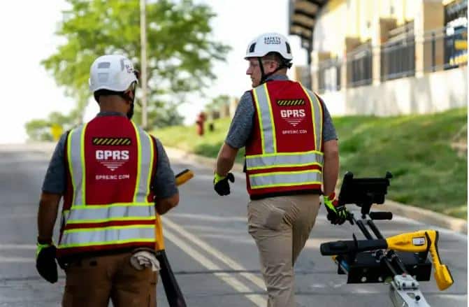
GPRS Project Managers are SIM-certified to utilize complementary technologies to accurately capture subsurface utilities with 99.8% accuracy
To meet Boise State’s needs, GPRS utilized two key technologies: electromagnetic (EM) locating and ground penetrating radar (GPR). Together, these tools allowed the team to locate and map the university’s electrical lines with precision and without the need to access dangerous components like transformers and switches.
CAPTION: GPRS Project Managers are SIM-certified to utilize complementary technologies to accurately capture subsurface utilities with 99.8% accuracy
EM locating works by detecting electromagnetic signals emitted by metallic pipes and cables. These signals can come from the flow of electricity through live cables or from a conductive pipe that re-radiates signals from stray electrical fields or communication transmissions. In some cases, the EM locating device can also create a signal by applying a current to the pipe, making it easier to detect.
GPR technology complements EM locating by emitting radio signals into the ground or through concrete slabs. When these signals encounter buried objects such as utilities, underground storage tanks, or structural supports like rebar, the scanner detects the interaction and maps the object’s location. This dual approach helps ensure that all underground utilities are identified accurately.
For this project, Iske and his team used both EM locating and GPR scanning to map the university’s electrical lines. Although GPRS typically marks the locations of buried utilities with spray paint, Boise State requested that only small red dots be used to minimize the visual impact on the campus’s grass, sidewalks, and roads. GPRS accommodated this request while maintaining a high level of accuracy in its markings.
SiteMap®: A Long-Term Solution for Infrastructure Management
Marking the physical location of underground utilities is an important step, but it’s not a permanent solution. Over time, spray paint, chalk, and flags fade or disappear, making it easy for future project teams to lose track of the exact locations of these critical systems. To address this challenge, GPRS developed SiteMap®, a GIS-based platform designed to store and manage detailed, field-verified data about a site’s subsurface infrastructure.
SiteMap® serves as a single source of truth for infrastructure data, accessible 24/7 from any computer, tablet, or smartphone. By storing and organizing this information in a central platform, SiteMap® ensures that project teams, engineers, and facility managers can easily access historical data and avoid costly mistakes during future maintenance, renovations, or construction projects.
The accurate map of Boise State’s buried electrical infrastructure created by Iske and his team was uploaded into SiteMap®, allowing the university’s engineers and their partners at Cator Ruma to plan, design, and manage future projects with confidence. The platform provides over 1,000 data points, including the precise locations and depths of dozens of electrical lines across the campus.
Delivering More Than Expected
Boise State University was particularly pleased with the speed and precision of the work. Iske noted that one of the advantages of GPRS’s approach was that it didn’t require opening transformers and switches to locate the electrical lines, which would have posed safety risks and could have disrupted campus operations. Instead, the use of EM locating and GPR scanning allowed the team to gather detailed data without impacting the campus.
“In the end, the data provided through SiteMap exceeded Boise State’s expectations,” said Iske. “The platform offered over 1,000 points of information for review, and the depth and detail of the electrical line mapping was even more extensive than they had anticipated. They were very happy with how quickly we were able to complete the project.”
Cator Ruma also praised the results, stating, “The information was extensive, detailed, and highly useful for the client.”
Looking Ahead: How GPRS Supports Long-Term Infrastructure Planning
By leveraging cutting-edge technology like SiteMap® and GPR scanning, GPRS was able to help Boise State University take a proactive approach to managing its electrical infrastructure. The accurate and detailed mapping provided by GPRS not only helps the university avoid disruptions and costly mistakes but also supports better long-term planning and maintenance.
With this data now available in SiteMap®, Boise State is well-equipped to handle future construction, operations, and maintenance projects without the risk of damaging critical underground systems. As universities and other large institutions continue to grow, accurate infrastructure mapping will become increasingly essential for ensuring smooth operations and campus safety.
In partnering with GPRS, Boise State has taken an important step toward safeguarding its infrastructure and maintaining its status as a leading educational institution in Idaho. Through innovative tools like SiteMap® and advanced scanning techniques, GPRS is helping organizations like Boise State build, manage, and protect their campuses for years to come.
If you would like a complimentary demonstration of SiteMap’s capabilities for your facility or organization, click below.