Interactive Software That Does More Than Deliver: It Connects, Organizes, and Future-Proofs Your Infrastructure Data
Standing on a construction site, ready to dig. Are you confident relying on the decade-old paper map in your hand? Knowing the entire success of your project – your budget, your team’s safety, your timeline – hinges on the accuracy of that outdated record?
This is exactly why SiteMap® (patent pending) was created.

SiteMap® gives you accurate records in a customizable, budget-friendly software platform with an interactive interface that updates in minutes.
SiteMap is much more than just a software or deliverables platform. It’s a real-time, collaborative, data-rich cloud-based solution that transforms above and below-ground uncertainty into confidence. It’s where as-built records meet interactive visualization, where project collaboration becomes intuitive, and where data works for you.
Why the Industry Needs SiteMap®
Contractors, architects, engineers, and facility managers rely on accurate information – but much of that information is fragmented, outdated, or inaccurate. Paper as-builts fade. Digital files get lost. Contractors don’t communicate. Field workers rely on gut instincts while office teams swim through PDFs.
And you know what happens next…
- Costly utility strikes
- Rework and delays
- Safety hazards
- Frustration across teams
According to a white paper published by Engineering News-Record, communication breakdowns are responsible for approximately $1.7 billion in annual losses within the U.S. construction industry. In addition, rework is estimated to account for around 5% of total contract values – adding a significant financial burden to already complex projects.
SiteMap® was developed to meet all these needs.
More Than a Deliverable
SiteMap is a cloud-based, interactive software solution that delivers, organizes, and visualizes utility data for building industry professionals. Every GPRS project – whether it’s concrete scanning, utility locating, 3D laser scanning, or video pipe inspection – is delivered through SiteMap. However, your data and our service doesn’t stop at delivery – they equip you for what comes next.
With SiteMap, you don’t just get records – you get interactive maps, digital twins, searchable layers, and a centralized, secure Digital Plan Room. You get the ability to collaborate in real time, customize access for different stakeholders and vendors, and track infrastructure over time.
Core Features of SiteMap®
Interactive Utility Mapping
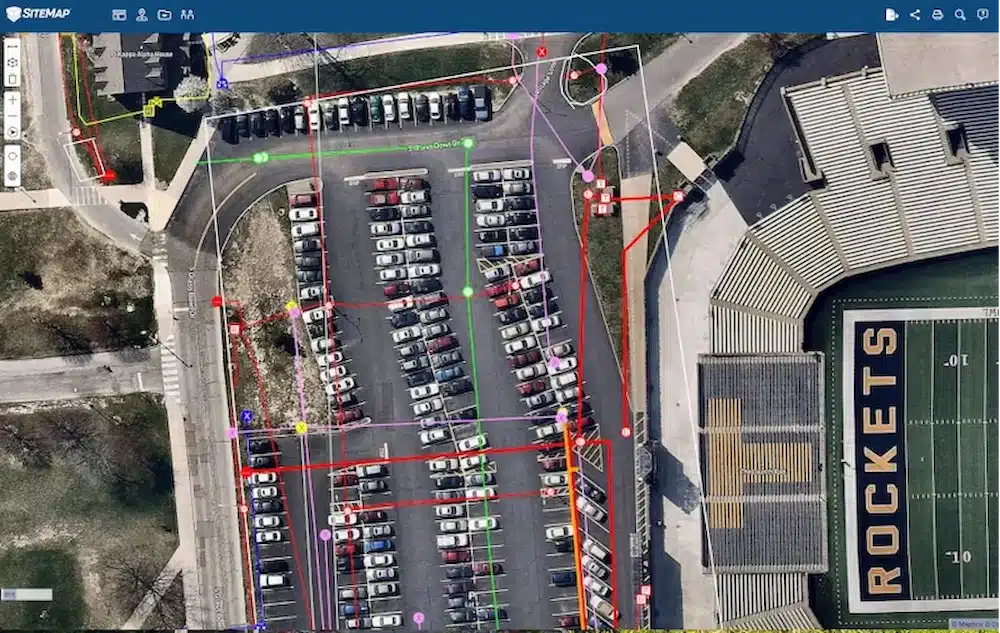
SiteMap turns complex underground systems into interactive digital maps. You can zoom, filter, and explore verified utility data. From gas lines to fiber optic cables, SiteMap gives you complete confidence.
Each utility is layered, color-coded, and searchable. You can isolate water lines, check depths, or overlay new design files with a single click.
This isn’t a static PDF. It’s an interactive, living map, always current and accessible from any device.
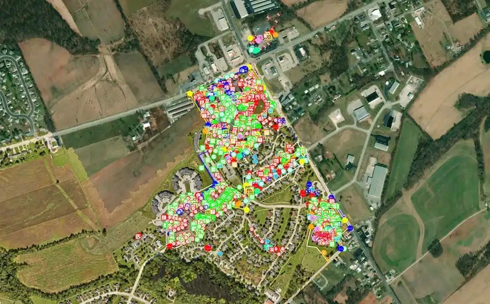
SiteMap® is designed to provide accurate existing conditions documentation to protect assets and people.
Reality Capture & Digital Twins
SiteMap supports 3D laser scanning, photogrammetry, and Virtual WalkThrus. This means you can capture existing conditions with accuracy and explore job sites remotely.
Digital twins are much more than a pretty image – they’re incredibly useful. You can take accurate measurements, validate installation points, and visualize as-builts in their true form. Great for planning, inspection, and even litigation defense.

Our updated reality capture features allow you to access and organize virtual tours and point clouds, all in one place. You can filter by file type, search by job details, and interact with your data for a more streamlined experience.
Centralized Record Storage
SiteMap includes a Digital Plan Room where all GPRS-collected scans, drawings, files, and notes from your project are securely stored in a searchable format. You can:
- Access project deliverables with a few clicks
- Filter by location, date, or utility type
- Share files with internal or external stakeholders, based on role or need
For customers who need a more comprehensive records solution, upgraded access is available. These enhanced tools allow teams to upload and aggregate historical documents, organize custom file sets, and version as-builts and record drawings over time.
No more disconnected folders or scattered PDFs. Just centralized, field-verified documentation – accessible whenever you need it.
Real-Time Collaboration
Field teams can upload scans, photos, and notes directly from the job site. Office teams see it in real time. Subcontractors can be granted limited access to specific maps. SiteMap keeps everyone aligned without endless email chains or delayed file transfers.
Every update is live within minutes, not days. And everyone works off the same source of truth.
With GPRS tools like WalkThru 3D, FLRPLN, and ProCap, SiteMap enhances visibility even further – giving stakeholders the ability to review utility data, site progress, and existing conditions remotely, without ever stepping on-site. This enables faster approvals, fewer site visits, and smarter decision-making across the entire project team.
Tailored Solutions for Any Operation
SiteMap offers three scalable solutions depending on your needs:
Ideal for single construction sites or jobs, SiteMap Project includes access to all GPRS-collected utility data, maps, and deliverables for one active project site. This control-based solution provides everything needed to stay compliant, avoid strikes, and maintain efficient collaboration throughout the project lifecycle.
Designed for facility managers, SiteMap Pro supports one campus or facility with ongoing access to layered records, repair tracking, and aggregated historical documentation. Universities, hospitals, and manufacturers rely on SiteMap Pro to support long-term asset management, reduce downtime, and plan capital improvements with data-backed confidence.
Or step up to the enterprise-level solution for companies managing multiple facilities, campuses, or portfolios. SiteMap Team provides cross-project collaboration, unlimited user control, and continuous access, making it perfect for facilities directors and managers, construction executives, and utility providers managing complex networks with large teams.
Who Uses SiteMap®?
If you interact with the built world, SiteMap is for you:
- Contractors
- Engineers
- Architects
- Facility Managers
- Utility Providers
- Project Owners
More than 1,800 organizations already use SiteMap. Some of the better known include names like Whiting-Turner, Arcadis, Consigli, and the University of Toledo.
Across all industry sectors, SiteMap reduces friction, mitigates risk, and enhances long-term planning. It provides every user type with a common visual language and access control appropriate to their role.
Real-World Impact: University of Toledo
Before SiteMap entered the picture, the University of Toledo had hundreds of underground utilities with no reliable record of where they were. Excavations were slow, risky, and expensive.
GPRS scanned the campus. SiteMap organized the data. Now, the University’s facilities teams can instantly view every utility across campus. Planning is faster. Maintenance is safer. Budgets are more accurate.
Director Dan Perry describes it most accurately: “The definition, the detail you provide with SiteMap’s data is just so much better than anything we’ve had.”
SiteMap® provides UToledo accurate as-built data in one secure central location to manage the construction and renovation projects on campus, from planning and bidding to physical construction and completion.
Why SiteMap® Works: The Philosophy Behind the Platform
SiteMap was developed by building industry professionals. Every feature is rooted in real-world problems. Every tool is specifically designed for the way construction, facilities, and engineering professional’s work.
At SiteMap the purpose is to make your life easier – and safer. Every feature is engineered to address real-world challenges:
Enhanced Safety
By providing accurate and up-to-date information about underground utilities, SiteMap helps mitigate the risk of utility strikes, accidents, and injuries during excavation or construction activities. Users can identify potential hazards, implement safety measures, and minimize downtime, ensuring a safe working environment for all stakeholders.
Improved Efficiency
SiteMap helps streamline workflow processes, reduces manual tasks, and optimizes resource allocation, leading to increased efficiency and productivity. The ability to access utility maps and data in real-time, both in the office and in the field, facilitates quicker decision-making and faster response to emergencies or changes in project conditions.
Cost Savings
SiteMap can minimize the costs associated with utility damage, clashes, reworks, and project delays by enabling proactive planning, risk assessment, and conflict resolution. By avoiding costly mistakes and optimizing construction activities, users can achieve significant cost savings over the lifecycle of infrastructure projects.
Regulatory Compliance
SiteMap can facilitate compliance with regulatory requirements and industry standards for underground utility management. Users can use their SiteMap® to help them generate reports, documentation, and as-built drawings to demonstrate adherence to safety regulations and permit conditions, minimizing legal liabilities and ensuring project success.
More Benefits You Can Count On
Role-Based Access
Control who sees what. Give subcontractors access to only the data they need. Restrict visibility on sensitive infrastructure. Build in accountability and security.
Mobile-Ready
Access maps and records from any smartphone or tablet. No apps to install. No updates to manage. Just open SiteMap in your browser and go.
Export Options
Export maps, files, and annotated drawings in PDF, DWG, or image formats. Print-ready and presentation-friendly to share data with stakeholders. And if your team uses other GIS platforms? SiteMap supports geospatial data integration, so you can easily import or export compatible files for use in other systems.
Why SiteMap® is More Than a GIS
Geographic Information Systems (GIS) have long been foundational tools for mapping and managing infrastructure. But even the best GIS is only as useful as the data it’s built on. If the inputs are flawed – outdated as-builts, missing locates, siloed datasets – then the outputs become unreliable. Potentially leading to utility strikes, rework, or worse.
This is where SiteMap changes the game.
While traditional GIS tools simply visualize existing data, SiteMap transforms how that data is created and consumed. By tying every map directly to real-world GPRS-verified locates and scans – captured by highly trained Project Managers using the Subsurface Investigation Methodology (SIM) – SiteMap ensures you’re not just seeing infrastructure, you’re seeing the truth.
Accurate visualization isn’t new. Dating back to the 1960s, pioneers like Jacques Bertin helped formalize how data could be graphically represented for deeper insight. Today, GPRS builds on that legacy through Intelligently Visualizing The Built World®, bringing infrastructure to life with interactive and precision-driven maps that are 99.8% accurate.
Rather than being “just a GIS,” SiteMap enhances GIS outputs by supplying clean, accurate, and aggregated subsurface data at the source. It’s a centralized platform that breaks down data silos, enabling all stakeholders – contractors, engineers, facility managers, architects, municipalities – to access a single source of truth.
SiteMap delivers this by:
- Aggregating verified utility data from 500+ nationwide Project Managers
- Supporting advanced visualization and conflict analysis with real, field-verified inputs
- Offering historical context, real-time updates, and exportable formats for integration with other GIS platforms
The result? Visualizations that are easy to understand, accurate to trust, and actionable at every stage. From design and excavation to asset management and long-term planning.
With SiteMap, you’re seeing with clarity and confidence.
From Field to Office: Bridging the Disconnect
Office teams often operate on different systems than field teams. That disconnect can create massive inefficiencies, rework, and safety risks. SiteMap connects these two worlds by making it easy to upload, view, and manage utility maps, files, and project records in real time.
Field teams can upload photos, scans, annotations, and observations from the job site directly into the platform. Office teams can view that same data instantly – no more delays, data silos, or crossed wires.
This real-time data-sharing closes the loop and fosters a collaborative culture of transparency, speed, and shared accountability.
Security and Ownership
Your data is your asset. SiteMap doesn’t gatekeep or restrict your access. You own it. You control who sees what. And you can export, share, or print as needed.
This level of control is rare – and it’s a key part of SiteMap’s promise: It’s your data. You should put it to work for you.
A Platform That Grows With You
Whether you’re just starting your digital transformation or leading the charge at a Fortune 500 firm, SiteMap grows with your business. It’s customizable, scalable, and built to integrate with the tools you already use.
Take control of your records.
Take control of your infrastructure.
Take control of your job site.
Take control with SiteMap.
Infrastructure Intelligence
SiteMap is access to view the full picture:
- What’s underground
- What’s aboveground
- What’s been done
- What’s changing
- Who’s accessing what
- When things need to happen next
It’s all the information you need about your built world, in one digital workspace.
Control the Data, Control the Damage
Everything in construction comes down to control. Control the site. Control the schedule. Control the budget. But none of that matters if you can’t control the data.
SiteMap is your single source of truth for every pipe, conduit, scan, record, and drawing on your job site – past, present, and future.
It connects your team.
It protects your people.
It powers your decisions.
Click below to schedule your live, personal SiteMap demo today!